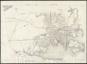
Skip to search
Skip to main content
Skip to first result
Digital Commonwealth
Folders
Sign Up / Log In
Search for
Search
Search
Search
Basic
Advanced
Explore
Map
Collections
Institutions
Formats
For Educators
Primary Source Sets
Lesson Plans
Using Primary Sources
Searching Digital Commonwealth
For Institutions
Join Digital Commonwealth
Conferences, Trainings, & Events
How to Contribute Collections
Digitization Services
Board & Committees
Frequently Asked Questions
About
About Digital Commonwealth
News & Announcements
Copyright & Terms of Use
Harmful Content Statement
Partners
API
Contact Us
Search
Search Constraints
Start Over
Save Search
Your search:
norman leventhal
✖
Remove constraint norman leventhal
« Prev. |
1
-
100
of
11,737
|
Next »
Sort
by relevance
relevance
title
date (asc)
date (desc)
Number of results to display per page
100
per page
per page
10
per page
20
per page
50
per page
100
per page
View results as:
List
list view
Maps
map view
Gallery
grid view
Search Results
1.
Norman B. Leventhal Map Center Collection
2.
Boston distance to the nearest supermarket
3.
Boston open space and supermarkets
4.
Map of Jamaica : prepared from the best authorities by order of His Excellency Sir Henry Wylie Norman, G.C.B. G.C.M.G., C.I.E.,...
5.
Boston Public Library
6.
A type-ology of population in Massachusetts
7.
A shared problem, an unequal burden : causes & consequences of climate change
8.
Tax parcels that would have been underwater in 1630
9.
A hexagonal chart of yearly snowfall in New England up through and including November 1, 2020
10.
United States bee colonies
11.
Barton Street, West End
12.
East Boston flood risk
13.
Fairbanks Street, Brighton
14.
Oxford Street, Chinatown
15.
Health success : Massachusetts well-prepared to deal with health issues from hazardous sites
16.
The great transit desert
17.
Hotbeds of contamination : the toxicity of our cities
18.
Map of public transportation routes in Greater Boston served by the Massachusetts Bay Transportation Authority comprising 64...
19.
Rethinking hazardous beliefs : challenging perceptions of the "dirty city"
20.
Suburban Boston teachers are the highest earners
21.
Suburban Boston teachers are the lowest earners
22.
Change in median housing value, 2010 to 2018
23.
Change in white population (non-Hispanic), 2010 to 2018
24.
Disconnected : Boston's free wi-fi leaves many in the dark
25.
Mean travel time to work
26.
Most popular mode of commuting : 2014-2018 American Community Survey
27.
Percent foreign-born
28.
Plenty of free wi-fi is keeping Boston connected!
29.
Proportion of units where rent costs over 30% of resident's income
30.
Total foreign-born
31.
A city of unequal risks
32.
How we get around today
33.
Boston's top 5 immigrant populations
34.
Health crisis : Massachusetts' low income families more likely to live near hazardous sites
35.
Boston over Time
36.
Western Massachusetts closed to the public
37.
Western Massachusetts open space abounds
38.
Boston kids count
39.
Map of Salem Village 1692
40.
Map of the City of Salem
41.
Map of Salem and Surrounding Places
42.
[Map of Salem, Mass.]
43.
Deputy Mayor Henry Scagnoli with members of the Boston Redevelopment Authority, Center Associates, and Beacon Construction.
44.
Chart of the harbours of Salem, Marblehead, Beverly, and Manchester, from a survey taken in the years 1804, 5 & 6
45.
Chart of the harbours of Salem, Marblehead, Beverly, and Manchester, from a survey taken in the years 1804, 5 & 6
46.
Plan of Salem Common
47.
Mapping Boston Collection
48.
A Plan for the Town and Harbour of Boston
49.
Plan of the Town of Salem
50.
A new map of the United States including part of Louisiana : from the best authorities
51.
Coast of Nova Scotia from Barrington Bay to Cape Blancherolte
52.
A chart of the Banks of Newfoundland, drawn from a great number of hydrographical surveys, chiefly from those of Chabert, Cook...
53.
Chart of the streights of Belle Isle
54.
A chart of South Carolina and Georgia
55.
Chart of the streights of Belle Isle
56.
A chart of South Carolina and Georgia
57.
Chart of the Bay of Fundy from Machias Bay to 64°35' west longitude
58.
Chart of the Streights of Belle Isle
59.
A chart of the Banks of Newfoundland
60.
A new general chart of the West Indies from the latest marine journals and srveys regulated and ascertained by astronomical...
61.
A new general chart of the West Indies from the latest marine journals and surveys regulated and ascertained by astronomical...
62.
A chart of the coast of New England from the South Shoal to Cape Sable including Georges Bay from Holland & actual surveys
63.
A chart of South Carolina and Georgia
64.
A chart of the Coast of America from Wood Island to Good Harbour from Hollands surveys
65.
A chart of the coast of America from Wood Island to Good Harbour from Hollands surveys
66.
Chart of the coast of America from Cape Hateras to Cape Roman
67.
Chart of the coast of America from Cape Hateras to Cape Roman
68.
Chart of the coast of America from Cape Hateras to Cape Roman
69.
A new chart of the sea coast from the island of Cyenne to the river Poumaron comprehending Surinam Berbice Demerary & Essequebo...
70.
A chart of the banks and part of the coast of Newfoundland including the islands of Sable and Cape Breton
71.
A new and accurate chart of the Bay of Chesapeak including Delaware Bay with all the shoals, channels, islands, entrances,...
72.
A chart of Nantucket Shoals
73.
A new and accurate chart of the Bay of Chesapeak including Delaware Bay with all the shoals, channels, islands, entrances,...
74.
A chart of Nantucket Shoals
75.
The American Pilot [title page]
76.
Chart from New York to Timber Island including Nantucket shoals
77.
Map of Port Angeles, Washington Territory : compiled from a true copy of the U.S. survey thereof on file in the General Land...
78.
Plan of the town of Boston, with the attack on Bunkers-Hill, in the peninsula of Charlestown, the 17th of June, 1775
79.
A new plan of Boston : drawn from the best authorities with the latest improvements, additionas and corrections
80.
Plan of the town of Boston
81.
Map of New England and New York, 1676
82.
Topographical map of Hampshire County, Massachusetts
83.
Topographical map of Hampshire County, Massachusetts
84.
An accurate map of the four New England states : shewing in a distinct manner all the mountains, forts, rivers, swamps,...
85.
United States
86.
Putman School, 6th Grade
87.
Maritime Charts and Atlases (Collection of Distinction)
88.
A chart of the Streights of Bell Isle
89.
An accurate map of the district of Maine being part of the Commonwealth of Massachusetts : compiled pursuant to an act of the...
90.
City of Salem
91.
A plan of Boston, from actual survey
92.
A chart of the banks and part of the coast of Newfoundland including the islands of Sable and Cape Breton
93.
A new and accurate chart of the Bay of Chesapeak including Delaware Bay with all the shoals, channels, islands, entrances,...
94.
A new chart of the Gulf of Florida and Bahama Banks also the Bahama Islands taken from a new chart published in Cadiz from a...
95.
A chart of the coast of New England from the South Shoal to Cape Sable including Georges Bay from Holland & actual surveys
96.
An accurate map of the Commonwealth of Massachusetts exclusive of the district of Maine : compiled pursuant to an Act of the...
97.
Plan of the city of Providence
98.
Boston and New England Maps (Collection of Distinction)
99.
United States
100.
Boston Over Time : filling in the land 1630 - present
« Previous
Next »
1
2
3
4
5
…
117
118
Limit your search
Subject
Real property--Massachusetts--Boston--Maps
2,278
Landowners--Massachusetts--Boston--Maps
2,117
Boston (Mass.)--Maps
1,995
Roxbury (Boston, Mass.)--Maps
352
Dorchester (Boston, Mass.)--Maps
317
Cambridge (Mass.)--Maps
267
Brookline (Mass.)--Maps
236
Real property--Massachusetts--Cambridge--Maps
216
more
Subject
»
Place
North and Central America
8,273
United States
6,740
Suffolk (county)
3,417
Massachusetts
3,288
Boston
3,278
Europe
1,009
Middlesex (county)
622
Canada
456
more
Place
»
Format
Maps/Atlases
11,645
Manuscripts
222
Prints
62
Books
39
Photographs
17
Objects/Artifacts
11
Drawings/Illustrations
10
Collections
6
more
Format
»
Available to use
No known restrictions
11,505
Creative Commons license
186
Date
View distribution
Current results range from
1482
to
2023
Date range begin
Date range end
View larger »
Unknown
6
Collection
Norman B. Leventhal Map Center Collection
11,713
Boston and New England Maps (Collection of Distinction)
5,290
Urban Maps (Collection of Distinction)
4,891
Maritime Charts and Atlases (Collection of Distinction)
1,109
American Revolutionary War-Era Maps (Collection of Distinction)
657
Mapping Boston Collection
140
David Judkins Weaver Papers
97
Boston Redevelopment Authority Collection
88
more
Collection
»
Institution
Boston Public Library
11,577
Private Collection
142
Salem Public Library
10
Jones Library, Amherst
3
Massachusetts Historical Society
2
Boston Athenaeum
1
Boston City Archives
1
Phillips Academy
1