Skip to search
Skip to main content
Digital Commonwealth
Sign Up / Log In
Search for
Search
Search
Search
Basic
Advanced
Explore
Map
Collections
Institutions
Formats
For Educators
Primary Source Sets
Lesson Plans
Using Primary Sources
Searching Digital Commonwealth
For Institutions
Join Digital Commonwealth
Conferences, Trainings, & Events
How to Contribute Collections
Digitization Services
Board & Committees
Frequently Asked Questions
About
About Digital Commonwealth
News & Announcements
Copyright & Terms of Use
Harmful Content Statement
Partners
API
Contact Us
Boston Public Library
Norman B. Leventhal Map Center Collection
/
Maritime Charts and Atlases (Collection of Distinction)
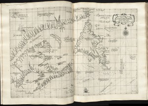
Chart of the Streights of Belle Isle
Chart of the Streights of Belle Isle
×
Item Information
Title:
Chart of the Streights of Belle Isle
Title (alt.):
Bay of Fundy
Publisher:
Norman, John, 1748?-1817
Date:
[1794]
Format:
Maps/Atlases
Location:
Boston Public Library
Norman B. Leventhal Map Center
Collection (local):
Norman B. Leventhal Map Center Collection
Subjects:
Coasts--Newfoundland and Labrador--Maps--Early works to 1800
Coasts--Nova Scotia--Maps--Early works to 1800
Coasts--Québec (Province)--Maps--Early works to 1800
Nautical charts--Belle Isle, Strait of (N.L.)--Early works to 1800
Nautical charts--Saint Lawrence, Gulf of--Early works to 1800
Belle Isle, Strait of (N.L.)--Maps--Early works to 1800
Newfoundland and Labrador--Maps--Early works to 1800
Québec (Province)--Maps--Early works to 1800
Saint Lawrence, Gulf of--Maps--Early works to 1800
Places:
Canada
>
Belle Isle, Strait of
Canada
>
Saint Lawrence, Gulf of
Extent:
1 map ; 51 x 41 cm
Permalink:
https://ark.digitalcommonwealth.org/ark:/50959/3f462z168
Terms of Use:
No known copyright restrictions.
No known restrictions on use.
Publisher:
[Boston] : [John Norman]
Scale:
Scale approximately 1:1,120,000
Language:
English
Notes:
Title from Wheat & Brun.
Depths shown by soundings.
In Norman's American pilot. Boston : John Norman, 1794.
Notes (date):
This date is inferred.
Identifier:
06_01_004807
Call #:
G1106.P5 N6 1794x
Barcode:
30000005058364
show more...
View MODS XML
More Like This
[Chart of the coast of Quebec from the Riviere St. Jean to Grand ...
Harbour and bay of Gaspee : Maul Bay
Carta particolare della terra nuoua con la Gran Baia et il Fiume ...
A chart of the Streights of Bell Isle
Find More Like This >>
Tools
Share
Facebook
Pinterest
X
Reddit
Tumblr
Email
Copy link
Add to Folder
Questions/Comments
Cite This Item
IIIF Manifest
Downloads
Primary (full resolution, uncompressed)
(TIF, 58.1 MB)
Large (full resolution)
(JPEG, 4.88 MB)
Medium
(JPEG, 179 KB)
![[Chart of the coast of Quebec from the Riviere St. Jean to Grand Hermine Bay]](https://bpldcassets.blob.core.windows.net/derivatives/images/commonwealth:7h149v50v/image_thumbnail_300.jpg)