Skip to search
Skip to main content
Digital Commonwealth
Sign Up / Log In
Search for
Search
Search
Search
Basic
Advanced
Explore
Map
Collections
Institutions
Formats
For Educators
Primary Source Sets
Lesson Plans
Using Primary Sources
Searching Digital Commonwealth
For Institutions
Join Digital Commonwealth
Conferences, Trainings, & Events
How to Contribute Collections
Digitization Services
Board & Committees
Frequently Asked Questions
About
About Digital Commonwealth
News & Announcements
Copyright & Terms of Use
Harmful Content Statement
Partners
API
Contact Us
Boston Public Library
Norman B. Leventhal Map Center Collection
/
Maritime Charts and Atlases (Collection of Distinction)
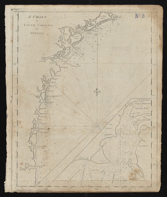
A chart of South Carolina and Georgia
A chart of South Carolina and Georgia
×
Item Information
Title:
A chart of South Carolina and Georgia
Creator:
Norman, John, 1748?-1817
Cartographer:
Norman, John, 1748?-1817
Publisher:
Norman, William, -1807
Date:
[1798]
Format:
Maps/Atlases
Location:
Boston Public Library
Norman B. Leventhal Map Center
Collection (local):
Norman B. Leventhal Map Center Collection
Subjects:
Coasts--Georgia--Maps--Early works to 1800
Coasts--South Carolina--Maps--Early works to 1800
Georgia--Maps--Early works to 1800
South Carolina--Maps--Early works to 1800
Charleston (S.C.)--Maps--Early works to 1800
Places:
Georgia
Charleston (county)
>
Charleston
Extent:
1 map ; 50 x 38 cm
Permalink:
https://ark.digitalcommonwealth.org/ark:/50959/3f462z478
Terms of Use:
No known copyright restrictions.
No known restrictions on use.
Publisher:
[Boston] : [William Norman]
Scale:
Scale approximately 1:625,000
Language:
English
Notes:
Depths shown by soundings.
Inset: A chart of the bar and harbour of Charles Town.
In Norman's The American pilot. Boston : William Norman, 1798.
Notes (date):
This date is inferred.
Identifier:
06_01_004838
Call #:
G1106.P5 N6 1798x
Barcode:
30000005069230
show more...
View MODS XML
More Like This
A chart of South Carolina and Georgia
A chart of South Carolina and Georgia
Chart of the coast of America from Cape Hateras to Cape Roman
Chart of the coast of America from Cape Hateras to Cape Roman
Find More Like This >>
Tools
Share
Facebook
Pinterest
X
Reddit
Tumblr
Email
Copy link
Add to Folder
Questions/Comments
Cite This Item
IIIF Manifest
Downloads
Primary (full resolution, uncompressed)
(TIF, 61.1 MB)
Large (full resolution)
(JPEG, 5.13 MB)
Medium
(JPEG, 204 KB)