Skip to search
Skip to main content
Digital Commonwealth
Sign Up / Log In
Search for
Search
Search
Search
Basic
Advanced
Explore
Map
Collections
Institutions
Formats
For Educators
Primary Source Sets
Lesson Plans
Using Primary Sources
Searching Digital Commonwealth
For Institutions
Join Digital Commonwealth
Conferences, Trainings, & Events
How to Contribute Collections
Digitization Services
Board & Committees
Frequently Asked Questions
About
About Digital Commonwealth
News & Announcements
Copyright & Terms of Use
Harmful Content Statement
Partners
API
Contact Us
Salem Public Library
Salem Maps
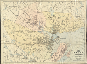
Map of Salem and Surrounding Places
View this item online at NOBLE Digital Heritage
Item Information
Title:
Map of Salem and Surrounding Places
Description:
Map of Salem and surrounding places in 1906, prepared and published for the Naumkeag Directory. Includes street detail for Salem, Beverly, Danvers and Marblehead. Digital copy available at the Norman B. Leventhal Map Center.
Creator:
Meek, Henry M.
Date:
1906
Format:
Maps/Atlases
Genre:
Cartographic
Location:
Salem Public Library
Collection (local):
Salem Maps
Places:
Massachusetts
>
Essex (county)
>
Salem
Massachusetts
>
Essex (county)
>
Beverly
Massachusetts
>
Essex (county)
>
Danvers
Massachusetts
>
Essex (county)
>
Marblehead
Link to Item:
https://omeka-s.noblenet.org/s/salem/item/11603
Terms of Use:
No copyright restrictions.
Contact host institution for more information.
Publisher:
Henry M. Meek Publishing Co. Salem, Mass
Language:
English
Notes:
Information about this item was supplied by NOBLE Digital Heritage.
Norman B. Leventhal Map Center
show more...
View MODS XML
More Like This
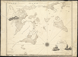
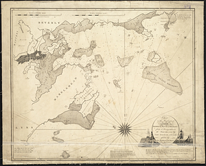
Chart of the harbours of Salem, Marblehead, Beverly, and ...
Chart of the harbours of Salem, Marblehead, Beverly, and ...
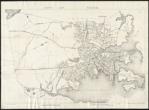
City of Salem
[Map of Salem, Mass.]
Find More Like This >>
Tools
Share
Facebook
Pinterest
X
Reddit
Tumblr
Email
Copy link
Add to Folder
Questions/Comments
Cite This Item
![[Map of Salem, Mass.]](https://bpldcassets.blob.core.windows.net/derivatives/metadata/commonwealth-oai:d504x457x/image_thumbnail_300.jpg)