Skip to search
Skip to main content
Skip to first result
Digital Commonwealth
Folders
Sign Up / Log In
Search for
Search
Search
Search
Basic
Advanced
Explore
Map
Collections
Institutions
Formats
For Educators
Primary Source Sets
Lesson Plans
Using Primary Sources
Searching Digital Commonwealth
For Institutions
Join Digital Commonwealth
Conferences, Trainings, & Events
How to Contribute Collections
Digitization Services
Board & Committees
Frequently Asked Questions
About
About Digital Commonwealth
News & Announcements
Copyright & Terms of Use
Harmful Content Statement
Partners
API
Contact Us
Search
Search Constraints
Start Over
Save Search
Your search:
More Like
commonwealth:hq37vv66t
✖
Remove constraint More Like: commonwealth:hq37vv66t
« Prev. |
1
-
100
of
165
|
Next »
Sort
by relevance
relevance
title
date (asc)
date (desc)
Number of results to display per page
100
per page
per page
10
per page
20
per page
50
per page
100
per page
View results as:
List
list view
Maps
map view
Gallery
grid view
Search Results
1.
Typus orbis terrarum
2.
Airways of the world on Mercator's projection
3.
American Radiator Company trade card
4.
Bartholomew's chart of the world on Mercator's projection
5.
Caerte van de voornaemste reysen ende ontdeckingen door de Hollanders gedaen, alsook vande landen, plaetsen ende factoriën in...
6.
Carriers of the new black plague
7.
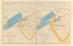
Carte figurative et approximative des quantités de coton en laine importées en Europe en 1858 et en 1861
8.
[Carte marine de la mer Baltique, de la mer du Nord, de l'océan Atlantique Est, de la mer Méditerranée, de la mer Noire et...
9.
A chart of the world, according to Mercators projection, shewing the latest discoveries of Capt. Cook
10.
Chart of the world, on Mercator's projection : illustrative of the impolicy of slavery
11.
Chart of the world showing area in the Pacific Ocean having Hawaii as the only base of supplies in transpacific voyages and...
12.
Chikyū bankoku hōzu
13.
Comparative view of the heights of the principal mountains &c. in the world
14.
Diagram to illustrate contrast between British and Chinese Empires
15.
Diqiu quan tu
16.
Eight views of the world
17.
Europe in search of new routes to India and China, 1486-1616 A.D.
18.
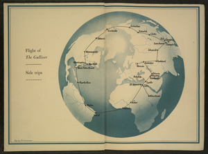
Flight of "The Gulliver"
19.
Gleason's new standard map of the world : on the projection of J. S. Christopher, Modern College, Blackheath, England ;...
20.
Great circle airways
21.
Imperial Federation, map of the world showing the extent of the British Empire in 1886
22.
Index diagram of sheets for the International map on the scale of 1:1,000,000
23.
Invasion and total war victory maps : with decorations, illustrations and military and naval insignia
24.
Kaufmännische wandkarte der erde zur übersicht der handelsbeziehungen, dampfer- und kabel-verbindungen des Deutschen Reiches...
25.
Magnetic variation chart for the year 1882
26.
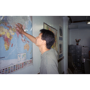
Man looking at wall map
27.
Map no. 245
28.
Map of Boston and adjacent country showing that city to be the geographical as well as intellectual and moral centre of one...
29.
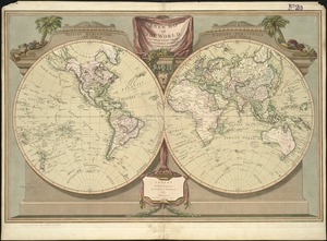
A map of the world
30.
[Map of the world]
31.
Map of the world
32.
A map of the world from the best authorities
33.
[Map of the world on a polyconic projection]
34.
Map of the world, on Mercator's projection
35.
Map of the world on Mercator's projection, to show the populations and actual areas occupied by the various states represented...
36.
Map of the world, shewing the tracks & discoveries of Captn. Cook
37.
Map showing the telegraph lines in operation, under contract, and contemplated, to complete the circuit of the globe
38.
Map showing the telegraph lines in operation, under contract, and contemplated, to complete the circuit of the globe
39.
Mappemonde projetée sur l'horizon d'Angers
40.
Mercator map of the world
41.
Mercator map of the world united : a pictorial history of transport and communications and paths to permanent peace
42.
[Mid]dleton's [pione]er map of the [w]orld, [as a?] plane and immoveable
43.
New correct map of the flat surface, stationary earth
44.
The new Europe and the new world
45.
The new map of the world
46.
A new map of the world according to Wrights alias Mercators projection &c : drawn from the newest and the most exact...
47.
A new map of the world, with Captain Cook's tracks, his discoveries and those of the other circumnavigators
48.
Newsmap : week of October 14 to October 21, 215th week of the war, 97th week of U.S. participation. Monday, October 25, 1943
49.
The official map of the world : showing the four quarters of the globe on the quarter-spherical or orange peel projection
50.
Orbis veteribus notus scilicet: Europe, Asia, Africa publici juris factus
51.
P. McD. Collins' proposed overland telegraph : via Behrings Strait and asiatic Russia to Europe, under Russian & British grants
52.
Peace map of the world united : a pictorial history of transportation and communications from Jonah to the jet plane as paths...
53.
Peters World map
54.
The pictorial map, a world of stamps
55.
A pictorial stamp map of navigation and exploration
56.
Political map of the world, April 2001
57.
The population map
58.
Racing routes of the Yankee clippers
59.
A shared problem, an unequal burden : causes & consequences of climate change
60.
Small circular world map
61.
Spherical projection world
62.
Stanford's library map of the world on Mercator's projection
63.
The story map of flying : being a chronicle of man's conquest of the air
64.
Submarine cable chart of the world : showing also the seacoast stations and the principal connecting land lines ; for the use...
65.
Total war battle map
66.
Typo de la carta cosmographica de Gaspar Vopellio Medeburgense
67.
[Universal map of China]
68.
Unsigned and untitled T-O world map
69.
What's up? South! : world map
70.
The world
71.
The World
72.
The world according to Standard (N.J.)
73.
World freedom : a factual & pictorial map
74.
[World map]
75.
The world, on Mercator's projection : showing the different routes to California, and distance by each; routes of different...
76.
The World, on the globular projection with a graduation for the measurement of distances especially adapted for the use oe...
77.
The world turned upside down
78.
The world upon globular projection and with a gazetteer of information
79.
World wonders : a pictorial map
80.
An accurate map of Rhode Island, part of Connecticut and Massachusets, shewing Admiral Arbuthnot's station in blocking up...
81.
An accurate map of the English colonies in North America, bordering on the river Ohio
82.
America
83.
America sive India Nova : ad magnae Gerardi Mercatoris aui universalis imitationem in compendium redacta
84.
America sive novvs orbis respectv Evropaeorvm inferior globi terrestris pars
85.
Americae pars Borealis, Florida, Baccalaos, Canada, Corterealis
86.
Americae siue noui orbis, noua descriptio
87.
Americae siue noui orbis, noua descriptio
88.
The American Atlas or, A Geographical Description of the whole continent of America : wherein are delineated at large, its...
89.
The American pilot : containing the navigation of the sea coat of North America . . .
90.
Atlantic Ocean
91.
L'Atlas de mer ou monde aquatique, remontrant toutes les côtes de la mer, a scavoir de la partie connuë de I'Univers, avec une...
92.
Barnstable County, Dukes County and Nantucket Island, Massachusetts
93.
Baye et port d'Yorc, capitale de la Nouvelle Yorc
94.
Bowles's new pocket map of the most inhabited part of New England : comprehending the provinces of Massachusets Bay and New...
95.
Carta marina nova tabula
96.
Carte de la Nouvelle Angleterre, New York, Pensilvanie et Nouveau Jersay suivant les cartes angloises
97.
Carte de la Nouvelle Angleterre, Nouvelle York, Nouvelle Jersey et Pensilvanie
98.
Chart and plan of the harbour of New York & the couny. adjacent, from Sandy Hook to Kingsbridge, comprehending the whole of New...
99.
Chart for the journal of Mr. le Mquis. de Chastellux
100.
A chart of the gulf stream
« Previous
Next »
1
2
Limit your search
Subject
World maps
79
New England--Maps--Early works to 1800
15
World maps--Early works to 1800
13
America--Maps--Early works to 1800
9
Massachusetts--Maps
8
North America--Maps--Early works to 1800
8
Pictorial maps
8
Western Hemisphere--Maps--Early works to 1800
6
more
Subject
»
Place
World
76
North and Central America
47
New England
20
United States
18
Massachusetts
17
Rhode Island
8
New York
7
Connecticut
6
more
Place
»
Format
Maps/Atlases
164
Manuscripts
2
Books
1
Photographs
1
Available to use
No known restrictions
68
Creative Commons license
1
Date
View distribution
Current results range from
1482
to
2022
Date range begin
Date range end
View larger »
Collection
Sidney R. Knafel Map Collection at Phillips Academy
87
Norman B. Leventhal Map Center Collection
77
American Revolutionary War-Era Maps (Collection of Distinction)
26
Boston and New England Maps (Collection of Distinction)
1
Chinese Progressive Association Records
1
Urban Maps (Collection of Distinction)
1
Institution
Phillips Academy
87
Boston Public Library
77
Northeastern University Library
1


![[Carte marine de la mer Baltique, de la mer du Nord, de l'océan Atlantique Est, de la mer Méditerranée, de la mer Noire et de la mer Rouge]](https://bpldcassets.blob.core.windows.net/derivatives/images/commonwealth:4m90fm28z/image_thumbnail_300.jpg)


![[Map of the world]](https://bpldcassets.blob.core.windows.net/derivatives/images/commonwealth:79408320r/image_thumbnail_300.jpg)


![[Map of the world on a polyconic projection]](https://bpldcassets.blob.core.windows.net/derivatives/images/commonwealth:x633f979b/image_thumbnail_300.jpg)


![[Mid]dleton's [pione]er map of the [w]orld, [as a?] plane and immoveable](https://bpldcassets.blob.core.windows.net/derivatives/images/commonwealth:7h149v84p/image_thumbnail_300.jpg)


![[Universal map of China]](https://bpldcassets.blob.core.windows.net/derivatives/images/commonwealth:qb98n8079/image_thumbnail_300.jpg)


![[World map]](https://bpldcassets.blob.core.windows.net/derivatives/images/commonwealth:x059cd25x/image_thumbnail_300.jpg)

![The World, on the globular projection with a graduation for the measurement of distances especially adapted for the use oe [sic] schools, geographical & historical lectures, and missionary meetings](https://bpldcassets.blob.core.windows.net/derivatives/images/commonwealth:ww72bp12b/image_thumbnail_300.jpg)


