Skip to search
Skip to main content
Digital Commonwealth
Sign Up / Log In
Search for
Search
Search
Search
Basic
Advanced
Explore
Map
Collections
Institutions
Formats
For Educators
Primary Source Sets
Lesson Plans
Using Primary Sources
Searching Digital Commonwealth
For Institutions
Join Digital Commonwealth
Conferences, Trainings, & Events
How to Contribute Collections
Digitization Services
Board & Committees
Frequently Asked Questions
About
About Digital Commonwealth
News & Announcements
Copyright & Terms of Use
Harmful Content Statement
Partners
API
Contact Us
Boston Public Library
Norman B. Leventhal Map & Education Center Collection
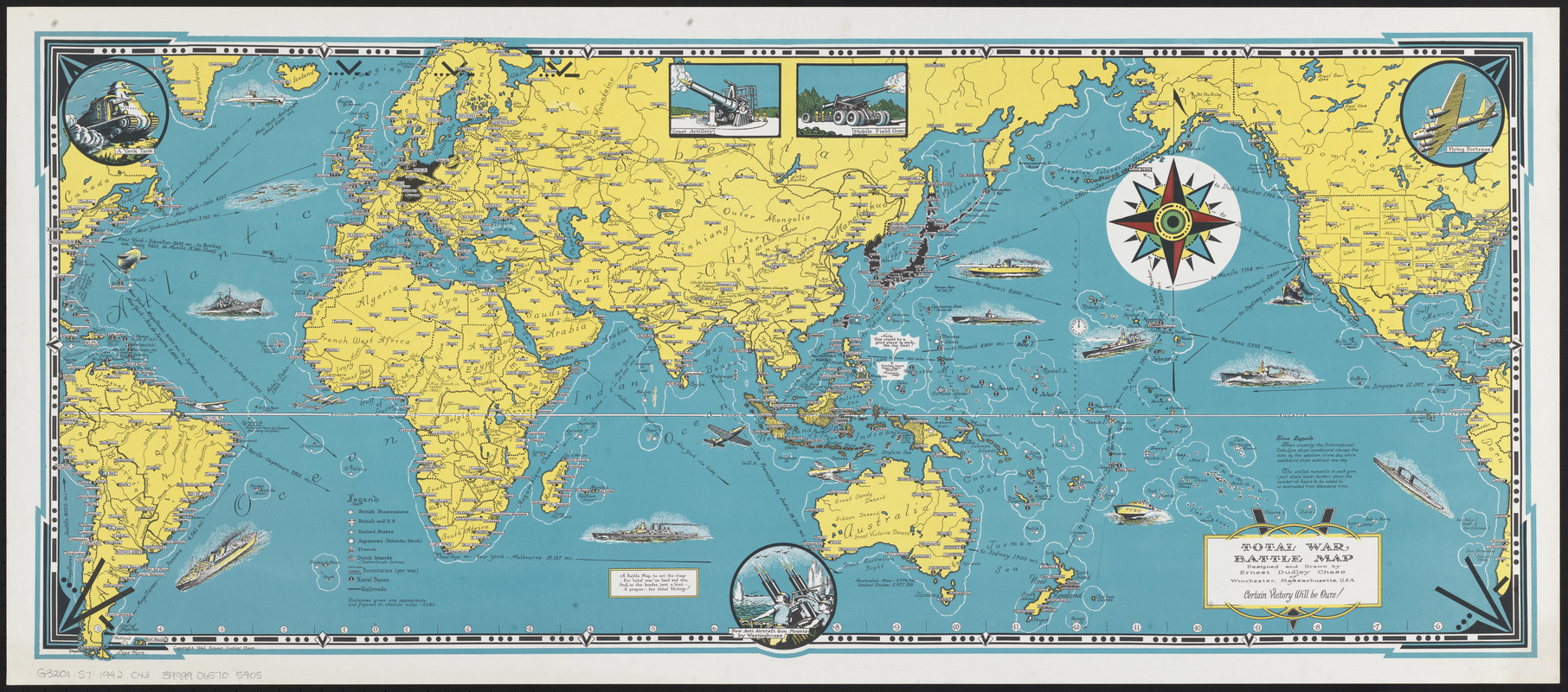
Total war battle map
Total war battle map
×
Item Information
Title:
Total war battle map
Creator:
Chase, Ernest Dudley, 1878-
Artist:
Chase, Ernest Dudley, 1878-
Cartographer:
Chase, Ernest Dudley, 1878-
Name on Item:
designed and drawn by Ernest Dudley Chase of Winchester, Massachusetts, U.S.A.
Date:
1942
Format:
Maps/Atlases
Location:
Boston Public Library
Norman B. Leventhal Map & Education Center
Collection (local):
Norman B. Leventhal Map & Education Center Collection
Subjects:
World War, 1939-1945--Maps
Pictorial maps
World maps
Places:
World
Extent:
1 map : color ; 36 x 87 cm
Permalink:
https://ark.digitalcommonwealth.org/ark:/50959/q524n3516
Terms of Use:
No known copyright restrictions.
No known restrictions on use.
Publisher:
[Winchester, Massachusetts] : [Ernest Dudley Chase]
Scale:
Scale not given
Language:
English
Notes:
Pictorial map.
Includes illustrations of artillery and vehicles.
Identifier:
06_01_014704
Call #:
G3201.S7 1942 .C43
Barcode:
39999065705905
show more...
View MODS XML
More Like This
Invasion and total war victory maps : with decorations, ...
Mercator map of the world united : a pictorial history of ...
The new map of the world
A pictorial stamp map of navigation and exploration
Find More Like This >>
Tools
Share
Facebook
Pinterest
X
Reddit
Tumblr
Email
Copy link
Add to Folder
Questions/Comments
Cite This Item
IIIF Manifest
Downloads
Primary (full resolution, uncompressed)
(TIF, 221 MB)
Large (full resolution)
(JPEG, 18.5 MB)
Medium
(JPEG, 807 KB)
We'd love your feedback!
×
Would you be interested in taking a short survey about Digital Commonwealth?