Skip to search
Skip to main content
Digital Commonwealth
Sign Up / Log In
Search for
Search
Search
Search
Basic
Advanced
Explore
Map
Collections
Institutions
Formats
For Educators
Primary Source Sets
Lesson Plans
Using Primary Sources
Searching Digital Commonwealth
For Institutions
Join Digital Commonwealth
Conferences, Trainings, & Events
How to Contribute Collections
Digitization Services
Board & Committees
Frequently Asked Questions
About
About Digital Commonwealth
News & Announcements
Copyright & Terms of Use
Harmful Content Statement
Partners
API
Contact Us
Boston Public Library
Norman B. Leventhal Map Center Collection
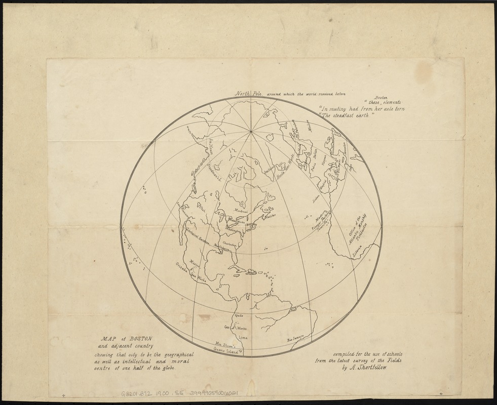
Map of Boston and adjacent country showing that city to be the geographical as well as intellectual and moral centre of one half of the globe
Map of Boston and adjacent country showing that city to be the geographical as well as intellectual and moral centre of one half of the globe
×
Item Information
Title:
Map of Boston and adjacent country showing that city to be the geographical as well as intellectual and moral centre of one half of the globe
Creator:
Shortfellow, A.
Name on Item:
compiled for the use of schools from the latest survey of the fields by A. Shortfellow.
Date:
[ca. 1871]
Format:
Maps/Atlases
Location:
Boston Public Library
Norman B. Leventhal Map Center
Collection (local):
Norman B. Leventhal Map Center Collection
Subjects:
Map projection--Maps
Maps in education--Massachusetts--Boston
Map reading--Massachusetts--Boston
World maps
Boston (Mass.)--Maps
Places:
World
Extent:
1 map ; 26 cm. in diam., on sheet 34 x 40 cm.
Permalink:
https://ark.digitalcommonwealth.org/ark:/50959/9s161j45n
Terms of Use:
No known copyright restrictions.
No known restrictions on use.
Publisher:
[Philadelphia] : [John Penington & Son]
Scale:
Scale not given.
Language:
English
Notes:
Relief shown pictorially.
Notes (citation):
The literary world, July 1, 1871, page 31
Identifier:
06_01_004312
Call #:
G3201.B72 1900 .S5
Barcode:
39999059006021
LCCN:
2001620545
show more...
View MODS XML
More Like This
Airways of the world on Mercator's projection
American Radiator Company trade card
Bartholomew's chart of the world on Mercator's projection
Caerte van de voornaemste reysen ende ontdeckingen door de ...
Find More Like This >>
Tools
Share
Facebook
Pinterest
X
Reddit
Tumblr
Email
Copy link
Add to Folder
Questions/Comments
Cite This Item
IIIF Manifest
Downloads
Primary (full resolution, uncompressed)
(TIF, 111 MB)
Large (full resolution)
(JPEG, 9.28 MB)
Medium
(JPEG, 187 KB)