Skip to search
Skip to main content
Digital Commonwealth
Sign Up / Log In
Search for
Search
Search
Search
Basic
Advanced
Explore
Map
Collections
Institutions
Formats
For Educators
Primary Source Sets
Lesson Plans
Using Primary Sources
Searching Digital Commonwealth
For Institutions
Join Digital Commonwealth
Conferences, Trainings, & Events
How to Contribute Collections
Digitization Services
Board & Committees
Frequently Asked Questions
About
About Digital Commonwealth
News & Announcements
Copyright & Terms of Use
Harmful Content Statement
Partners
API
Contact Us
Boston Public Library
Norman B. Leventhal Map Center Collection
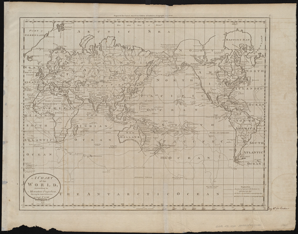
A chart of the world, according to Mercators projection, shewing the latest discoveries of Capt. Cook
A chart of the world, according to Mercators projection, shewing the latest discoveries of Capt. Cook
×
Item Information
Title:
A chart of the world, according to Mercators projection, shewing the latest discoveries of Capt. Cook
Engraver:
Barker, W. (William), active 1795-1803
Publisher:
Carey, Mathew, 1760-1839
Name on Item:
William Barker sculp.
Date:
[1800]
Format:
Maps/Atlases
Location:
Boston Public Library
Norman B. Leventhal Map Center
Collection (local):
Norman B. Leventhal Map Center Collection
Subjects:
World maps
Places:
World
Extent:
1 map ; 35 x 45 cm
Permalink:
https://ark.digitalcommonwealth.org/ark:/50959/3f463028f
Terms of Use:
No known copyright restrictions.
No known restrictions on use.
Publisher:
[Philadelphia] : [Mathew Carey]
Scale:
Scale approximately 1:82,000,000
Language:
English
Notes:
Shows tracks of Captain Cook's voyages.
Prime meridians: London and Philadelphia.
"Engraved for Carey's American edition of Guthrie's geography improved."
In upper right: 2.
Map 2 in his Carey's general atlas. Philadelphia : Mathew Carey, 1800.
Notes (date):
This date is inferred.
Identifier:
06_01_004521
Call #:
G1015 .C3 1800x
Barcode:
30000005056001
show more...
View MODS XML
More Like This
Airways of the world on Mercator's projection
American Radiator Company trade card
Bartholomew's chart of the world on Mercator's projection
Caerte van de voornaemste reysen ende ontdeckingen door de ...
Find More Like This >>
Tools
Share
Facebook
Pinterest
X
Reddit
Tumblr
Email
Copy link
Add to Folder
Questions/Comments
Cite This Item
IIIF Manifest
Downloads
Primary (full resolution, uncompressed)
(TIF, 54.2 MB)
Large (full resolution)
(JPEG, 4.55 MB)
Medium
(JPEG, 316 KB)