Skip to search
Skip to main content
Digital Commonwealth
Sign Up / Log In
Search for
Search
Search
Search
Basic
Advanced
Explore
Map
Collections
Institutions
Formats
For Educators
Primary Source Sets
Lesson Plans
Using Primary Sources
Searching Digital Commonwealth
For Institutions
Join Digital Commonwealth
Conferences, Trainings, & Events
How to Contribute Collections
Digitization Services
Board & Committees
Frequently Asked Questions
About
About Digital Commonwealth
News & Announcements
Copyright & Terms of Use
Harmful Content Statement
Partners
API
Contact Us
Boston Public Library
Norman B. Leventhal Map & Education Center Collection
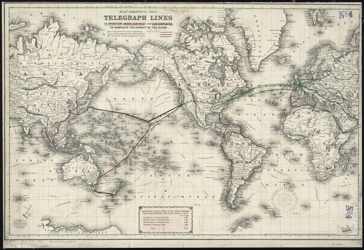
Map showing the telegraph lines in operation, under contract, and contemplated, to complete the circuit of the globe
Map showing the telegraph lines in operation, under contract, and contemplated, to complete the circuit of the globe
×
Item Information
Title:
Map showing the telegraph lines in operation, under contract, and contemplated, to complete the circuit of the globe
Creator:
J.H. Colton & Co
Date:
[1871]
Format:
Maps/Atlases
Location:
Boston Public Library
Norman B. Leventhal Map & Education Center
Collection (local):
Norman B. Leventhal Map & Education Center Collection
Subjects:
Telegraph lines--Maps
World maps
Places:
World
Extent:
1 map : hand col. ; 41 x 63 cm.
Permalink:
https://ark.digitalcommonwealth.org/ark:/50959/7h149w171
Terms of Use:
No known copyright restrictions.
No known restrictions on use.
Publisher:
New York : G.W. & C.B. Colton & Co.
Scale:
Scale [ca. 1:75,000,000]. At equator
Language:
English
Notes:
Relief shown by hachures.
Includes cable route distance chart.
Entered according to act of congress ... 1855 by J.H. Colton & Co.
Similar to 1855 version but lacks note and includes distance table.
Notes (date):
This date is inferred.
Identifier:
06_01_008395
Call #:
G3201.P92 1871 .J53
Barcode:
39999065653501
LCCN:
86692708
show more...
View MODS XML
More Like This
Map showing the telegraph lines in operation, under contract, and ...
P. McD. Collins' proposed overland telegraph : via Behrings Strait ...
Submarine cable chart of the world : showing also the seacoast ...
Carte des communications télégraphiques du régime extra-européen
Find More Like This >>
Tools
Share
Facebook
Pinterest
X
Reddit
Tumblr
Email
Copy link
Add to Folder
Questions/Comments
Cite This Item
IIIF Manifest
Downloads
Primary (full resolution, uncompressed)
(TIF, 93.2 MB)
Large (full resolution)
(JPEG, 7.83 MB)
Medium
(JPEG, 426 KB)