Skip to search
Skip to main content
Skip to first result
Digital Commonwealth
Folders
Sign Up / Log In
Search for
Search
Search
Search
Basic
Advanced
Explore
Map
Collections
Institutions
Formats
For Educators
Primary Source Sets
Lesson Plans
Using Primary Sources
Searching Digital Commonwealth
For Institutions
Join Digital Commonwealth
Conferences, Trainings, & Events
How to Contribute Collections
Digitization Services
Board & Committees
Frequently Asked Questions
About
About Digital Commonwealth
News & Announcements
Copyright & Terms of Use
Harmful Content Statement
Partners
API
Contact Us
Search
Search Constraints
Start Over
Save Search
Your search:
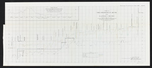
More Like
commonwealth:cj82kt994
✖
Remove constraint More Like: commonwealth:cj82kt994
« Prev. |
1
-
100
of
11,143
|
Next »
Sort
by relevance
relevance
title
date (asc)
date (desc)
Number of results to display per page
100
per page
per page
10
per page
20
per page
50
per page
100
per page
View results as:
List
list view
Maps
map view
Gallery
grid view
Search Results
1.
The city of New York as laid out by the Commissioners with the surrounding country
2.
A map of Massachusetts, Connecticut and Rhodeisland
3.
Map of Massachusetts, Rhode-Island & Connecticut : compiled from the latest authorities
4.
Massachusetts, Rhode-Island and Connecticut
5.
The National Publishing Company's railroad, post office, township and county map of Massachusetts, Rhode Island and Connecticut...
6.
Sketch of the states of Massachusetts, Connecticut, and Rhode Island, and parts of New Hampshire & New York exhibiting the...
7.
Sketch of the states of Massachusetts, Connecticut, and Rhode Island, and parts of New Hampshire & New York exhibiting the...
8.
Map of the southern part of New England : compiled for Pres't. Dwights travels
9.
Johnson's Massachusetts Connecticut and Rhode Island
10.
Map of Massachusetts, Connecticut and Rhode Island constructed from the latest authorities
11.
Map of Massachusetts, Connecticut and Rhode Island constructed from the latest authorities
12.
Map of Massachusetts, Rhode-Island & Connecticut : compiled from the latest authorities
13.
Massachusetts with Connecticut and Rhode Island
14.
Post route map of the states of Massachusetts, Rhode Island, Connecticut showing post offices with the intermediate distances...
15.
County Map of the States of New York, New Hampshire, Vermont, Massachusetts, Rhode Island, and Connecticut.
16.
States of Massachusetts, Rhode Island and Connecticut : shaded relief
17.
States of Massachusetts, Rhode Island and Connecticut : base map with highways and contours
18.
States of Massachusetts, Rhode Island and Connecticut : base map with highways and contours
19.
Tunison's Massachusetts, Connecticut and Rhode Island
20.
Atlas Maps of Massachusetts, Connecticut and Rhode Island, from the Latest Official Surveys.
21.
Connecticut with portions of New York & Rhode Island
22.
Manuscript maps of U.S. states
23.
Colton's Massachusetts and Rhode Island
24.
Hammond's new road map of Rhode Island and southeastern Massachusetts
25.
Map of Massachusetts and Rhode Island
26.
National topographic map of Massachusetts and Rhode Island : showing counties, townships, cities, villages and post offices ......
27.
New York, New Haven & Hartford Railroad : Old Colony system
28.
Route of the proposed Providence & Worcester rail-road
29.
Route of the Providence and Worcester rail road
30.
Topographic map of Massachusetts and Rhode Island
31.
Tri-state trolley map showing Boston & Northern and Old Colony Street Railway Companies' systems and connecting lines
32.
G. Woolworth Colton's railroad, township & distance map of New England with adjacent portions of New York, Canada & New Brunswick
33.
Map of the country copied from Hale's map of N. E. with railroad route from Boston to Lake Champlain : through Keene, N. H
34.
Map of the rail road from Boston to Stanstead
35.
A Map of Connecticut and Rhode Island, with Long Island Sound, &c
36.
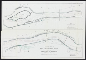
Resurvey of the Connecticut River, 1897. Plate I: Between Enfield Dam and Hartford. Sheet 1
37.
Resurvey of the Connecticut River, 1897. Plate II: between Enfield Dam and Hartford. Sheet 2
38.
Resurvey of the Connecticut River, 1897. Plate III: between Enfield Dam and Hartford. Sheet 3
39.
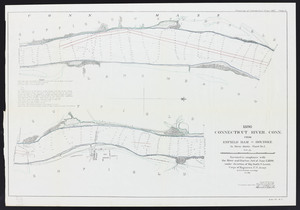
Resurvey of the Connecticut River, 1897. Plate IV: from Enfield Dam to Holyoke. Sheet 1
40.
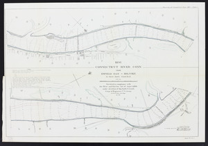
Resurvey of the Connecticut River, 1897. Plate V: from Enfield Dam to Holyoke. Sheet 2
41.
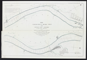
Resurvey of the Connecticut River, 1897. Plate VI: from Enfield Dam to Holyoke. Sheet 3
42.
Resurvey of the Connecticut River, 1897. Plate VII: Profile of the Connecticut River from Hartford to Holyoke
43.
Massachusetts and Rhode Island
44.
Massachusetts and Rhode Island
45.
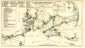
U.S. River & Harbor Improvements: In Charge of Captain W.H. Bixby, Corps of Engineers, U.S.A., 1893
46.
The Commonwealth of Connecticut
47.
Connecticut
48.
Connecticut
49.
Connecticut
50.
Connecticut
51.
Connecticut, from actual survey
52.
Connecticut from the best authorities
53.
Manuscript maps of U.S. states, possibly drawn by a schoolchild
54.
Map of Connecticut
55.
Preliminary geological map of Connecticut
56.
The state of New York with part of the adjacent states
57.
Geographical, statistical, and historical map of Rhode Island
58.
A map of the State of Rhode Island
59.
Map of the State of Rhode Island and Providence Plantations
60.
Map of the State of Rhode Island, and Providence Plantations
61.
Rhode Island
62.
Rhode Island
63.
Rhode Island
64.
The state of Rhode Island
65.
The state of Rhode Island : compiled from the surveys and observations of Caleb Harris
66.
Topographical map of the state of Rhode Island and Providence plantations
67.
A topographical map of the state of Rhode-Island and Providence Plantations
68.
ABC pathfinder railway guide map : eastern division
69.
Automobile map of New England showing the ideal tour
70.
Boston Clinton Fitchburg and Mansfield Framingham Lowell Railroads, and connections
71.
The Boston Globe ski map of northern New England and Canada
72.
A canoeist's guide to New England's rivers
73.
C.H. Guild & Co.'s newspaper map of New England
74.
Commercial map of New England
75.
Ensign, Bridgman & Fanning's rail road map of the United States, showing the depots & stations
76.
E.P. Dutton & Co.'s railroad, steam boat & stage route map of New England, New-York and Canada
77.
Fishing grounds out of Boston : NLSECO marine diesel oil engines ; built by New London Ship & Engine Co., Groton, Conn
78.
G. Woolworth Colton's railroad, township & distance map of New England : with adjacent portions of New York, Canada & New...
79.
The heart of New England
80.
Hodgman's new map showing location and classification golf and country clubs of New England with automobile roads and distances
81.
Industrial map of New England
82.
Kaart van Nieuw Nederland : behoorende tot de door het Provinciaal Utrechtsch genootschap bekroonde verhandeling
83.
Limited edition, 500 only of a pictorial map covering the New England States U.S.A
84.
Lloyd's railroad, telegraph & express map of the Eastern States to accompany Lloyd's railroad, telegraph & express map of the...
85.
Map exhibiting the rail road, canal, lake and river routes from New York and Boston to the west, via Ogdensburgh, Buffalo and...
86.
Map exhibiting the rail road routes leading from Boston, to Ogdensburg and Buffalo, N.Y
87.
Map first division railway mail service
88.
Map of Maine, New Hampshire, and Vermont : compiled from the latest authorities
89.
Map of Maine, New Hampshire and Vermont, from the most authentic sources
90.
Map of Maine, New Hampshire, Vermont, Massachusetts, Rhode Island, and Connecticut : exhibiting the post offices, post roads,...
91.
Map of New England
92.
Map of New England : with adjacent portions of New York & Canada
93.
[Map of New England, 31st]
94.
Map of New England exhibiting the rail road & telegraphic lines now in operation
95.
Map of New England exhibiting the rail road and telegraphic lines now in operation
96.
Map of New England with adjacent portions of New York & Canada
97.
Map of New England with adjacent portions of New York & Canada
98.
Map of New England with adjacent portions of New York & Canada
99.
Map of the Boston & Maine Railroad, showing its relative position & connection with other railroads
100.
Map of the Boston and Northwestern, Massachusetts Central, and Boston and Poughkeepsie Railroads and their connections
« Previous
Next »
1
2
3
4
5
…
111
112
Limit your search
Subject
Real property--Massachusetts--Boston--Maps
2,278
Landowners--Massachusetts--Boston--Maps
2,117
Boston (Mass.)--Maps
1,976
Roxbury (Boston, Mass.)--Maps
351
Dorchester (Boston, Mass.)--Maps
317
Massachusetts--Maps
271
Cambridge (Mass.)--Maps
266
Brookline (Mass.)--Maps
236
more
Subject
»
Place
North and Central America
7,950
United States
6,539
Suffolk (county)
3,349
Massachusetts
3,276
Boston
3,209
Europe
963
Middlesex (county)
617
Canada
432
more
Place
»
Format
Maps/Atlases
11,083
Manuscripts
217
Prints
51
Books
36
Objects/Artifacts
10
Drawings/Illustrations
8
Posters
4
Available to use
No known restrictions
10,965
Creative Commons license
51
Date
View distribution
Current results range from
1482
to
2023
Date range begin
Date range end
View larger »
Unknown
2
Collection
Norman B. Leventhal Map Center Collection
11,033
Boston and New England Maps (Collection of Distinction)
5,142
Urban Maps (Collection of Distinction)
4,847
Maritime Charts and Atlases (Collection of Distinction)
750
American Revolutionary War-Era Maps (Collection of Distinction)
637
Boston Redevelopment Authority Collection
89
Historic Maps
39
David Judkins Weaver Papers
22
more
Collection
»
Institution
Boston Public Library
11,033
Salem State University Archives and Special Collections
39
State Library of Massachusetts
33
American Antiquarian Society
18
Phillips Academy
11
Private Collection
3
Jones Library, Amherst
2
Massachusetts Historical Society
2
more
Institution
»


![[Map of New England, 31st]](https://bpldcassets.blob.core.windows.net/derivatives/images/commonwealth:wd3763094/image_thumbnail_300.jpg)


