Skip to search
Skip to main content
Digital Commonwealth
Sign Up / Log In
Search for
Search
Search
Search
Basic
Advanced
Explore
Map
Collections
Institutions
Formats
For Educators
Primary Source Sets
Lesson Plans
Using Primary Sources
Searching Digital Commonwealth
For Institutions
Join Digital Commonwealth
Conferences, Trainings, & Events
How to Contribute Collections
Digitization Services
Board & Committees
Frequently Asked Questions
About
About Digital Commonwealth
News & Announcements
Copyright & Terms of Use
Harmful Content Statement
Partners
API
Contact Us
Boston Public Library
Norman B. Leventhal Map & Education Center Collection
/
Boston and New England Maps (Collection of Distinction)
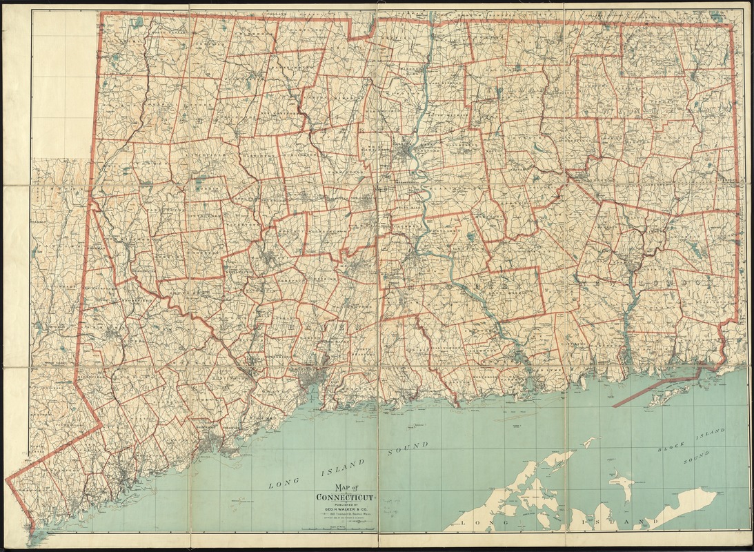
Map of Connecticut
Map of Connecticut
×
Item Information
Title:
Map of Connecticut
Creator:
Geo. H. Walker & Co
Date:
1893
Format:
Maps/Atlases
Location:
Boston Public Library
Norman B. Leventhal Map & Education Center
Collection (local):
Norman B. Leventhal Map & Education Center Collection
Subjects:
Roads--Connecticut--Maps
Connecticut--Maps
Places:
Connecticut
Extent:
1 map : col., dissected and mounted on linen ; 103 x 142 cm.
Permalink:
https://ark.digitalcommonwealth.org/ark:/50959/4m90f3668
Terms of Use:
No known copyright restrictions.
No known restrictions on use.
Publisher:
Boston : Geo. H. Walker & Co.
Scale:
Scale ca. [1:117,500]
Language:
English
Notes:
Relief shown by contours.
Shows town boundaries.
Identifier:
06_01_010838
Call #:
G3780 1893 .G46
Barcode:
39999065678326
show more...
View MODS XML
More Like This
74 miles on the ocean scenic highway U.S. 1
The city of New York as laid out by the Commissioners with the ...
The Commonwealth of Connecticut
Connecticut
Find More Like This >>
Tools
Share
Facebook
Pinterest
X
Reddit
Tumblr
Email
Copy link
Add to Folder
Questions/Comments
Cite This Item
IIIF Manifest
Downloads
Primary (full resolution, uncompressed)
(TIF, 370 MB)
Large (full resolution)
(JPEG, 31.1 MB)
Medium
(JPEG, 439 KB)
GeoTIFF (georeferenced)
(TIF, 490 MB)