Skip to search
Skip to main content
Digital Commonwealth
Sign Up / Log In
Search for
Search
Search
Search
Basic
Advanced
Explore
Map
Collections
Institutions
Formats
For Educators
Primary Source Sets
Lesson Plans
Using Primary Sources
Searching Digital Commonwealth
For Institutions
Join Digital Commonwealth
Conferences, Trainings, & Events
How to Contribute Collections
Digitization Services
Board & Committees
Frequently Asked Questions
About
About Digital Commonwealth
News & Announcements
Copyright & Terms of Use
Harmful Content Statement
Partners
API
Contact Us
Boston Public Library
Norman B. Leventhal Map & Education Center Collection
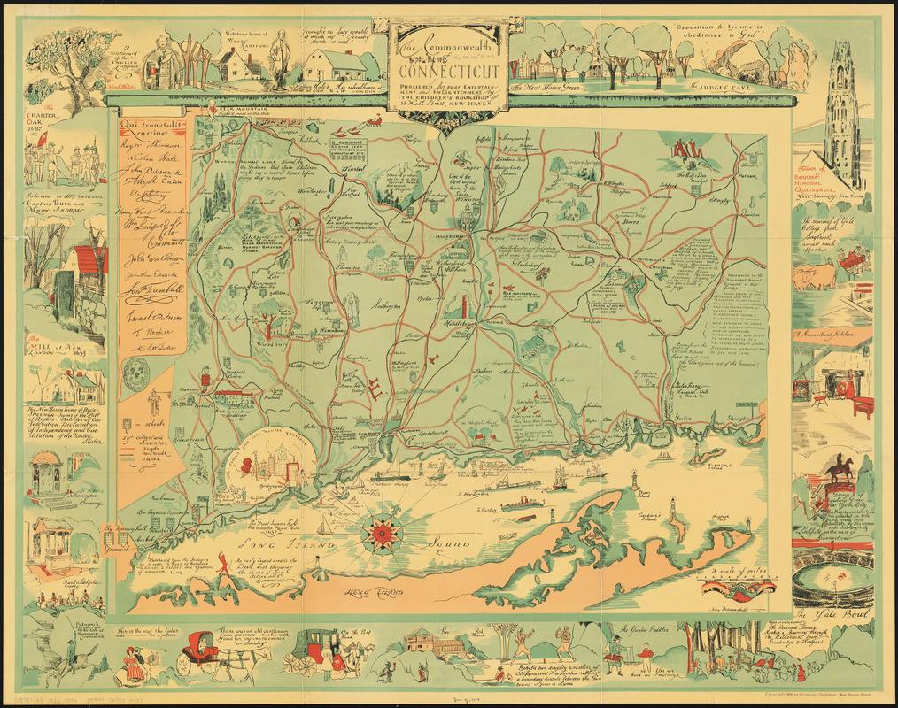
The Commonwealth of Connecticut
The Commonwealth of Connecticut
×
Item Information
Title:
The Commonwealth of Connecticut
Creator:
Drevenstedt, Amy
Cartographer:
Drevenstedt, Amy
Name on Item:
Amy Drevenstedt
Date:
1926
Format:
Maps/Atlases
Location:
Boston Public Library
Norman B. Leventhal Map & Education Center
Collection (local):
Norman B. Leventhal Map & Education Center Collection
Subjects:
Connecticut--Maps
Pictorial maps
Places:
Connecticut
Extent:
1 map : color ; 54 x 73 cm, on sheet 74 x 95 cm.
Permalink:
https://ark.digitalcommonwealth.org/ark:/50959/3f4638283
Terms of Use:
No known copyright restrictions.
No known restrictions on use.
Publisher:
New Haven, Connecticut : Children's Bookshop
Scale:
Scale approximately 1:187,000
Language:
English
Notes:
Amy Drevenstedt ---26.
Land forms shown pictorially.
Shows roads, railroads, rivers, colleges and universities.
Includes text and illustrations
Illustrations and text in border.
Identifier:
06_01_014647
Call #:
G3781.A5 1926 .D74
Barcode:
39999065704437
show more...
View MODS XML
More Like This
74 miles on the ocean scenic highway U.S. 1
The city of New York as laid out by the Commissioners with the ...
Connecticut
Connecticut
Find More Like This >>
Tools
Share
Facebook
Pinterest
X
Reddit
Tumblr
Email
Copy link
Add to Folder
Questions/Comments
Cite This Item
IIIF Manifest
Downloads
Primary (full resolution, uncompressed)
(TIF, 285 MB)
Large (full resolution)
(JPEG, 23.9 MB)
Medium
(JPEG, 484 KB)