Skip to search
Skip to main content
Digital Commonwealth
Sign Up / Log In
Search for
Search
Search
Search
Basic
Advanced
Explore
Map
Collections
Institutions
Formats
For Educators
Primary Source Sets
Lesson Plans
Using Primary Sources
Searching Digital Commonwealth
For Institutions
Join Digital Commonwealth
Conferences, Trainings, & Events
How to Contribute Collections
Digitization Services
Board & Committees
Frequently Asked Questions
About
About Digital Commonwealth
News & Announcements
Copyright & Terms of Use
Harmful Content Statement
Partners
API
Contact Us
Boston Public Library
Norman B. Leventhal Map & Education Center Collection
/
Boston and New England Maps (Collection of Distinction)
New York, New Haven & Hartford Railroad : Old Colony system
New York, New Haven & Hartford Railroad
×
Item Information
Title:
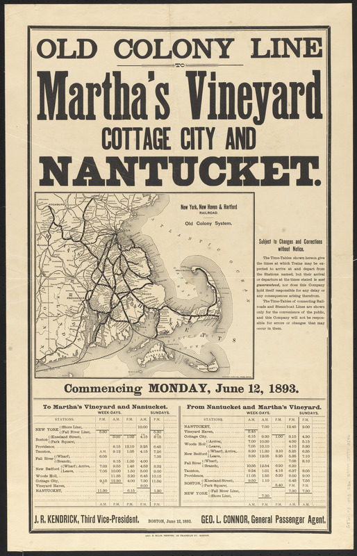
New York, New Haven & Hartford Railroad : Old Colony system
Title (alt.):
Old Colony system
Old Colony line to Martha's Vineyard Cottage City and Nantucket
Cartographer:
Rand Avery Supply Co.
Printer:
Ellis, George H. (Printer)
Name on Item:
Rand Avery Supply Co., engrs.
Date:
1893
Format:
Maps/Atlases
Location:
Boston Public Library
Norman B. Leventhal Map & Education Center
Collection (local):
Norman B. Leventhal Map & Education Center Collection
Subjects:
Old Colony Railroad Company--Timetables
Old Colony Railroad Company--Maps
Railroads--Massachusetts--Maps
Railroads--Rhode Island--Maps
Massachusetts--Maps
Rhode Island--Maps
Old Colony Railroad Company
New York, New Haven, and Hartford Railroad Company
Places:
Massachusetts
Rhode Island
Extent:
1 map ; 24 x 29 cm, on sheet 72 x 46 cm
Permalink:
https://ark.digitalcommonwealth.org/ark:/50959/0r96fp094
Terms of Use:
No known copyright restrictions.
No known restrictions on use.
Publisher:
Boston : Geo H. Ellis
Scale:
Scale approximately 1:700,000
Language:
English
Notes:
Map showing the Old Colony line in southeastern Massachusetts and Rhode Island, newly leased by the New York, New Haven & Hartford Railroad.
Includes text and time-tables commencing Monday, June 12, 1893.
Identifier:
06_01_016051
Call #:
G3761.P3 1893 .R36
Barcode:
39999085942546
show more...
View MODS XML
More Like This
Map of Massachusetts, Connecticut and Rhode Island constructed ...
Map of Massachusetts, Connecticut and Rhode Island constructed ...
Map of Massachusetts, Rhode-Island & Connecticut : compiled from ...
The National Publishing Company's railroad, post office, township ...
Find More Like This >>
Tools
Share
Facebook
Pinterest
X
Reddit
Tumblr
Email
Copy link
Add to Folder
Questions/Comments
Cite This Item
IIIF Manifest
Downloads
Primary (full resolution, uncompressed)
(TIF, 87.1 MB)
Large (full resolution)
(JPEG, 7.31 MB)
Medium
(JPEG, 207 KB)