Skip to search
Skip to main content
Digital Commonwealth
Sign Up / Log In
Search for
Search
Search
Search
Basic
Advanced
Explore
Map
Collections
Institutions
Formats
For Educators
Primary Source Sets
Lesson Plans
Using Primary Sources
Searching Digital Commonwealth
For Institutions
Join Digital Commonwealth
Conferences, Trainings, & Events
How to Contribute Collections
Digitization Services
Board & Committees
Frequently Asked Questions
About
About Digital Commonwealth
News & Announcements
Copyright & Terms of Use
Harmful Content Statement
Partners
API
Contact Us
Boston Public Library
Norman B. Leventhal Map Center Collection
/
Boston and New England Maps (Collection of Distinction)
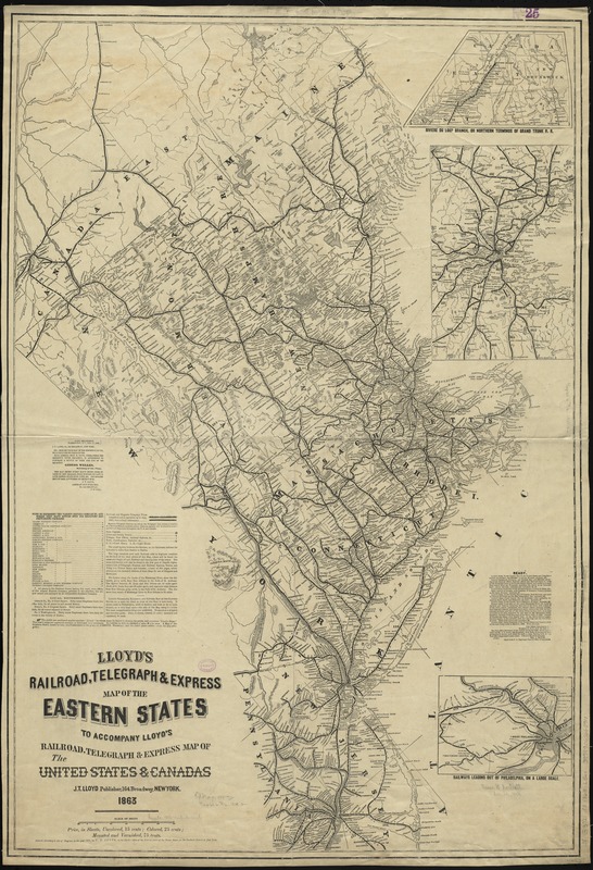
Lloyd's railroad, telegraph & express map of the Eastern States to accompany Lloyd's railroad, telegraph & express map of the United States & Canadas
Lloyds railroad, telegraph & express map of the Eastern States to accompany Lloyds railroad, telegraph & express map of the United States & Canadas
×
Item Information
Title:
Lloyd's railroad, telegraph & express map of the Eastern States to accompany Lloyd's railroad, telegraph & express map of the United States & Canadas
Creator:
Lloyd, James T.
Date:
1863
Format:
Maps/Atlases
Location:
Boston Public Library
Norman B. Leventhal Map Center
Collection (local):
Norman B. Leventhal Map Center Collection
Subjects:
Railroads--New England--Maps
Telegraph lines--New England--Maps
New England--Maps
Places:
New England
(area)
Extent:
1 map ; 96 x 66 cm.
Permalink:
https://ark.digitalcommonwealth.org/ark:/50959/cj82kn85r
Terms of Use:
No known copyright restrictions.
No known restrictions on use.
Publisher:
New York : J. T. Lloyd
Scale:
Scale [ca. 1:879,000]
Language:
English
Notes:
Oriented with north to the upper left.
Relief shown by hachures.
Insets: Riviere du Loup Branch, or northern terminus of Grand Trunk R. R. -- [Vicinity of Boston] -- Railways leading out of Philadelphia, on a large scale.
Identifier:
06_01_009200
Call #:
G3721.P3 1863 .L56x
Barcode:
39999065660910
show more...
View MODS XML
More Like This
Map of New England exhibiting the rail road & telegraphic lines ...
Map of New England exhibiting the rail road and telegraphic lines ...
Telegraph and rail road map of the New England states
Williams' telegraph and rail road map of the New England states, ...
Find More Like This >>
Tools
Share
Facebook
Pinterest
X
Reddit
Tumblr
Email
Copy link
Add to Folder
Questions/Comments
Cite This Item
IIIF Manifest
Downloads
Primary (full resolution, uncompressed)
(TIF, 248 MB)
Large (full resolution)
(JPEG, 20.8 MB)
Medium
(JPEG, 218 KB)