Skip to search
Skip to main content
Digital Commonwealth
Sign Up / Log In
Search for
Search
Search
Search
Basic
Advanced
Explore
Map
Collections
Institutions
Formats
For Educators
Primary Source Sets
Lesson Plans
Using Primary Sources
Searching Digital Commonwealth
For Institutions
Join Digital Commonwealth
Conferences, Trainings, & Events
How to Contribute Collections
Digitization Services
Board & Committees
Frequently Asked Questions
About
About Digital Commonwealth
News & Announcements
Copyright & Terms of Use
Harmful Content Statement
Partners
API
Contact Us
Boston Public Library
Norman B. Leventhal Map & Education Center Collection
/
Boston and New England Maps (Collection of Distinction)
Williams' telegraph and rail road map of the New England states, eastern portion of New York state and Canada
Williams telegraph and rail road map of the New England states, eastern portion of New York state and Canada
×
Item Information
Title:
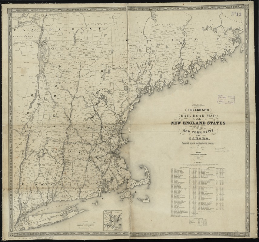
Williams' telegraph and rail road map of the New England states, eastern portion of New York state and Canada
Title (alt.):
Telegraph and rail road map of the New England states, eastern portion of New York state and Canada
Creator:
Williams, Alexander.
Name on Item:
compiled from the most authentic sources by Alexander Williams.
Date:
1852
Format:
Maps/Atlases
Location:
Boston Public Library
Norman B. Leventhal Map & Education Center
Collection (local):
Norman B. Leventhal Map & Education Center Collection
Subjects:
Railroads--New England--Maps
Telegraph lines--New England--Maps
New England--Maps
Places:
New England
(area)
Extent:
1 map ; 74 x 78 cm.
Permalink:
https://ark.digitalcommonwealth.org/ark:/50959/cj82kp094
Terms of Use:
No known copyright restrictions.
No known restrictions on use.
Publisher:
Boston : Redding & Co.
Scale:
Scale [ca. 1:780,000]
Language:
English
Notes:
Relief shown by hachures.
Inset: Boston & vicinity showing the Grand Junction R. R.
Includes distance table and recapitulation table.
Identifier:
06_01_009188
Call #:
G3721.P3 1852 .W55
Barcode:
39999065660795
show more...
View MODS XML
More Like This
Lloyd's railroad, telegraph & express map of the Eastern States to ...
Map of New England exhibiting the rail road & telegraphic lines ...
Map of New England exhibiting the rail road and telegraphic lines ...
Telegraph and rail road map of the New England states
Find More Like This >>
Tools
Share
Facebook
Pinterest
X
Reddit
Tumblr
Email
Copy link
Add to Folder
Questions/Comments
Cite This Item
IIIF Manifest
Downloads
Primary (full resolution, uncompressed)
(TIF, 252 MB)
Large (full resolution)
(JPEG, 21.1 MB)
Medium
(JPEG, 268 KB)