Skip to search
Skip to main content
Digital Commonwealth
Sign Up / Log In
Search for
Search
Search
Search
Basic
Advanced
Explore
Map
Collections
Institutions
Formats
For Educators
Primary Source Sets
Lesson Plans
Using Primary Sources
Searching Digital Commonwealth
For Institutions
Join Digital Commonwealth
Conferences, Trainings, & Events
How to Contribute Collections
Digitization Services
Board & Committees
Frequently Asked Questions
About
About Digital Commonwealth
News & Announcements
Copyright & Terms of Use
Harmful Content Statement
Partners
API
Contact Us
Boston Public Library
Norman B. Leventhal Map Center Collection
/
Boston and New England Maps (Collection of Distinction)
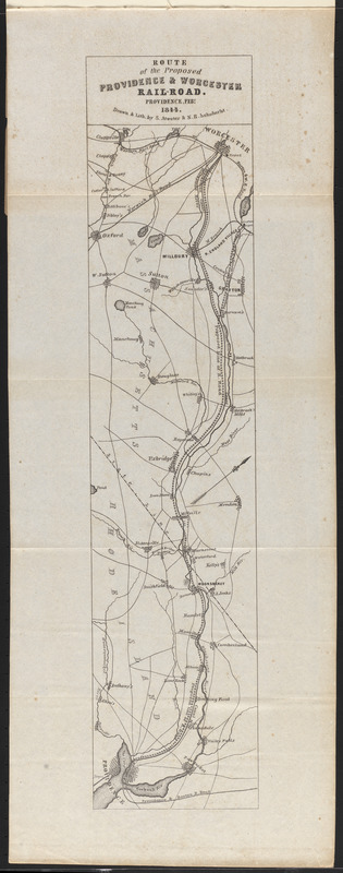
Route of the proposed Providence & Worcester rail-road
Route of the proposed Providence & Worcester rail-road
×
Item Information
Title:
Route of the proposed Providence & Worcester rail-road
Contributor:
Providence and Worcester Railroad Company
Contributor:
Rhode Island
Contributor:
Massachusetts
Cartographer:
Atwater, S.
Cartographer:
Schubarht, N.B.
Name on Item:
drawn & lith. by S. Atwater & N.B. Schubarht
Date:
1844
Format:
Maps/Atlases
Location:
Boston Public Library
Norman B. Leventhal Map Center
Collection (local):
Norman B. Leventhal Map Center Collection
Subjects:
Providence and Worcester Railroad Company--Maps
Railroads--Rhode Island--Maps
Railroads--Massachusetts--Maps
Rhode Island--Maps
Massachusetts--Maps
Providence and Worcester Railroad Company
Places:
Rhode Island
Massachusetts
Extent:
1 map ; 53 x 12 cm
Permalink:
https://ark.digitalcommonwealth.org/ark:/50959/0r96fq456
Terms of Use:
No known copyright restrictions.
No known restrictions on use.
Publisher:
[Providence?, R.I.] : [publisher not identified]
Scale:
Scale approximately 1:130,000
Language:
English
Notes:
Relief shown by hachures.
Oriented with north to the upper right.
Folded map in "Charters of the Providence and Worcester Rail Road Company."
Identifier:
06_01_016167
Call #:
HE2791 .P922 1844a
Barcode:
30000006378484
show more...
View MODS XML
More Like This
Route of the Providence and Worcester rail road
Map of Massachusetts, Connecticut and Rhode Island constructed ...
Map of Massachusetts, Connecticut and Rhode Island constructed ...
Map of Massachusetts, Rhode-Island & Connecticut : compiled from ...
Find More Like This >>
Tools
Share
Facebook
Pinterest
X
Reddit
Tumblr
Email
Copy link
Add to Folder
Questions/Comments
Cite This Item
IIIF Manifest
Downloads
Primary (full resolution, uncompressed)
(TIF, 80.3 MB)
Large (full resolution)
(JPEG, 6.75 MB)
Medium
(JPEG, 104 KB)