Skip to search
Skip to main content
Skip to first result
Digital Commonwealth
Folders
Sign Up / Log In
Search for
Search
Search
Search
Basic
Advanced
Explore
Map
Collections
Institutions
Formats
For Educators
Primary Source Sets
Lesson Plans
Using Primary Sources
Searching Digital Commonwealth
For Institutions
Join Digital Commonwealth
Conferences, Trainings, & Events
How to Contribute Collections
Digitization Services
Board & Committees
Frequently Asked Questions
About
About Digital Commonwealth
News & Announcements
Copyright & Terms of Use
Harmful Content Statement
Partners
API
Contact Us
Search
Search Constraints
Start Over
Save Search
Your search:
More Like
commonwealth:vh53xt23r
✖
Remove constraint More Like: commonwealth:vh53xt23r
« Prev.
|
701
-
800
of
817
|
Next »
Sort
by relevance
relevance
title
date (asc)
date (desc)
Number of results to display per page
100
per page
per page
10
per page
20
per page
50
per page
100
per page
View results as:
List
list view
Maps
map view
Gallery
grid view
Search Results
701.
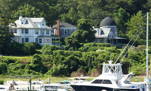
Whaling Church - Dr Fisher House
702.
Whiting Farm
703.
Wildlife - Deer - Buttonwood Farm Pond
704.
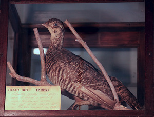
Wildlife - Heath Hen
705.
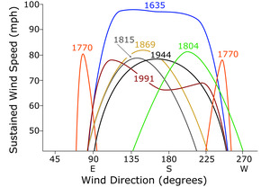
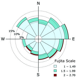
Wind Direction and Damage Level for Major Hurricanes
706.
Wind Direction and Damage Level for Major Hurricanes
707.
Wind Direction and Damage Level for Major Hurricanes
708.
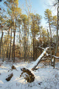
Wind thrown Pine
709.
Windmill House
710.
Windmill House
711.
Windmill House
712.
Winter Blizzard - Gut and North Neck
713.
Wompesket - Red Maple Swamp - Behind Suzy Trees
714.
Woodland History in the Modern Landscape
715.
Woods Hole - Ferry
716.
Woods Preserve
717.
Woods Preserve
718.
Woods Preserve - Barn
719.
Woods Preserve - Barn - Stone work
720.
Woods Preserve - Dead Oaks
721.
Woods Preserve - Dead Oaks
722.
Woods Preserve - Dead oaks
723.
Woods Preserve - From North Road - Moraine View from West
724.
Woods Preserve - house and stone work
725.
Woods Preserve - Mesic Forest
726.
Woods Preserve - Root Cellar
727.
Woods Preserve - Stone work
728.
Woods Reserve - Dead Oaks - Vineyard Conservation Society walk
729.
Woods Reserve - Dead Oaks and Sorrel on Ridge Top
730.
Woods Reserve - Mined Boulder 3
731.
Worth Whaling Agency Sign
732.
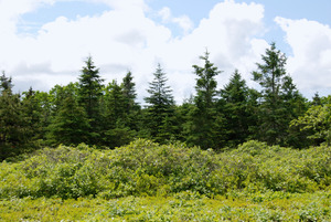
Young Spruce Plantation
733.
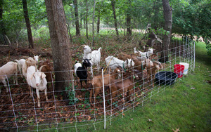
Your Backyard Farm - Becky Brown - Goats
734.
A New England Food Vision
735.
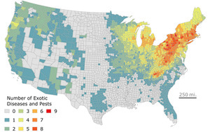
Northeast Forest Disease and Insects
736.
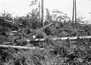
Pisgah Hurricane Damage 1942
737.
Wildlands and Woodlands - A Vision for the Forests of Massachusetts
738.
Wildlands and Woodlands - A Vision for the New England Landscape
739.
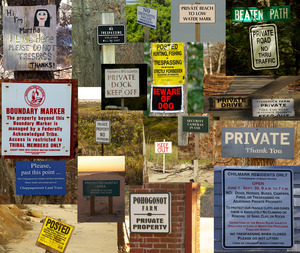
Access signs collage
740.
Allen Farm - sheep
741.
Church
742.
Mattakesset Lodge Katama
743.
Menemsha After 1938 Hurricane
744.
Menemsha Before 1938 Hurricane
745.
Bird's Eye View of Boston Harbor : in Colors, Along the South Shore to Plymouth, Cape Cod Canal and Provincetown Showing All...
746.
Boston Harbor
747.
Boston Harbor, Mass.: Sketch Showing Locations of Works For Its Improvement.
748.
Boston Harbor, Massachusetts
749.
Boston Harbor, Massachusetts: The Main Ship Channel Above Lower Middle
750.
Boston Harbour: From the Survey of A.S. Wadsworth Esq., U.S.N, and the Survey of Des Barres.
751.
Boston Harbour: From the Survey of A.S. Wadsworth Esq., U.S.N, and the Survey of Des Barres.
752.
Boston With its Environs, 1775 & 1776.
753.
Boston Y Sus Aldredores - Boston Et Ses Environs
754.
A Chart Exhibiting the Normal Course & Velocity of the Tidal Current at Ebb in Boston Harbor
755.
Chart of the Harbours of Salem, Marblehead, Beverly, and Manchester From a Survey Taken in the Years 1804, 5 & 6 by Nathl....
756.
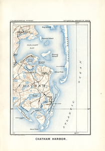
Chatham Harbor
757.
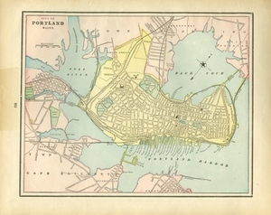
City of Portland Maine.
758.
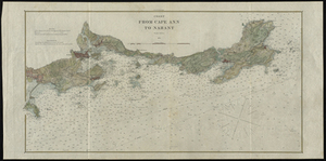
Coast from Cape Ann to Nahant
759.
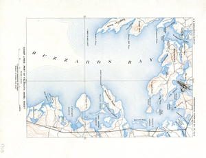
Coast Lines: Part of Falmouth (Mass.) Sheet
760.
Coast Lines: Part of Martha's Vineyard (Mass.) Sheet
761.
Coast Lines: Part of Provincetown and Wellfleet (Mass.) Sheets
762.
Comparative Sketch of the Handkerchief Shoal Entrance to Nantucket Sound, Mass. Showing its Increase
763.
Duxbury Harbor, Mass. Showing Proposed Improvements
764.
Entrance of Newburyport Harbor, Mass.: Plan Showing Condition of Improvement
765.
Essex County
766.
Geologic Map of Cape Ann, Mass.: Showing Distribution of Dikes, etc.
767.
Gloucester
768.
Gloucester
769.
Gloucester Harbor, Massachusetts
770.
Gloucester Harbor, Massachusetts
771.
Gloucester Harbor, Massachusetts: Inner Harbor
772.
Harbor of Refuge at Hyannis, Mass.
773.
Harbor of Refuge, Nantucket, Mass., Plat B Proposed Location of the Eastern Jetty in Case the Channel is to Be Excavated Partly...
774.
Harbor of Refuge, Sandy Bay, Cape Ann, Massachusetts: Scheme of Ranges for the Construction of the Submerged Enrockment of the...
775.
Harbor of Refuge, Woods Holl, Mass.
776.
Harbour of Annis Squam in Ipswich Bay.
777.
Historical Map of Nantucket
778.
Hyannis Harbor, Mass.: Surveyed in Accordance With an Act of Congress of July 5 1884, Under the Direction of George H. Elliot,...
779.
Lanesville, Bay View, Annisquam
780.
Manchester Harbor, Mass.Suveyed in Accordance with Act of Congress Approved August 5, 1886 Showing Proposed Improvements.
781.
Map of Entrance to Newburyport Harbor, Mass. Showing the Adopted Plan of Jetties
782.
Map of Sandy Bay, Rockport, Massachusetts Showing Proposed Breakwater for Harbor of Refuge.
783.
Map of Scituate Harbor: Showing the Plan Adopted For Making it a Harbor of Refuge
784.
Marblehead
785.
Martha's Vineyard Mass. Eastern End
786.
Nahant
787.
Nantucket Harbor, Mass., Plat C.
788.
New Bedford Harbor, Mass.
789.
New Bedford Harbor, Mass.
790.
New Driving Road Map of Essex County, Mass.
791.
Newbury
792.
Newburyport Harbor, Mass. Plan Showing Changes in Shore Lines at Entrance, the Location and Condition of the Jetties, and the...
793.
Newburyport Harbor, Mass.: Plan Showing Changes in Shore Lines at Entrance, the Location and Condition of the Jetties, and the...
794.
Newburyport Harbor, Mass. Plan Showing Condition of Improvement
795.
Part of Nantucket (Mass.)
796.
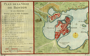
Plan De La Ville De Boston et ses environs
797.
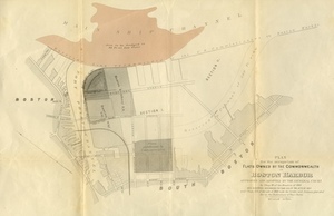
Plan for the Occupation of Flats Owned by the Commonwealth in Boston Harbor
798.
Plan For the Occupation of the South Boston Flats by the Commissioners on the Harbors and Flats of Massachusetts
799.
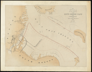
Plan of South Boston Flats Showing Location of Sea Walls and Area of Excavations and Filling
800.
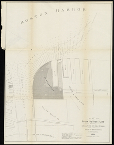
Plan of the First Section for the Occupation of the South Boston Flats by the Commissioners on the Harbors and Flats of...
« Previous
Next »
1
2
…
4
5
6
7
8
9
Limit your search
Subject
Coastal
812
Regional Studies
738
Agriculture
71
Massachusetts
70
Hurricanes
27
Conservation and Management
23
Historic and Retrospective Studies
21
Birds
20
more
Subject
»
Place
North and Central America
807
United States
807
Dukes (county)
698
Martha's Vineyard
604
Massachusetts
548
Chilmark
161
West Tisbury
123
Chappaquiddick Island
90
more
Place
»
Format
Photographs
621
Maps/Atlases
139
Objects/Artifacts
121
Postcards/Cards
1
Drawings/Illustrations
1
Available to use
Creative Commons license
743
Date
View distribution
Current results range from
1764
to
2016
Date range begin
Date range end
View larger »
Unknown
1
Collection
Harvard Forest Martha's Vineyard Collection
744
Historic Maps
73
Institution
Harvard University
738
Salem State University Archives and Special Collections
73
Martha's Vineyard Museum
4
The Vineyard Gazette
2