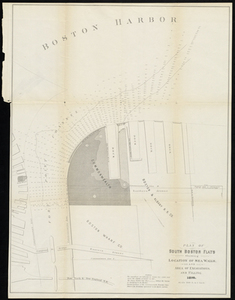
Skip to search
Skip to main content
Skip to first result
Digital Commonwealth
Folders
Sign Up / Log In
Search for
Search
Search
Search
Basic
Advanced
Explore
Map
Collections
Institutions
Formats
For Educators
Primary Source Sets
Lesson Plans
Using Primary Sources
Searching Digital Commonwealth
For Institutions
Join Digital Commonwealth
Conferences, Trainings, & Events
How to Contribute Collections
Digitization Services
Board & Committees
Frequently Asked Questions
About
About Digital Commonwealth
News & Announcements
Copyright & Terms of Use
Harmful Content Statement
Partners
API
Contact Us
Search
Search Constraints
Start Over
Save Search
Your search:
More Like
commonwealth:3f463274z
✖
Remove constraint More Like: commonwealth:3f463274z
« Prev. |
1
-
100
of
11,500
|
Next »
Sort
by relevance
relevance
title
date (asc)
date (desc)
Number of results to display per page
100
per page
per page
10
per page
20
per page
50
per page
100
per page
View results as:
List
list view
Maps
map view
Gallery
grid view
Search Results
1.
Plan of the harbour of Boston, from surveys made under the direction of commissioners appointed by a resolve of the...
2.
Port facilities at Boston, MA
3.
Map of Boston inner harbor
4.
Boston Bay and Harbor
5.
Boston Harbor
6.
Boston Harbor & vicinity
7.
Boston Harbor, Massachusetts
8.
Eldridge's new chart of Boston Harbor : compiled from the latest surveys
9.
Extract from the plan of the coast survey of Boston Harbor, 1847
10.
Map of Boston Harbor : showing commissioners' lines, wharves &c
11.
Map of Boston inner harbor to accompany report under chapter 93, resolves of 1907, December 1, 1907
12.
Map showing the terminal facilities of Boston
13.
Plan for the occupation of flats owned by the Commonwealth in Boston Harbor
14.
Plan of main ship channel in Boston Harbor showing the work of removing certain obstructions to navigation
15.
Plan showing encroachments upon the inner basins of Boston Harbor : accompanying annual report of Harbor and Land...
16.
Sketch of Boston Harbor and Bay
17.
Plan of South Boston Flats Showing Location of Sea Walls and Area of Excavations and Filling
18.
Plan For the Occupation of the South Boston Flats by the Commissioners on the Harbors and Flats of Massachusetts
19.
Map of Boston : showing freight and passenger depots, grain elevators, steamboat wharves, etc
20.
Map showing the terminal facilities of Boston
21.
Map showing the terminal facilities of Boston
22.
Plan of Boston proper : showing changes in street and wharf lines, 1795 to 1895
23.
Plan of City Wharf in Boston, Mass : shewing 14 lots of land on the side of the south dock of said wharf & Commercial St. : to...
24.
Plan of Hoosac Tunnel Dock and Elevator Company's docks and land in Charlestown, Mass.
25.
Plan for the occupation of flats owned by the Commonwealth in Boston Harbor
26.
Plan of Mystic River showing the Harbor Commissioners lines : Dec. 1854
27.
Plan of Neponset River and part of Dorchester Bay showing the harbor lines proposed by the Commissioners 1854
28.
Plan of the proposed docks at South Boston
29.
Boston Harbor Mass : Charles River from Brookline Street bridge to Market Street bridge
30.
Boston Harbor, Mass : map of Charles River from Brookline Street bridge to its mouth
31.
Boston Harbor, Massachusetts
32.
Boston Harbor, Massachusetts
33.
Boston Harbour : from the survey of A.S. Wadsworth Esq. U.S.N. and the chart of Des Barres
34.
Boston Inner Harbor Massachusetts
35.
Changes in the bed of Boston Harbor from a comparison of the surveys of 1835-61
36.
A chart exhibiting the normal course & velocity of the tidal current at ebb in Boston Harbor
37.
Chart of Boston Harbor : from the best authorities, 1873
38.
Chart of Boston Harbor and Massachusetts Bay : with map of the adjacent country
39.
Chart of Boston Harbour : surveyed in 1817
40.
Copy of a plan of South Bay
41.
Copy of part of plan of inner harbor of Boston, showing commissioners' lines
42.
Eldridge's new chart no. 4 Boston Harbor : compiled from the latest surveys
43.
J. Schedler's relief map of Boston and environs
44.
Map of Boston Harbor
45.
Map of Boston proper, Charlestown, South Boston and East Boston : showing original territory of old Boston, the areas filled...
46.
Map of the eastern junc. Broad Sound Pier, & Pt. Shirley railroad : steamboat lines and connections : established for the...
47.
Map showing the routes of The Winthrop Steamboat Co
48.
New chart of Boston Harbor
49.
Plan of Boston and its vicinity
50.
Plan of Boston and its vicinity
51.
[Plan of channels and flats as they were before the 200 feet outside of the Mill Dam was filled up]
52.
Plan of location of projected ship canal from Taunton River to Boston Harbor, through Weymouth Fore River ... Frank W. Hodgdon,...
53.
Plano de la bahia y puerto de Boston
54.
Sections of soundings made by order of the Harbor Committee of 1852
55.
Sketch of the narrows in Boston Harbor
56.
Atlas of Dorchester, West Roxbury and Brighton, city of Boston : plate 6
57.
Atlas of Dorchester, West Roxbury and Brighton, city of Boston : plate 5
58.
Atlas of Dorchester, West Roxbury and Brighton, city of Boston : plate 3
59.
Atlas of Dorchester, West Roxbury and Brighton, city of Boston : plate 1
60.
Atlas of Dorchester, West Roxbury and Brighton, city of Boston : plate 4
61.
Atlas of Dorchester, West Roxbury and Brighton, city of Boston : plate 2
62.
Atlas of Dorchester, West Roxbury and Brighton, city of Boston
63.
Atlas of Dorchester, West Roxbury and Brighton, city of Boston : plate 11
64.
Atlas of Dorchester, West Roxbury and Brighton, city of Boston : plate 10
65.
Atlas of Dorchester, West Roxbury and Brighton, city of Boston : plate 8
66.
Atlas of Dorchester, West Roxbury and Brighton, city of Boston : plate 18
67.
Atlas of Dorchester, West Roxbury and Brighton, city of Boston : plate 9
68.
Atlas of Dorchester, West Roxbury and Brighton, city of Boston : plate 7
69.
Atlas of Dorchester, West Roxbury and Brighton, city of Boston : index map
70.
Atlas of the city of Boston : Dorchester : from actual surveys and official plans
71.
Atlas of the city of Boston : Dorchester : from actual surveys and official plans
72.
Atlas of the city of Boston : Dorchester : from actual surveys and official plans
73.
Atlas of the city of Boston : Dorchester : volume three : from actual surveys and official records
74.
Atlas of the city of Boston : Dorchester : volume three : from actual surveys and official records : index map
75.
Atlas of the city of Boston : Dorchester : volume three : from actual surveys and official records : plate C
76.
Atlas of the city of Boston : Dorchester : volume three : from actual surveys and official records : plate A
77.
Atlas of the city of Boston : Dorchester : volume three : from actual surveys and official records : plate E
78.
Atlas of the city of Boston : Dorchester : volume three : from actual surveys and official records : plate D
79.
Atlas of the city of Boston : Dorchester : volume three : from actual surveys and official records : plate B
80.
Atlas of the city of Boston : Dorchester : volume three : from actual surveys and official records : plate I
81.
Atlas of the city of Boston : Dorchester : volume three : from actual surveys and official records : plate J
82.
Atlas of the city of Boston : Dorchester : volume three : from actual surveys and official records : plate K
83.
Atlas of the city of Boston : Dorchester : volume three : from actual surveys and official records : plate G
84.
Atlas of the city of Boston : Dorchester : volume three : from actual surveys and official records : plate H
85.
Atlas of the city of Boston : Dorchester : volume three : from actual surveys and official records : plate F
86.
Atlas of the city of Boston : Dorchester : volume three : from actual surveys and official records : plate L
87.
Atlas of the city of Boston : Dorchester : volume three : from actual surveys and official records : plate N
88.
Atlas of the city of Boston : Dorchester : volume three : from actual surveys and official records : plate R
89.
Atlas of the city of Boston : Dorchester : volume three : from actual surveys and official records : plate O
90.
Atlas of the city of Boston : Dorchester, Mass. : plate 2
91.
Atlas of the city of Boston : Dorchester, Mass. : plate 12
92.
Atlas of the city of Boston : Dorchester, Mass. : plate 8
93.
Atlas of the city of Boston : Dorchester, Mass. : plate 32
94.
Atlas of the city of Boston : Dorchester, Mass. : plate 25
95.
Atlas of the city of Boston : Dorchester, Mass. : plate 23
96.
Atlas of the city of Boston : Dorchester, Mass. : plate 26
97.
Atlas of the city of Boston : Dorchester, Mass. : plate 29
98.
Atlas of the city of Boston : Dorchester, Mass. : plate 18
99.
Atlas of the city of Boston : Dorchester, Mass. : plate 17
100.
Atlas of the city of Boston : Dorchester, Mass. : plate 22
« Previous
Next »
1
2
3
4
5
…
114
115
Limit your search
Subject
Real property--Massachusetts--Boston--Maps
2,286
Landowners--Massachusetts--Boston--Maps
2,125
Boston (Mass.)--Maps
1,982
Roxbury (Boston, Mass.)--Maps
352
Dorchester (Boston, Mass.)--Maps
331
Cambridge (Mass.)--Maps
266
Brookline (Mass.)--Maps
236
Real property--Massachusetts--Cambridge--Maps
216
more
Subject
»
Place
North and Central America
8,789
United States
7,713
Massachusetts
5,047
Suffolk (county)
3,448
Boston
3,308
Europe
1,359
Middlesex (county)
618
Canada
448
more
Place
»
Format
Maps/Atlases
11,441
Manuscripts
215
Prints
56
Books
35
Objects/Artifacts
10
Drawings/Illustrations
8
Posters
5
Available to use
No known restrictions
11,331
Creative Commons license
57
Date
View distribution
Current results range from
1482
to
2023
Date range begin
Date range end
View larger »
Unknown
2
Collection
Norman B. Leventhal Map & Education Center Collection
11,398
Boston and New England Maps (Collection of Distinction)
5,148
Urban Maps (Collection of Distinction)
4,872
Maritime Charts and Atlases (Collection of Distinction)
1,085
American Revolutionary War-Era Maps (Collection of Distinction)
616
Boston Redevelopment Authority Collection
99
Massachusetts Board of Harbor and Land Commissioners
66
Historic Maps
14
more
Collection
»
Institution
Boston Public Library
11,399
State Library of Massachusetts
75
Salem State University Archives and Special Collections
14
Private Collection
11
American Antiquarian Society
1