Skip to search
Skip to main content
Digital Commonwealth
Sign Up / Log In
Search for
Search
Search
Search
Basic
Advanced
Explore
Map
Collections
Institutions
Formats
For Educators
Primary Source Sets
Lesson Plans
Using Primary Sources
Searching Digital Commonwealth
For Institutions
Join Digital Commonwealth
Conferences, Trainings, & Events
How to Contribute Collections
Digitization Services
Board & Committees
Frequently Asked Questions
About
About Digital Commonwealth
News & Announcements
Copyright & Terms of Use
Harmful Content Statement
Partners
API
Contact Us
Boston Public Library
Norman B. Leventhal Map Center Collection
/
Boston and New England Maps (Collection of Distinction)
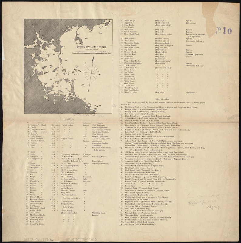
Boston Bay and Harbor
Boston Bay and Harbor
×
Item Information
Title:
Boston Bay and Harbor
Creator:
Boston (Mass.). Parks and Recreation Dept
Date:
[1888]
Format:
Maps/Atlases
Location:
Boston Public Library
Norman B. Leventhal Map Center
Collection (local):
Norman B. Leventhal Map Center Collection
Subjects:
Harbors--Massachusetts--Boston--Maps
Boston Harbor (Mass.)--Maps
Places:
Boston Harbor
Extent:
1 map ; 17 x 16 cm., on sheet 44 x 43 cm.
Permalink:
https://ark.digitalcommonwealth.org/ark:/50959/js956k91r
Terms of Use:
No known copyright restrictions.
No known restrictions on use.
Publisher:
Boston : Parks and Recreation Dept.
Scale:
Scale [ca. 1:36,200].
Language:
English
Notes:
Oriented with north toward the upper right.
Depths shown by soundings.
Includes index.
Notes (date):
This date is inferred.
Identifier:
06_01_005093
Call #:
G3762.B6 1888 .B6
Barcode:
39999059009462
show more...
View MODS XML
More Like This
Boston Harbor
Boston Harbor & vicinity
Boston Harbor, Massachusetts
Eldridge's new chart of Boston Harbor : compiled from the latest ...
Find More Like This >>
Tools
Share
Facebook
Pinterest
X
Reddit
Tumblr
Email
Copy link
Add to Folder
Questions/Comments
Cite This Item
IIIF Manifest
Downloads
Primary (full resolution, uncompressed)
(TIF, 48.5 MB)
Large (full resolution)
(JPEG, 4.08 MB)
Medium
(JPEG, 197 KB)