Skip to search
Skip to main content
Digital Commonwealth
Sign Up / Log In
Search for
Search
Search
Search
Basic
Advanced
Explore
Map
Collections
Institutions
Formats
For Educators
Primary Source Sets
Lesson Plans
Using Primary Sources
Searching Digital Commonwealth
For Institutions
Join Digital Commonwealth
Conferences, Trainings, & Events
How to Contribute Collections
Digitization Services
Board & Committees
Frequently Asked Questions
About
About Digital Commonwealth
News & Announcements
Copyright & Terms of Use
Harmful Content Statement
Partners
API
Contact Us
Boston Public Library
Boston Redevelopment Authority Collection
/
Urban Maps (Collection of Distinction)
/
Boston and New England Maps (Collection of Distinction)
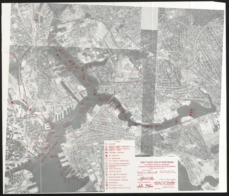
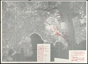
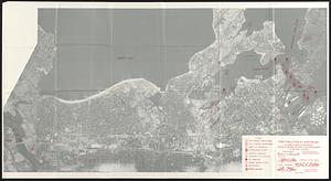
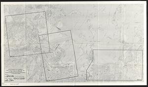
Port facilities at Boston, MA
Viewing image 1 of 4
Next >
Port facilities at Boston, MA
×
Next
Item Information
Title:
Port facilities at Boston, MA
Cartographer:
United States. Board of Engineers for Rivers and Harbors
Name on Item:
data by M.J. Shama ; drawn by C.B. Foster ; U.S. Army Corps of Engineers, Board of Engineers for Rivers and Harbors
Date:
1976
Format:
Maps/Atlases
Location:
Boston Public Library
Central Library in Copley Square
Collection (local):
Boston Public Library Collection
Subjects:
Boston Harbor (Mass.)--Maps
Boston (Mass.)--Maps
Boston (Mass.)--Remote-sensing images
Harbors--Massachusetts--Boston--Maps
Wharves--Massachusetts--Boston--Maps
Commercial buildings--Massachusetts--Boston--Maps
Industrial buildings--Massachusetts--Boston--Maps
Storage facilities--Massachusetts--Boston--Maps
Places:
Suffolk (county)
>
Boston
Extent:
4 maps ; 65 x 96 cm or smaller
Permalink:
https://ark.digitalcommonwealth.org/ark:/50959/x633hh496
Terms of Use:
No known copyright restrictions.
No known restrictions on use.
Publisher:
Ft. Belvoir, VA : Board of Engineers for Rivers and Harbors
Language:
English
Table of Contents:
Map no. 1
Map no. 2
Map no. 3
Location map with channels port facilities at Boston, MA
Notes:
Aerial images of the port with red overprint indicating facilities.
"Field data June 1978. Aerial flown July 1978."
Identifier:
06_01_017331b
06_01_017331c
06_01_017331a
06_01_017331d
Call #:
BRA/2822
Barcode:
30000007577232
show more...
View MODS XML
More Like This
Plan of the harbour of Boston, from surveys made under the ...
Plan of South Bay showing the Harbor Commissioners lines
Boston Harbor & vicinity
Map showing the terminal facilities of Boston
Find More Like This >>
Tools
Share
Facebook
Pinterest
X
Reddit
Tumblr
Email
Copy link
Add to Folder
Questions/Comments
Cite This Item
IIIF Manifest
Downloads
Primary (full resolution, uncompressed)
(TIF, multi-file ZIP, 316 MB)
Large (full resolution)
(JPEG, multi-file ZIP, 2.8 MB)
Medium
(JPEG, multi-file ZIP, 363 KB)