Skip to search
Skip to main content
Digital Commonwealth
Sign Up / Log In
Search for
Search
Search
Search
Basic
Advanced
Explore
Map
Collections
Institutions
Formats
For Educators
Primary Source Sets
Lesson Plans
Using Primary Sources
Searching Digital Commonwealth
For Institutions
Join Digital Commonwealth
Conferences, Trainings, & Events
How to Contribute Collections
Digitization Services
Board & Committees
Frequently Asked Questions
About
About Digital Commonwealth
News & Announcements
Copyright & Terms of Use
Harmful Content Statement
Partners
API
Contact Us
Boston Public Library
Norman B. Leventhal Map Center Collection
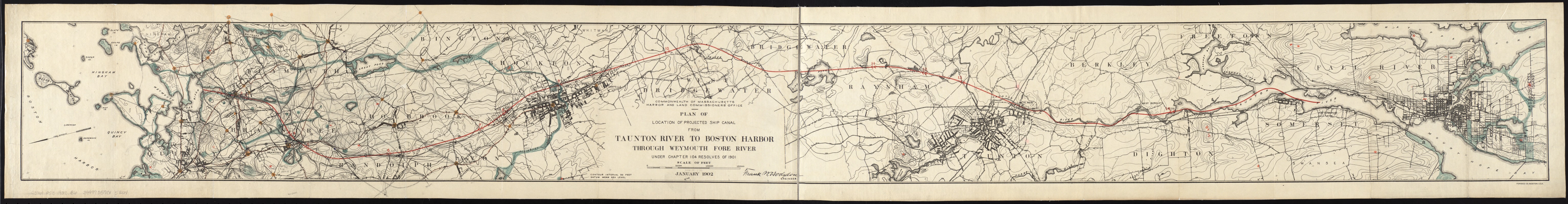
Plan of location of projected ship canal from Taunton River to Boston Harbor, through Weymouth Fore River ... Frank W. Hodgdon, engineer
Plan of location of projected ship canal from Taunton River to Boston Harbor, through Weymouth Fore River ... Frank W. Hodgdon, engineer
×
Item Information
Title:
Plan of location of projected ship canal from Taunton River to Boston Harbor, through Weymouth Fore River ... Frank W. Hodgdon, engineer
Creator:
Board of Harbor and Land Commissioners of Massachusetts
Name on Item:
Commonwealth of Massachusetts, Harbor and Land Commissioners' Office.
Date:
1902
Format:
Maps/Atlases
Location:
Boston Public Library
Norman B. Leventhal Map Center
Collection (local):
Norman B. Leventhal Map Center Collection
Subjects:
Canals--Massachusetts--Design and construction--Maps
Taunton River (Mass.)--Maps
Boston Harbor (Mass.)--Maps
Weymouth Fore River (Mass.)--Maps
Massachusetts--Maps
Places:
Boston Harbor
Taunton
(river)
Norfolk (county)
>
Weymouth Fore River
(bay)
Extent:
1 map ; 18 x 174 cm.
Permalink:
https://ark.digitalcommonwealth.org/ark:/50959/js956k17g
Terms of Use:
No known copyright restrictions.
No known restrictions on use.
Publisher:
Boston : [The Commissioners]
Scale:
Scale [ca. 1:36,000].
Language:
English
Notes:
Relief shown by contours.
Oriented with north toward the lower left.
"January 1902."
From the Board's Annual report for 1901.
"Under Chapter 104, Resolves of 1901."
Identifier:
06_01_005581
Call #:
G3761.P53 1902 .B6
Barcode:
39999059015261
show more...
View MODS XML
More Like This
Chart of Boston Harbor and Massachusetts Bay : with map of the ...
J. Schedler's relief map of Boston and environs
Map of Boston Harbor
Map showing the terminal facilities of Boston
Find More Like This >>
Tools
Share
Facebook
Pinterest
X
Reddit
Tumblr
Email
Copy link
Add to Folder
Questions/Comments
Cite This Item
IIIF Manifest
Downloads
Primary (full resolution, uncompressed)
(TIF, 86.7 MB)
Large (full resolution)
(JPEG, 7.28 MB)
Medium
(JPEG, 1.7 MB)