11161. Washington Street boulevard study : generalized land use - proposed Creator: Boston Redevelopment Authority; Stull and Lee, Inc. Format: Maps/Atlases Collection: Boston Redevelopment Authority Collection / Boston and New England Maps (Collection of Distinction) / Norman B. Leventhal Map Center Collection / Urban Maps (Collection of Distinction) Date: [ca. 1990] Institution: Boston Public Library
11162. Washington Street boulevard study : proposed fabric Creator: Boston Redevelopment Authority; Stull and Lee, Inc. Format: Maps/Atlases Collection: Boston Redevelopment Authority Collection / Boston and New England Maps (Collection of Distinction) / Norman B. Leventhal Map Center Collection / Urban Maps (Collection of Distinction) Date: [ca. 1990] Institution: Boston Public Library
11163. Washington Street boulevard study : corridor wide urban design strategy Creator: Boston Redevelopment Authority; Stull and Lee, Inc. Format: Maps/Atlases Collection: Boston Redevelopment Authority Collection / Boston and New England Maps (Collection of Distinction) / Norman B. Leventhal Map Center Collection / Urban Maps (Collection of Distinction) Date: [ca. 1990] Institution: Boston Public Library
11164. Planting beds on Dartmouth Street and Boylston Street in Copley Square Format: Maps/Atlases Collection: Boston Redevelopment Authority Collection / Boston and New England Maps (Collection of Distinction) / Norman B. Leventhal Map Center Collection / Urban Maps (Collection of Distinction) Date: July 28, 1990 Institution: Boston Public Library
11165. Flirtation walk schematic planting plan Charlestown Navy Yard Creator: Boston Redevelopment Authority Format: Maps/Atlases Collection: Boston Redevelopment Authority Collection / Boston and New England Maps (Collection of Distinction) / Norman B. Leventhal Map Center Collection / Urban Maps (Collection of Distinction) Date: July 30, 1990 Institution: Boston Public Library
11166. Waterfront skyline Format: Maps/Atlases Collection: Boston Redevelopment Authority Collection / Boston and New England Maps (Collection of Distinction) / Norman B. Leventhal Map Center Collection / Urban Maps (Collection of Distinction) Date: [ca. 1991] Institution: Boston Public Library
11167. Berkeley Street community garden Creator: Boston Redevelopment Authority Format: Maps/Atlases Collection: Boston Redevelopment Authority Collection / Boston and New England Maps (Collection of Distinction) / Norman B. Leventhal Map Center Collection / Urban Maps (Collection of Distinction) Date: September 1991 Institution: Boston Public Library
11168. Asia Creator: United States. Central Intelligence Agency Format: Maps/Atlases Collection: Norman B. Leventhal Map Center Collection Date: [1992] Institution: Boston Public Library
11169. Infrastructure around Tobin Bridge/US route 1 in Charlestown Creator: Boston Redevelopment Authority Format: Maps/Atlases Collection: Boston Redevelopment Authority Collection / Boston and New England Maps (Collection of Distinction) / Norman B. Leventhal Map Center Collection / Urban Maps (Collection of Distinction) Date: [1992] Institution: Boston Public Library
11170. Circulation plan of parking lot at the corner of VFW Parkway and Spring Street, West Roxbury Creator: Liston Associates Format: Maps/Atlases Collection: Boston Redevelopment Authority Collection / Boston and New England Maps (Collection of Distinction) / Norman B. Leventhal Map Center Collection / Urban Maps (Collection of Distinction) Date: July 1992 Institution: Boston Public Library
11171. East Asia Creator: United States. Central Intelligence Agency Format: Maps/Atlases Collection: Norman B. Leventhal Map Center Collection Date: [1993] Institution: Boston Public Library
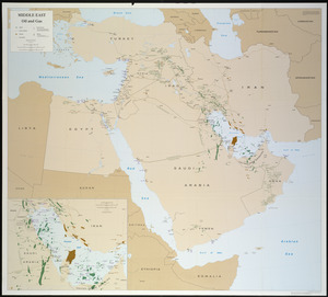
11172. Middle East, oil and gas : Middle East Creator: United States. Central Intelligence Agency Format: Maps/Atlases Collection: Norman B. Leventhal Map Center Collection Date: [1993] Institution: Boston Public Library
11173. North Atlantic Ocean, West Indies Creator: Netherlands. Koninklijke Marine. Dienst der Hydrografie; United States. Defense Mapping Agency Hydrographic/Topographic Center Format: Maps/Atlases Collection: Norman B. Leventhal Map Center Collection Date: 1993 Institution: Boston Public Library
11174. Haiti Creator: United States. Central Intelligence Agency Format: Maps/Atlases Collection: Norman B. Leventhal Map Center Collection Date: 1994 Institution: Boston Public Library
11175. Major thoroughfare system, city of Boston, July, 1994 Creator: Boston Redevelopment Authority Format: Maps/Atlases Collection: Boston and New England Maps (Collection of Distinction) / Norman B. Leventhal Map Center Collection / Urban Maps (Collection of Distinction) Date: [1994] Institution: Boston Public Library
11176. North Atlantic Ocean, southeast coast of North America, including the Bahamas and Greater Antilles Creator: United States. Defense Mapping Agency Hydrographic/Topographic Center Format: Maps/Atlases Collection: Norman B. Leventhal Map Center Collection Date: 1994 Institution: Boston Public Library
11177. Mediterranean Sea, plans on the coasts of Italy and Sicilia Creator: United States. Defense Mapping Agency Format: Maps/Atlases Collection: Norman B. Leventhal Map Center Collection Date: [1996] Institution: Boston Public Library
11178. Tactical pilotage chart, TPC Creator: United States. National Imagery and Mapping Agency Format: Maps/Atlases Collection: Norman B. Leventhal Map Center Collection Date: [1997] Institution: Boston Public Library
11179. Boston shoreline 1630 Creator: Map Works, Inc. Format: Maps/Atlases Collection: Boston and New England Maps (Collection of Distinction) / Norman B. Leventhal Map Center Collection / Urban Maps (Collection of Distinction) Date: 1999 Institution: Boston Public Library
11180. Boston shoreline 1795 Creator: Map Works, Inc. Format: Maps/Atlases Collection: Boston and New England Maps (Collection of Distinction) / Norman B. Leventhal Map Center Collection / Urban Maps (Collection of Distinction) Date: 1999 Institution: Boston Public Library