Skip to search
Skip to main content
Digital Commonwealth
Sign Up / Log In
Search for
Search
Search
Search
Basic
Advanced
Explore
Map
Collections
Institutions
Formats
For Educators
Primary Source Sets
Lesson Plans
Using Primary Sources
Searching Digital Commonwealth
For Institutions
Join Digital Commonwealth
Conferences, Trainings, & Events
How to Contribute Collections
Digitization Services
Board & Committees
Frequently Asked Questions
About
About Digital Commonwealth
News & Announcements
Copyright & Terms of Use
Harmful Content Statement
Partners
API
Contact Us
Boston Public Library
Norman B. Leventhal Map Center Collection
/
Boston Redevelopment Authority Collection
/
Urban Maps (Collection of Distinction)
/
Boston and New England Maps (Collection of Distinction)
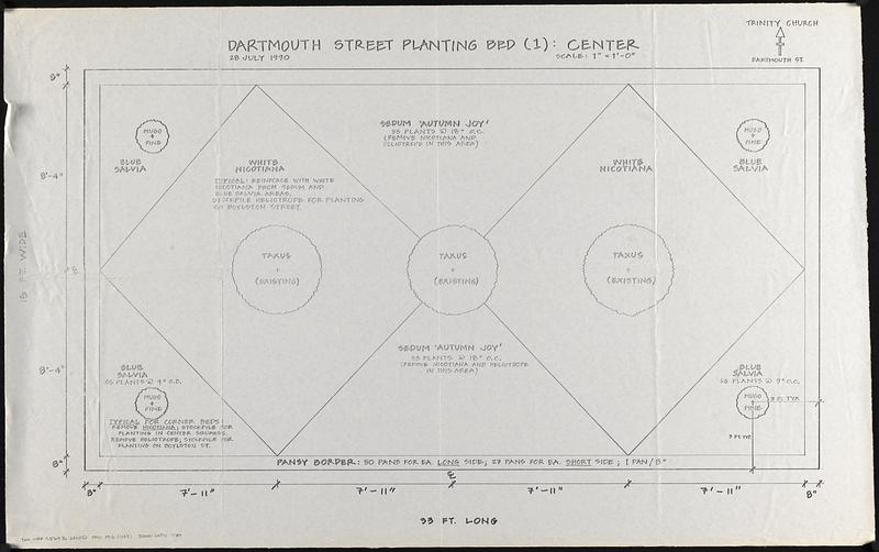
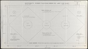
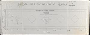
Planting beds on Dartmouth Street and Boylston Street in Copley Square
Viewing image 1 of 3
Next >
Planting beds on Dartmouth Street and Boylston Street in Copley Square
×
Next
Item Information
Title:
Planting beds on Dartmouth Street and Boylston Street in Copley Square
Date:
July 28, 1990
Format:
Maps/Atlases
Location:
Boston Public Library
Norman B. Leventhal Map Center
Collection (local):
Norman B. Leventhal Map Center Collection
Series:
Boston Redevelopment Authority Maps & Manuscript Plans Collection
Subjects:
Beds (Gardens)--Massachusetts--Boston--Maps
City planning--Massachusetts--Boston--Maps
Back Bay (Boston, Mass.)--Planting--Maps
Copley Square (Boston, Mass.)--Planting--Maps
Places:
Suffolk (county)
>
Boston
>
Back Bay
Copley Square
Extent:
3 maps ; sheets 61 x 119 cm or smaller
Permalink:
https://ark.digitalcommonwealth.org/ark:/50959/j9604j38q
Terms of Use:
No known copyright restrictions.
No known restrictions on use.
Place of origin:
[Boston]
Scale:
Scale 1:12. 1" = 1'-0"
Language:
English
Table of Contents:
Dartmouth Street planting bed (1): center
Dartmouth Street planting beds (2): left and right
Boylston St. planting beds (2): at grade
Notes:
Photocopies of manuscript maps showing dimensions, layout and types of plants.
Includes notes about changes and planting details.
"28 July 1990."
Identifier:
06_01_017844A
06_01_017844B
06_01_017844C
Call #:
BRA MAP FOLDER 2
Barcode:
30000007747789
show more...
View MODS XML
More Like This
660 Wakulah St., Roxbury
Allston-Brighton open space plan site inventory
Appleton St. Woonerf
Back Bay Fens master plan
Find More Like This >>
Tools
Share
Facebook
Pinterest
X
Reddit
Tumblr
Email
Copy link
Add to Folder
Questions/Comments
Cite This Item
IIIF Manifest
Downloads
Primary (full resolution, uncompressed)
(TIF, multi-file ZIP, 351 MB)
Large (full resolution)
(JPEG, multi-file ZIP, 3.11 MB)
Medium
(JPEG, multi-file ZIP, 158 KB)