Skip to search
Skip to main content
Skip to first result
Digital Commonwealth
Folders
Sign Up / Log In
Search for
Search
Search
Search
Basic
Advanced
Explore
Map
Collections
Institutions
Formats
For Educators
Primary Source Sets
Lesson Plans
Using Primary Sources
Searching Digital Commonwealth
For Institutions
Join Digital Commonwealth
Conferences, Trainings, & Events
How to Contribute Collections
Digitization Services
Board & Committees
Frequently Asked Questions
About
About Digital Commonwealth
News & Announcements
Copyright & Terms of Use
Harmful Content Statement
Partners
API
Contact Us
Search
Search Constraints
Start Over
Save Search
Your search:
More Like
commonwealth:k356cp79b
✖
Remove constraint More Like: commonwealth:k356cp79b
« Prev. |
1
-
100
of
64,093
|
Next »
Sort
by date (desc)
relevance
title
date (asc)
date (desc)
Number of results to display per page
100
per page
per page
10
per page
20
per page
50
per page
100
per page
View results as:
List
list view
Maps
map view
Gallery
grid view
Search Results
1.
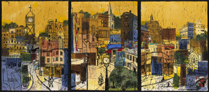
Library of Babel
2.
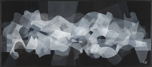
Neighborhood Kaleidoscope
3.
Realtà Senza Titolo 10 (Untitled Reality 10)
4.
Commonwealth of Massachusetts U.S. congressional districts
5.
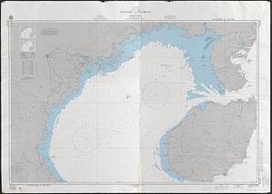
South China Sea, Gulf of Tonkin, Vietnam--China, C'ua Nhuong to Leizhou Bandao including Hainan Dao
6.
Asia, South China Sea, Mui Da Nang to Shenquan Gang including Hainan Dao and Parcel Islands
7.
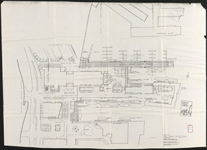
Longwood Medical Area
8.
Illustrative site plan : a proposal for community review South End/Lower Roxbury development policy
9.
Illustrative site plan : a proposal for community review South End/Lower Roxbury development policy
10.
FPIR/FEIR Olmsted Plaza : a redevelopment of the Sears property, 309 Park Drive/201 Brookline Avenue in the Fenway
11.
Ruggles Center : existing condition plan
12.
Ruggles Center : site area diagram
13.
Hancock Woods : as of right plan
14.
Architectural styles, Chinatown historic core, historic edge
15.
Mass pike air rights study
16.
Cultural facilities conceptual plan
17.
Midtown area plan for the public realm
18.
South End urban renewal area project Mass. r-56 site preparation contract no. 50 Worcester Square Park reconstruction
19.
Shawmut Avenue
20.
Hancock Woods EGA
21.
Conceptual plan
22.
Downtown and neighborhood cultural facilities
23.
Midtown improvement area
24.
Copley Square : layout and pavement plan with tree numbers added
25.
Conceptual plan
26.
Downtown Boston
27.
Herald Street improvements
28.
Open space management program index map
29.
Boston University, Charles River campus master plan
30.
Plan for Boston
31.
Long Wharf phase II illustrative plan
32.
Long Wharf DEM/BRA master plan : master plan scheme
33.
Long Wharf DEM/BRA master plan : proposed dredging scheme
34.
DEM/BRA Long Wharf master plan : schematic'
35.
Wastewater system map, Boston proper, sheet no. 21h
36.
Water distribution system map, Boston proper, sheet no. 21h
37.
Water distribution system map, Boston proper, sheet no. 22h
38.
Water system map, Boston proper, sheet no. 22h
39.
Neighborhood boundaries 1980
40.
Marketplace Center : topographical survey plan
41.
St. James Avenue garage parcel
42.
Boston city map & guide to the Freedom Trail & national historical park
43.
Off-street parking inventory within Boston proper
44.
Parcel D-10
45.
Aerial photo of Charlestown, Massachusetts
46.
A land ownership map for the Longwood Medical Area as of January 1980
47.
Metropolitan District Commission combined sewer overflow project Dorchester Bay area
48.
Topographic map of Boston, Mass.
49.
Waterfront project, Pierhead Line, Boston, Mass.
50.
Boston Harbor : challenges and opportunities for the 1980's
51.
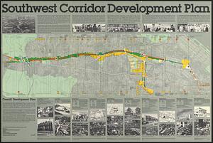
Southwest corridor development plan
52.
Park Plaza urban renewal area : map no. 6 land disposal map
53.
Park Plaza traffic improvements & grade level controls
54.
Roxbury
55.
Park Plaza urban renewal area : map no. 3 land acquisition map
56.
Adams Nervine Asylum
57.
Park Plaza : illustrative site plan
58.
Park Plaza : illustrative site plan showing alternate apartment building configuration
59.
Boston urban wilds
60.
Port facilities at Boston, MA
61.
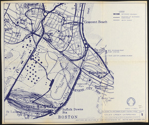
Revere, Sales Creek - flood control study
62.
Contract documents for the Waterfront Park, Boston, Massachusetts : planting plan
63.
Boston proper
64.
Illustrative re-use site plan for the regional core
65.
Park Plaza building study stage environmental impact analysis : environmental base : sanitary sewerage and storm drainage
66.
Wards & precincts
67.
Boston public schools and police reporting areas
68.
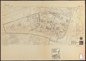
South Cove urban renewal area R-92 : disposition plan
69.
Downtown waterfront-Faneuil Hall project urban renewal area Massachusetts R-77 : illustrative site plan
70.
Downtown waterfront-Faneuil Hall project urban renewal area Massachusetts R-77 : illustrative site plan
71.
Downtown waterfront-Faneuil Hall urban renewal area Massachusetts R-77 : proposed land use
72.
Park Plaza urban renewal area : environmental deficiencies and blighting influences map
73.
Park Plaza urban renewal area : environmental deficiencies and blighting influences map
74.
Park Plaza urban renewal area : building conditions map
75.
Fenway urban renewal area Massachusetts : disposition parcels
76.
Park Plaza urban renewal area : 1973 survey building deficiencies map for Park Plaza stage I
77.
McConnell Park
78.
Campus High School urban renewal area Mass. r-129 : proposed land-use
79.
Campus High School urban renewal area Mass. r-129 : property map
80.
Campus High School urban renewal area Mass. r-129 : disposition parcels
81.
Campus High School urban renewal area Mass. r-129 : existing and proposed zoning
82.
Downtown waterfront-Faneuil Hall project urban renewal area Massachusetts R-77 : existing and proposed zoning
83.
Downtown waterfront-Faneuil Hall urban area Massachusetts R-77 : existing and proposed zoning
84.
Relationship between selected recreation sites and public transportation facilities Boston metropolitan area 1971
85.
McConnell Park Dorchester : site plan
86.
Park Plaza urban renewal area : map no. 4 building deficiencies map
87.
Park Plaza urban renewal area : map no. 5 ownership data map
88.
Park Plaza urban renewal area : map no. 2 land use map (existing)
89.
Park Plaza urban renewal area : map no. 1 boundary map
90.
Campus High School urban renewal area Massachusetts R-129 : illustrative site plan
91.
Developer's kit : South Cove urban renewal area, project no. Mass. r-92, parcel r-7, residential use
92.
Index to planning districts
93.
Public open space city of Boston
94.
Campus High School urban renewal area Mass. r-129 : existing land-use
95.
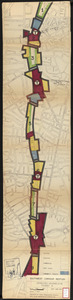
Southwest corridor restudy
96.
Illustrative site plan : South End urban renewal area, Massachusetts r-56
97.
South End urban renewal area R-56 : proposed rights-of-way
98.
Waterfront land inventory South Boston : CRP port study
99.
Mother Brook recreation study
100.
Central business district urban renewal area Massachusetts r-82 A,B,C : disposition parcels
« Previous
Next »
1
2
3
4
5
…
640
641
Limit your search
Subject
City planning--Massachusetts--Boston--Maps
352
Urban renewal--Massachusetts--Boston--Maps
232
Boston (Mass.)--Maps
106
Birney, James Gillespie, 1792-1857
105
Land use--Massachusetts--Boston--Maps
96
Buildings--Massachusetts--Boston--Maps
73
Italian Americans
56
Italians
56
more
Subject
»
Place
North and Central America
62,573
United States
62,567
Massachusetts
62,028
Suffolk (county)
44,662
Boston
44,661
Worcester (county)
12,913
Worcester
12,825
Dorchester
6,452
more
Place
»
Format
Newspapers
63,423
Maps/Atlases
400
Books
111
Objects/Artifacts
86
Letters/Correspondence
55
Manuscripts
55
Paintings
17
Prints
2
Available to use
No known restrictions
64,088
Date
View distribution
Current results range from
1770
to
2017
Date range begin
Date range end
View larger »
Unknown
10
Collection
Newspapers from the Boston Public Library
63,423
Boston Evening Transcript
12,210
Worcester Daily Spy
7,740
Daily Evening Transcript
7,037
Springfield Weekly Republican
4,712
Roxbury Gazette and South End Advertiser
3,447
South Boston Gazette
2,944
The Dorchester Beacon
2,865
more
Collection
»
Institution
Boston Public Library
64,092
Massachusetts Historical Society
1