Skip to search
Skip to main content
Digital Commonwealth
Sign Up / Log In
Search for
Search
Search
Search
Basic
Advanced
Explore
Map
Collections
Institutions
Formats
For Educators
Primary Source Sets
Lesson Plans
Using Primary Sources
Searching Digital Commonwealth
For Institutions
Join Digital Commonwealth
Conferences, Trainings, & Events
How to Contribute Collections
Digitization Services
Board & Committees
Frequently Asked Questions
About
About Digital Commonwealth
News & Announcements
Copyright & Terms of Use
Harmful Content Statement
Partners
API
Contact Us
Boston Public Library
Boston Redevelopment Authority Collection
/
Urban Maps (Collection of Distinction)
/
Boston and New England Maps (Collection of Distinction)
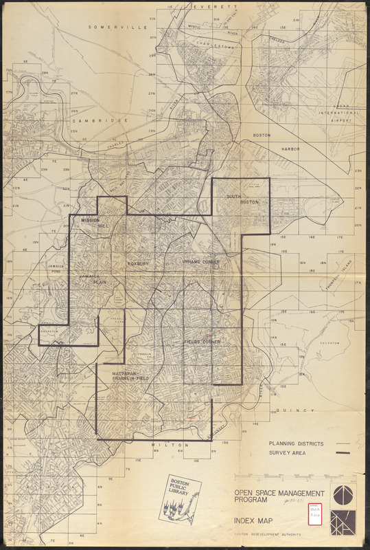
Open space management program index map
Open space management program index map
×
Item Information
Title:
Open space management program index map
Description:
Shows boundaries of the area surveyed in Boston for open space planning purposes. Includes parts of Mission Hill, Roxbury, Jamaica Plain, Uphams Corner, South Boston, Fields Corner and Mattapan/Franklin Field.
Cartographer:
Boston Redevelopment Authority
Date:
[ca. 1987]
Format:
Maps/Atlases
Location:
Boston Public Library
Central Library in Copley Square
Collection (local):
Boston Public Library Collection
Subjects:
Open spaces--Massachusetts--Boston--Maps
Boston (Mass.)--Maps
City planning--Massachusetts--Boston--Maps
Places:
Suffolk (county)
>
Boston
Extent:
1 map : hand colored ; 92 x 61 cm
Permalink:
https://ark.digitalcommonwealth.org/ark:/50959/7h14cx436
Terms of Use:
No known copyright restrictions.
No known restrictions on use.
Publisher:
[Boston] : [Boston Redevelopment Authority]
Scale:
Scale approximately 1:19,800
Language:
English
Referenced by:
http://bpl.bibliocommons.com/item/show/1034753075
Identifier:
06_01_017253x
Call #:
BRA/3212
Barcode:
39999065833822
show more...
View MODS XML
More Like This
Fenway urban renewal area, Massachusetts R-115 : illustrative site ...
Campus High School urban renewal area Massachusetts R-129 : ...
Charlestown urban renewal area, Massachusetts R-55 : illustrative ...
Illustrative site plan : a proposal for community review South ...
Find More Like This >>
Tools
Share
Facebook
Pinterest
X
Reddit
Tumblr
Email
Copy link
Add to Folder
Questions/Comments
Cite This Item
IIIF Manifest
Downloads
Primary (full resolution, uncompressed)
(TIF, 175 MB)
Large (full resolution)
(JPEG, 14.7 MB)
Medium
(JPEG, 210 KB)