Skip to search
Skip to main content
Digital Commonwealth
Sign Up / Log In
Search for
Search
Search
Search
Basic
Advanced
Explore
Map
Collections
Institutions
Formats
For Educators
Primary Source Sets
Lesson Plans
Using Primary Sources
Searching Digital Commonwealth
For Institutions
Join Digital Commonwealth
Conferences, Trainings, & Events
How to Contribute Collections
Digitization Services
Board & Committees
Frequently Asked Questions
About
About Digital Commonwealth
News & Announcements
Copyright & Terms of Use
Harmful Content Statement
Partners
API
Contact Us
Boston Public Library
Norman B. Leventhal Map & Education Center Collection
/
Maritime Charts and Atlases (Collection of Distinction)
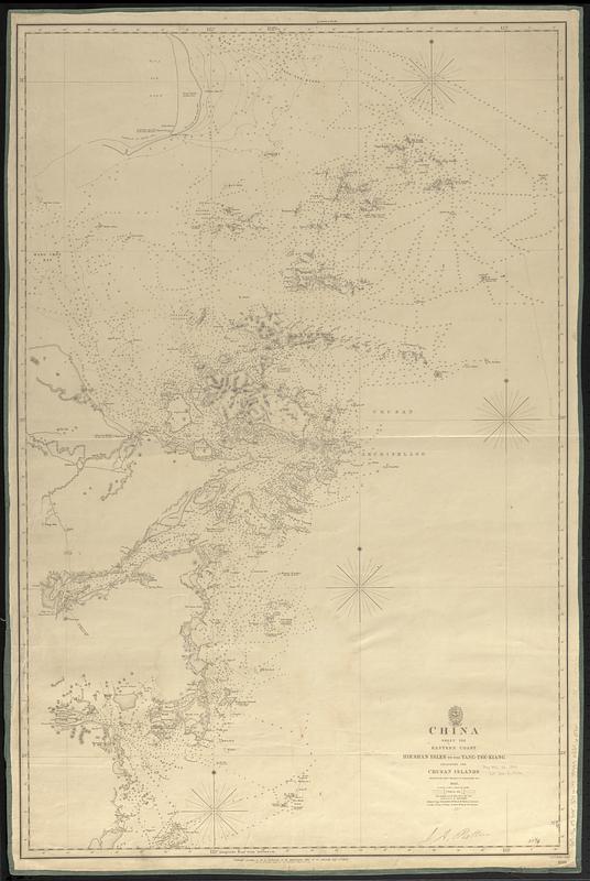
China : sheet VIII eastern coast Hieshan Isles to the Yang-Tse-Kiang including the Chusan Islands
China
×
Item Information
Title:
China : sheet VIII eastern coast Hieshan Isles to the Yang-Tse-Kiang including the Chusan Islands
Issuing body:
Great Britain. Hydrographic Department
Surveyor:
Collinson, Richard, Sir, 1811-1883
Surveyor:
Kellett, Henry, 1806-1875
Engraver:
J. & C. Walker (Firm)
Name on Item:
surveyed by Captns. Kellett & Collinson R.N., 1843 ; J. & C. Walker sculpt.
Date:
1849
Format:
Maps/Atlases
Genre:
Nautical charts
Location:
Boston Public Library
Norman B. Leventhal Map & Education Center
Collection (local):
Norman B. Leventhal Map & Education Center Collection
Subjects:
China--Maps
Coasts--China--Maps
Nautical charts--China
Places:
China
Extent:
1 map ; 93 x 61 cm
Permalink:
https://ark.digitalcommonwealth.org/ark:/50959/02875673j
Terms of Use:
No known copyright restrictions.
No known restrictions on use.
Publisher:
[London] : Hydrographic Office of the Admiralty
Scale:
Scale approximately 1:300,000
Language:
English
Notes:
Relief shown by hachures. Depths shown by soundings and isolines.
"1199"--Lower right corner.
Identifier:
06_01_017633
Call #:
G9096.P5 svar .G74 no. 1199
Barcode:
39999085960761
show more...
View MODS XML
More Like This
China : sheet IV south coast from Chauan Bay to Port Matheson ...
China : sheet V eastern coast from Port Matheson to Ragged Point
Asia, Japan and Korea with the surrounding seas and the adjacent ...
Agricultural areas of China
Find More Like This >>
Tools
Share
Facebook
Pinterest
X
Reddit
Tumblr
Email
Copy link
Add to Folder
Questions/Comments
Cite This Item
IIIF Manifest
Downloads
Primary (full resolution, uncompressed)
(TIF, 127 MB)
Large (full resolution)
(JPEG, 10.7 MB)
Medium
(JPEG, 81 KB)