Skip to search
Skip to main content
Digital Commonwealth
Sign Up / Log In
Search for
Search
Search
Search
Basic
Advanced
Explore
Map
Collections
Institutions
Formats
For Educators
Primary Source Sets
Lesson Plans
Using Primary Sources
Searching Digital Commonwealth
For Institutions
Join Digital Commonwealth
Conferences, Trainings, & Events
How to Contribute Collections
Digitization Services
Board & Committees
Frequently Asked Questions
About
About Digital Commonwealth
News & Announcements
Copyright & Terms of Use
Harmful Content Statement
Partners
API
Contact Us
Boston Public Library
Norman B. Leventhal Map Center Collection
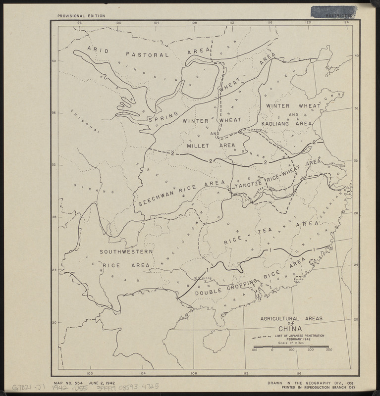
Agricultural areas of China
Agricultural areas of China
×
Item Information
Title:
Agricultural areas of China
Cartographer:
United States. Office of Strategic Services. Geography Division
Name on Item:
drawn in the Geography Div., OSS
Date:
1942
Format:
Maps/Atlases
Location:
Boston Public Library
Norman B. Leventhal Map Center
Collection (local):
Norman B. Leventhal Map Center Collection
Subjects:
Agriculture--China--Maps
China--Maps
Outline maps
Places:
China
Extent:
1 map ; 28 x 24 cm
Permalink:
https://ark.digitalcommonwealth.org/ark:/50959/0z709726s
Terms of Use:
No known copyright restrictions.
No known restrictions on use.
Publisher:
[Washington D.C.] : Reproduction Branch, OSS
Edition:
Provisional edition
Scale:
Scale approximately 1:10,500,000
Language:
English
Notes:
Also shows limit of Japanese penetration February 1942.
"Map no. 554."
"June 2, 1942."
Identifier:
06_01_015265
Call #:
G7821.J1 1942 .U55
Barcode:
39999085934725
show more...
View MODS XML
More Like This
Outline map of the various Boston metropolitan districts
Philippine Islands : [outline map]
United States
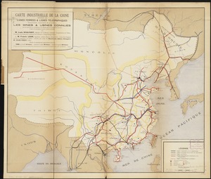
Carte industrielle de la Chine : contenant les lignes ferrées & ...
Find More Like This >>
Tools
Share
Facebook
Pinterest
X
Reddit
Tumblr
Email
Copy link
Add to Folder
Questions/Comments
Cite This Item
IIIF Manifest
Downloads
Primary (full resolution, uncompressed)
(TIF, 21.2 MB)
Large (full resolution)
(JPEG, 1.78 MB)
Medium
(JPEG, 210 KB)