Search


Limit your search
- North and Central America1,823
- United States1,817
- Massachusetts1,713
- Essex (county)1,484
- Lawrence1,414
- Suffolk (county)65
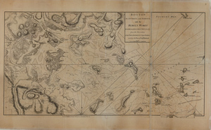
- Boston64
- Norfolk (county)54
- Lawrence History Center Photograph Collection1,854
- Boston Herald-Traveler Photo Morgue237
- Press Photography from the Brearley Collection49
- Parker Collection48
- Tichnor Brothers Postcard Collection41
- College Archives Digital Collections23
- Historical Society of Old Yarmouth Archives and Local History Collection20
- Civil Defense Photographs18