1. Bancroft's map of the Rocky Mountain states, and the Pacific coast Creator: H.H. Bancroft and Company Format: Maps/Atlases Collection: Norman B. Leventhal Map Center Collection Date: 1866 Institution: Boston Public Library
2. Carta geografica general de la republica Mexicana Creator: Mexico. Ministerio de la Guerra Format: Maps/Atlases Collection: Norman B. Leventhal Map Center Collection Date: 1845 Institution: Boston Public Library
3. The Chevron trail through the scenic west Creator: Standard Oil Company of California Format: Maps/Atlases Collection: Norman B. Leventhal Map Center Collection Date: [ca. 1950–1959] Institution: Boston Public Library
4. Great Northern Railway and proprietary lines Creator: Poole Brothers Format: Maps/Atlases Collection: Norman B. Leventhal Map Center Collection Date: [1889–1890] Institution: Boston Public Library
5. Louisiana Creator: Shallus, F. (Francis), Carey, Mathew, 1760-1839, and Carey, Mathew, 1760-1839 Format: Maps/Atlases Collection: Norman B. Leventhal Map Center Collection Date: 1806 Institution: Boston Public Library
6. Map of a tour from Independence to Santa Fé, Chihuahua, Monterey and Matamoros Creator: Wislizenus, F. A. (Frederick Adolph), 1810-1889 Format: Maps/Atlases Collection: Norman B. Leventhal Map Center Collection Date: [1848] Institution: Boston Public Library
7. Map of Oregon and upper California, from the surveys of John Charles Frémont and other authorities Creator: Preuss, Charles, 1803-1854, Edward Weber & Co., United States. Congress. Senate, and Frémont, John Charles, 1813-1890 Format: Maps/Atlases Collection: Norman B. Leventhal Map Center Collection Date: 1848 Institution: Boston Public Library
8. Map of routes for a Pacific railroad Creator: Warren, G. K. (Gouverneur Kemble), 1830-1882 Format: Maps/Atlases Collection: Norman B. Leventhal Map Center Collection Date: 1855 Institution: Boston Public Library
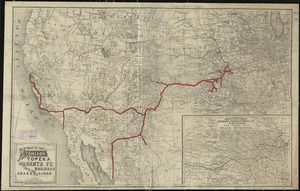
9. Map of the Atchison Topeka and Santa Fe Railroad and its leased lines Creator: Williams, E. Format: Maps/Atlases Collection: Norman B. Leventhal Map Center Collection Date: [1888] Institution: Boston Public Library
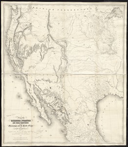
10. Map of the United States and their territories between the Mississippi and the Pacific Ocean; and part of Mexico Creator: United States. Topographical Engineers Format: Maps/Atlases Collection: Norman B. Leventhal Map Center Collection Date: 1850 Institution: Boston Public Library