Skip to search
Skip to main content
Digital Commonwealth
Sign Up / Log In
Search for
Search
Search
Search
Basic
Advanced
Explore
Map
Collections
Institutions
Formats
For Educators
Primary Source Sets
Lesson Plans
Using Primary Sources
Searching Digital Commonwealth
For Institutions
Join Digital Commonwealth
Conferences, Trainings, & Events
How to Contribute Collections
Digitization Services
Board & Committees
Frequently Asked Questions
About
About Digital Commonwealth
News & Announcements
Copyright & Terms of Use
Harmful Content Statement
Partners
API
Contact Us
Boston Public Library
Norman B. Leventhal Map Center Collection
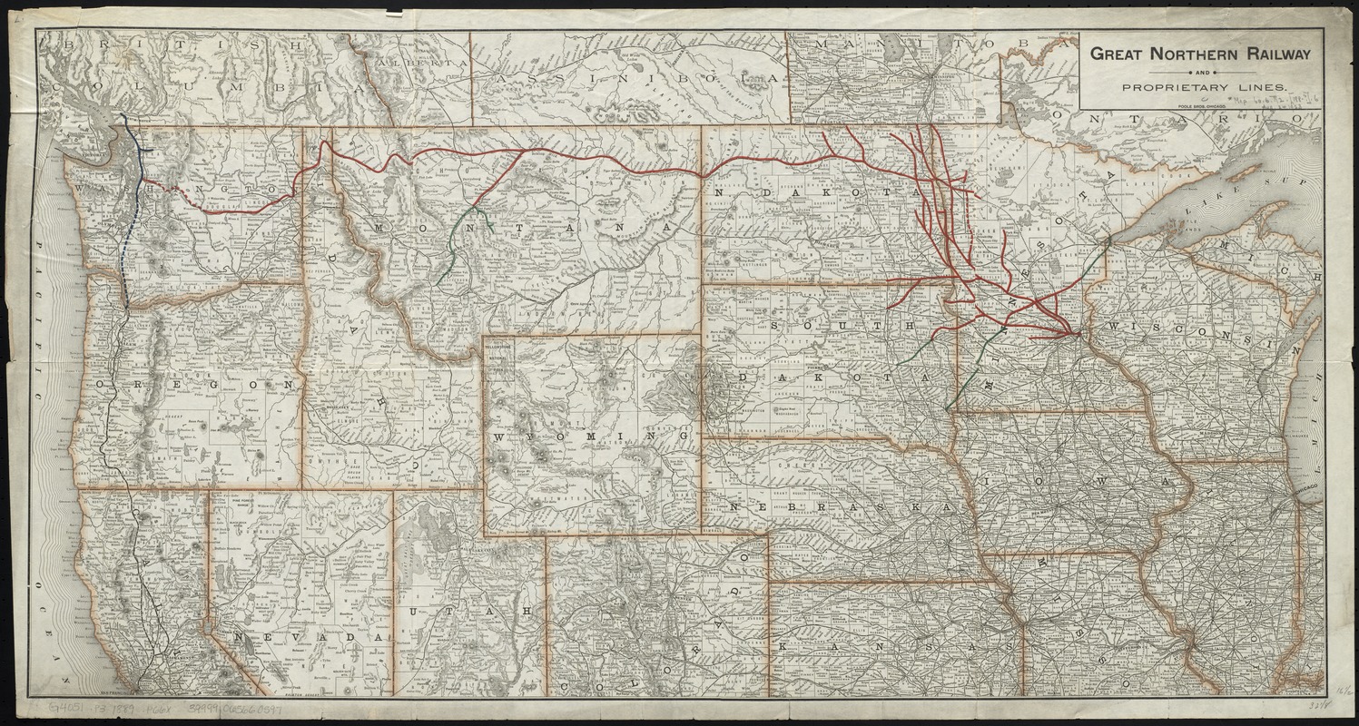
Great Northern Railway and proprietary lines
Great Northern Railway and proprietary lines
×
Item Information
Title:
Great Northern Railway and proprietary lines
Creator:
Poole Brothers
Date:
[1889–1890]
Format:
Maps/Atlases
Location:
Boston Public Library
Norman B. Leventhal Map Center
Collection (local):
Norman B. Leventhal Map Center Collection
Subjects:
Great Northern Railway Company (U.S.)
Railroads--West (U.S.)--Maps
West (U.S.)--Maps
Places:
Western United States
(area)
Extent:
1 map : col. ; 42 x 82 cm.
Permalink:
https://ark.digitalcommonwealth.org/ark:/50959/cj82kp17t
Terms of Use:
No known copyright restrictions.
No known restrictions on use.
Publisher:
Chicago : Poole Bros.
Scale:
Scale [ca. 1:3,500,000]
Language:
English
Notes:
Relief shown by hachures.
Notes (date):
This date is inferred.
Identifier:
06_01_009211
Call #:
G4051.P3 1889 .P66x
Barcode:
39999065660597
show more...
View MODS XML
More Like This
Map of routes for a Pacific railroad
Map of the Atchison Topeka and Santa Fe Railroad and its leased lines
Map seventh division railway mail service
Map showing the Atchison, Topeka and Santa Fe railroad system : ...
Find More Like This >>
Tools
Share
Facebook
Pinterest
X
Reddit
Tumblr
Email
Copy link
Add to Folder
Questions/Comments
Cite This Item
IIIF Manifest
Downloads
Primary (full resolution, uncompressed)
(TIF, 168 MB)
Large (full resolution)
(JPEG, 14.1 MB)
Medium
(JPEG, 607 KB)