Skip to search
Skip to main content
Digital Commonwealth
Sign Up / Log In
Search for
Search
Search
Search
Basic
Advanced
Explore
Map
Collections
Institutions
Formats
For Educators
Primary Source Sets
Lesson Plans
Using Primary Sources
Searching Digital Commonwealth
For Institutions
Join Digital Commonwealth
Conferences, Trainings, & Events
How to Contribute Collections
Digitization Services
Board & Committees
Frequently Asked Questions
About
About Digital Commonwealth
News & Announcements
Copyright & Terms of Use
Harmful Content Statement
Partners
API
Contact Us
Boston Public Library
Norman B. Leventhal Map Center Collection
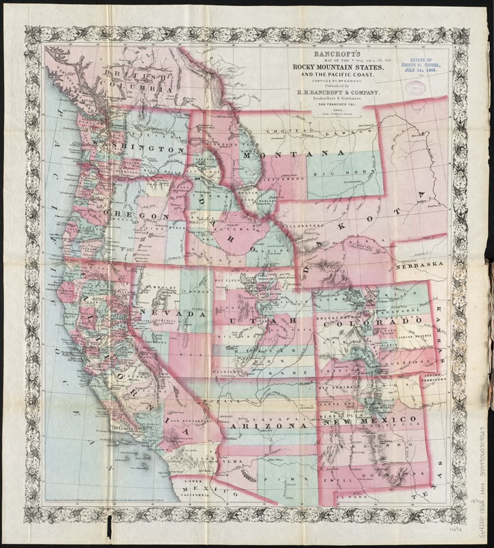
Bancroft's map of the Rocky Mountain states, and the Pacific coast
Bancrofts map of the Rocky Mountain states, and the Pacific coast
×
Item Information
Title:
Bancroft's map of the Rocky Mountain states, and the Pacific coast
Title (alt.):
Map of the Rocky Mountain states and the Pacific coast
Creator:
H.H. Bancroft and Company
Name on Item:
compiled by Wm. H. Knight.
Date:
1866
Format:
Maps/Atlases
Location:
Boston Public Library
Norman B. Leventhal Map Center
Collection (local):
Norman B. Leventhal Map Center Collection
Subjects:
West (U.S.)--Maps
Places:
Western United States
(area)
Extent:
1 map : col. ; 48 x 42 cm.
Permalink:
https://ark.digitalcommonwealth.org/ark:/50959/cj82kv273
Terms of Use:
No known copyright restrictions.
No known restrictions on use.
Publisher:
San Francisco : H.H. Bancroft & Co.
Scale:
Scale [1:4,752,000]. 75 mi. to an in.
Language:
English
Notes:
Relief shown by hachures and spot heights.
Identifier:
06_01_009807
Call #:
G4210 1866 .H14
Barcode:
39999065709527
show more...
View MODS XML
More Like This
Carta geografica general de la republica Mexicana
The Chevron trail through the scenic west
Great Northern Railway and proprietary lines
Louisiana
Find More Like This >>
Tools
Share
Facebook
Pinterest
X
Reddit
Tumblr
Email
Copy link
Add to Folder
Questions/Comments
Cite This Item
IIIF Manifest
Downloads
Primary (full resolution, uncompressed)
(TIF, 124 MB)
Large (full resolution)
(JPEG, 10.4 MB)
Medium
(JPEG, 267 KB)
GeoTIFF (georeferenced)
(TIF, 179 MB)