Skip to search
Skip to main content
Digital Commonwealth
Sign Up / Log In
Search for
Search
Search
Search
Basic
Advanced
Explore
Map
Collections
Institutions
Formats
For Educators
Primary Source Sets
Lesson Plans
Using Primary Sources
Searching Digital Commonwealth
For Institutions
Join Digital Commonwealth
Conferences, Trainings, & Events
How to Contribute Collections
Digitization Services
Board & Committees
Frequently Asked Questions
About
About Digital Commonwealth
News & Announcements
Copyright & Terms of Use
Harmful Content Statement
Partners
API
Contact Us
Boston Public Library
Norman B. Leventhal Map & Education Center Collection
/
Boston and New England Maps (Collection of Distinction)
/
Maritime Charts and Atlases (Collection of Distinction)
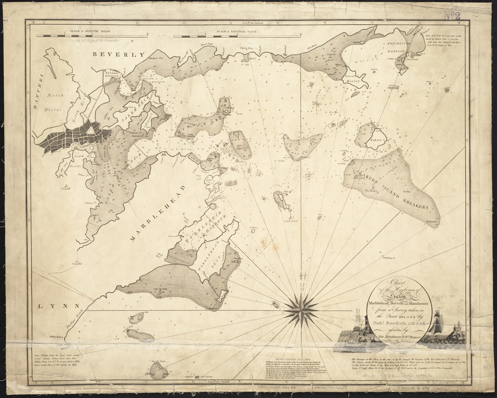
Chart of the harbours of Salem, Marblehead, Beverly and Manchester : from a survey taken in the years 1804, 5 & 6
Chart of the harbours of Salem, Marblehead, Beverly and Manchester
×
Item Information
Title:
Chart of the harbours of Salem, Marblehead, Beverly and Manchester : from a survey taken in the years 1804, 5 & 6
Creator:
Bowditch, Nathaniel, 1773-1838
Name on Item:
by Nathl. Bowditch ; assisted by Geo. Burchmore & Wm. Ropes 3d.
Date:
1834
Format:
Maps/Atlases
Location:
Boston Public Library
Norman B. Leventhal Map & Education Center
Collection (local):
Norman B. Leventhal Map & Education Center Collection
Subjects:
Nautical charts--Massachusetts--Beverly
Nautical charts--Massachusetts--Manchester
Nautical charts--Massachusetts--Marblehead
Nautical charts--Massachusetts--Salem
Harbors--Massachusetts--Maps
Salem (Mass.)--Maps
Marblehead (Mass.)--Maps
Beverly (Mass.)--Maps
Manchester (Mass.)--Maps
North Shore (Mass. : Coast)--Maps
Places:
Massachusetts
>
Essex (county)
>
Beverly
Massachusetts
>
Essex (county)
>
Manchester
Massachusetts
>
Essex (county)
>
Salem
Massachusetts
>
Essex (county)
>
Marblehead
Extent:
1 chart ; 53 x 63 cm.
Permalink:
https://ark.digitalcommonwealth.org/ark:/50959/9s1619634
Terms of Use:
No known copyright restrictions.
No known restrictions on use.
Publisher:
S.l : [s.n.]
Edition:
2nd ed. /
Scale:
Scale 1:217,800
Language:
English
Notes:
Depths shown by soundings.
Relief shown pictorially.
Engraved by Hooker & Fairman.
Identifier:
06_01_003275
Call #:
G3762.S24P5 1834 .B6
Barcode:
39999059000024
show more...
View MODS XML
More Like This
Chart of the harbours of Salem, Marblehead, Beverly, and ...
Atlas of Essex County, Massachusetts
Map of the Beverly and Manchester shore Massachusetts
Atlas of the boundaries of the city of Salem and towns of Danvers, ...
Find More Like This >>
Tools
Share
Facebook
Pinterest
X
Reddit
Tumblr
Email
Copy link
Add to Folder
Questions/Comments
Cite This Item
IIIF Manifest
Downloads
Primary (full resolution, uncompressed)
(TIF, 160 MB)
Large (full resolution)
(JPEG, 13.4 MB)
Medium
(JPEG, 275 KB)