Skip to search
Skip to main content
Digital Commonwealth
Sign Up / Log In
Search for
Search
Search
Search
Basic
Advanced
Explore
Map
Collections
Institutions
Formats
For Educators
Primary Source Sets
Lesson Plans
Using Primary Sources
Searching Digital Commonwealth
For Institutions
Join Digital Commonwealth
Conferences, Trainings, & Events
How to Contribute Collections
Digitization Services
Board & Committees
Frequently Asked Questions
About
About Digital Commonwealth
News & Announcements
Copyright & Terms of Use
Harmful Content Statement
Partners
API
Contact Us
Boston Public Library
Norman B. Leventhal Map & Education Center Collection
/
Boston Redevelopment Authority Collection
/
Urban Maps (Collection of Distinction)
/
Boston and New England Maps (Collection of Distinction)
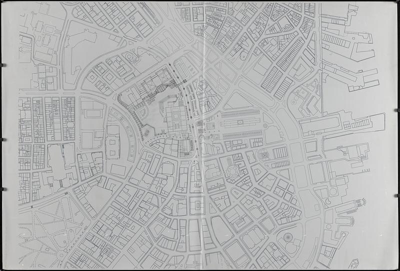
Landscaping plan of City Hall Plaza, Boston
Landscaping plan of City Hall Plaza, Boston
×
Item Information
Title:
Landscaping plan of City Hall Plaza, Boston
Description:
Outline map of the Government Center area showing buildings and streets printed on verso of translucent mylar, with manuscript annotations in ink and pencil showing trees and landscaping around City Hall Plaza on recto of sheet.
Date:
[ca. 1988]
Format:
Maps/Atlases
Genre:
Outline maps
Manuscript maps
Location:
Boston Public Library
Norman B. Leventhal Map & Education Center
Collection (local):
Norman B. Leventhal Map & Education Center Collection
Series:
Boston Redevelopment Authority Maps & Manuscript Plans Collection
Subjects:
City planning--Massachusetts--Boston--Maps
Landscape gardening--Massachusetts--Boston--Maps
Buildings--Massachusetts--Boston--Maps
Urban renewal--Massachusetts--Boston--Maps
Government Center (Boston, Mass.)--Maps
Places:
Massachusetts
>
Suffolk (county)
>
Boston
Boston City Hall Plaza
Government Center
Extent:
1 map : on plastic ; sheet 92 x 135 cm
Permalink:
https://ark.digitalcommonwealth.org/ark:/50959/7w62hs23k
Terms of Use:
No known copyright restrictions.
No known restrictions on use.
Place of origin:
[Boston]
Scale:
Scale approximately 1:1,200
Language:
English
Identifier:
06_01_017836
Call #:
BRA MAP FOLDER 33 no.3
Barcode:
30000007747782
show more...
View MODS XML
More Like This
Cooperative housing : Whitney Street
Government Center project Mass. r-35 : parcel 7 & subway structure ...
Government Center project no. Mass. r-35 : building deficiencies map
Government Center project no. Mass. r-35 : disposition parcel map
Find More Like This >>
Tools
Share
Facebook
Pinterest
X
Reddit
Tumblr
Email
Copy link
Add to Folder
Questions/Comments
Cite This Item
IIIF Manifest
Downloads
Primary (full resolution, uncompressed)
(TIF, 254 MB)
Large (full resolution)
(JPEG, 21.3 MB)
Medium
(JPEG, 99.5 KB)