Skip to search
Skip to main content
Digital Commonwealth
Sign Up / Log In
Search for
Search
Search
Search
Basic
Advanced
Explore
Map
Collections
Institutions
Formats
For Educators
Primary Source Sets
Lesson Plans
Using Primary Sources
Searching Digital Commonwealth
For Institutions
Join Digital Commonwealth
Conferences, Trainings, & Events
How to Contribute Collections
Digitization Services
Board & Committees
Frequently Asked Questions
About
About Digital Commonwealth
News & Announcements
Copyright & Terms of Use
Harmful Content Statement
Partners
API
Contact Us
Boston Public Library
Boston Redevelopment Authority Collection
/
Urban Maps (Collection of Distinction)
/
Boston and New England Maps (Collection of Distinction)
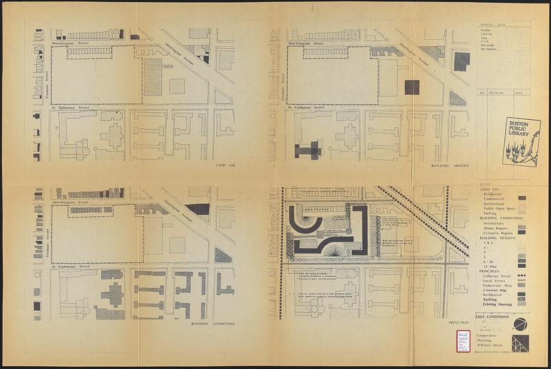
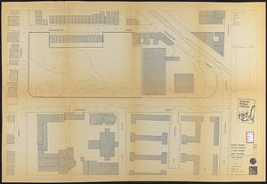
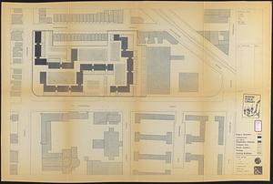
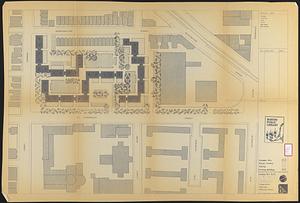
Cooperative housing : Whitney Street
Viewing image 1 of 4
Next >
Cooperative housing
×
Next
Item Information
Title:
Cooperative housing : Whitney Street
Description:
Part of a collection of material concerning a proposal for cooperative housing in Boston's Mission Hill section of its Roxbury neighborhood.
Cartographer:
Boston Redevelopment Authority
Date:
May 15, 1963
Format:
Maps/Atlases
Location:
Boston Public Library
Central Library in Copley Square
Collection (local):
Boston Public Library Collection
Subjects:
Mission Hill (Boston, Mass.)--Maps
Buildings--Massachusetts--Boston--Maps
Land use--Massachusetts--Boston--Maps
Landscape gardening--Massachusetts--Boston--Maps
City planning--Massachusetts--Boston--Maps
Urban renewal--Massachusetts--Boston--Maps
Places:
Suffolk (county)
>
Boston
Mission Hill
Extent:
4 maps ; sheets 61 x 92 cm and 56 x 85 cm
Permalink:
https://ark.digitalcommonwealth.org/ark:/50959/xp68nx902
Terms of Use:
No known copyright restrictions.
No known restrictions on use.
Publisher:
Boston : Boston Redevelopment Authority
Scale:
Scale 1:1,200
Scale 1:480
Language:
English
Table of Contents:
Exist. conditions
Topography
Site plan
Landscape plan
Referenced by:
Accompanying text
Notes:
Existing conditions map consists of 4 maps: land use, building heights, building conditions, and principles.
Oriented with north to the upper right.
Identifier:
06_01_017742
06_01_017743
06_01_017744
06_01_017745
Call #:
BRA/FOLIO/97 maps
Barcode:
mq6311180
show more...
View MODS XML
More Like This
Parker Hill-Fenway urban renewal area r-48 : proposed land use
Parker Hill-Fenway urban renewal area r-48 : existing land use
Parker Hill-Fenway urban renewal area r-48 : building conditions
Parker Hill-Fenway urban renewal area r-48 : existing building ...
Find More Like This >>
Tools
Share
Facebook
Pinterest
X
Reddit
Tumblr
Email
Copy link
Add to Folder
Questions/Comments
Cite This Item
IIIF Manifest
Downloads
Primary (full resolution, uncompressed)
(TIF, multi-file ZIP, 392 MB)
Large (full resolution)
(JPEG, multi-file ZIP, 3.47 MB)
Medium
(JPEG, multi-file ZIP, 279 KB)