Skip to search
Skip to main content
Skip to first result
Digital Commonwealth
Folders
Sign Up / Log In
Search for
Search
Search
Search
Basic
Advanced
Explore
Map
Collections
Institutions
Formats
For Educators
Primary Source Sets
Lesson Plans
Using Primary Sources
Searching Digital Commonwealth
For Institutions
Join Digital Commonwealth
Conferences, Trainings, & Events
How to Contribute Collections
Digitization Services
Board & Committees
Frequently Asked Questions
About
About Digital Commonwealth
News & Announcements
Copyright & Terms of Use
Harmful Content Statement
Partners
API
Contact Us
Search
Search Constraints
Start Over
Save Search
Your search:
More Like
commonwealth-oai:ww72bj77b
✖
Remove constraint More Like: commonwealth-oai:ww72bj77b
« Prev.
|
261
-
280
of
368
|
Next »
Sort
by relevance
relevance
title
date (asc)
date (desc)
Number of results to display per page
20
per page
per page
10
per page
20
per page
50
per page
100
per page
View results as:
List
list view
Maps
map view
Gallery
grid view
Search Results
261.
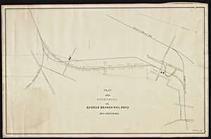
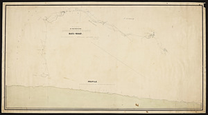
Plan of the extension of the Saugus Branch railroad
262.
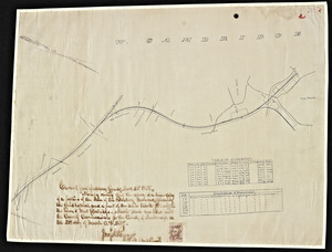
Plan of the Fitchburg Railway through West Cambridge as filed with the Middlesex County Commissioners.
263.
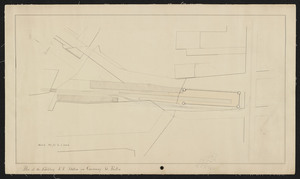
Plan of the Fitchburg R.R. station on Causeway St., Boston.
264.
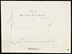
Plan of the Grand Hotel branch railroad / E. Appleton, civil engineer.
265.
Plan of the Grand Junction railroad showing its connections with the Eastern, Maine extension, Fitchburg and Lowell railroads /...
266.
Plan of the junction of Cape Cod branch railroad with Fall River railroad.
267.
Plan of the Lake Quanapowitt Railroad in South Reading.
268.
Plan of the line of a proposed railroad from Gloucester village to Lanesville / T. & J. Doane, civil engineers and surveyors.
269.
Plan of the location of the Boston & Maine Railroad from the Mill Pond in Charleston northerly to the canal in Somerville
270.
Plan of the location of the Boston & Maine Rail-Road from the Mill Pond in Charlestown northerly to the Middlesex Canal in...
271.
Plan of the location of the Norfolk County railroad between Blackstone and Dedham, January 1849 / Joseph N. Cunningham,...
272.
Plan of the location of the Norfolk County Railroad between Dedham and Blackstone.
273.
Plan of the Middlesex railroad
274.
Plan of the Mystic River Railroad
275.
Plan of the premises of the Boston and Maine and Eastern railroads in the city of Boston north of Causeway Street.
276.
Plan of the proposed Ashburnham-branch rail-road / as surveyed by Joseph H. Walker.
277.
A plan of the proposed change of that section of the O.C. & F.R. R.R. located between Kneeland Street, Boston and Dorchester...
278.
Plan of the proposed extension of the Granite Railway to the Old Colony & Newport Railway / S.L. Minot, engineer.
279.
Plan of the proposed extension of the New Bedford and Taunton railroad from the present terminus in New Bedford to the wharves...
280.
Plan of the proposed location for a railroad from Amesbury, Massachusetts to Epping, New Hampshire via Exeter, New Hampshire...
« Previous
Next »
1
2
…
10
11
12
13
14
15
16
17
18
19
Limit your search
Subject
Railroads--Massachusetts
59
Railroads--Massachusetts--Maps
13
Massachusetts--Maps
9
Old Colony Railroad
8
Boston and Maine Railroad--Maps
7
Massachusetts. Board of Railroad Commissioners
7
Massachusetts. Public Service Commission
7
Public utilities--Massachusetts
7
more
Subject
»
Place
North and Central America
368
United States
368
Massachusetts
356
Middlesex (county)
91
Suffolk (county)
72
Boston
71
Norfolk (county)
46
Essex (county)
43
more
Place
»
Format
Maps/Atlases
269
Documents
99
Date
View distribution
Current results range from
1827
to
1919
Date range begin
Date range end
View larger »
Unknown
56
Collection
Massachusetts Board of Railroad Commissioners
368
Institution
State Library of Massachusetts
368