Skip to search
Skip to main content
Digital Commonwealth
Sign Up / Log In
Search for
Search
Search
Search
Basic
Advanced
Explore
Map
Collections
Institutions
Formats
For Educators
Primary Source Sets
Lesson Plans
Using Primary Sources
Searching Digital Commonwealth
For Institutions
Join Digital Commonwealth
Conferences, Trainings, & Events
How to Contribute Collections
Digitization Services
Board & Committees
Frequently Asked Questions
About
About Digital Commonwealth
News & Announcements
Copyright & Terms of Use
Harmful Content Statement
Partners
API
Contact Us
State Library of Massachusetts
Massachusetts Board of Railroad Commissioners
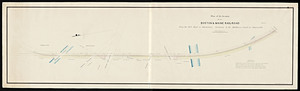
Plan of the location of the Boston & Maine Railroad from the Mill Pond in Charleston northerly to the canal in Somerville
View this item online at State Library of Massachusetts
Item Information
Title:
Plan of the location of the Boston & Maine Railroad from the Mill Pond in Charleston northerly to the canal in Somerville
Format:
Maps/Atlases
Location:
State Library of Massachusetts
Collection (local):
Massachusetts Board of Railroad Commissioners
Series:
Maps
Subjects:
Boston and Maine Railroad--Maps
Places:
Massachusetts
>
Suffolk (county)
>
Boston
Link to Item:
http://archives.lib.state.ma.us/handle/2452/50650
Terms of Use:
Rights status not evaluated.
Contact host institution for more information.
Notes:
Published in the 19th century.
1 map 14 x 50 in.
Map Mass. R.R. #186
Identifier:
esl40031400
show more...
View MODS XML
More Like This
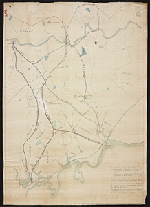
From Boston to the Arch bridge at Lowell via the Boston and Maine ...
[Map of Boston to Lowell Railroad, also Lowell and Lawrence and ...
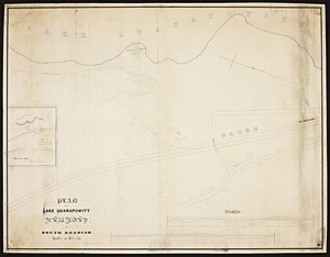
Plan of the Lake Quanapowitt Railroad in South Reading.
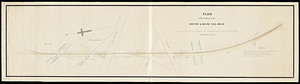
Plan of the location of the Boston & Maine Rail-Road from the Mill ...
Find More Like This >>
Tools
Share
Facebook
Pinterest
X
Reddit
Tumblr
Email
Copy link
Add to Folder
Questions/Comments
Cite This Item
![[Map of Boston to Lowell Railroad, also Lowell and Lawrence and Salem and Lowell Railroads].](https://bpldcassets.blob.core.windows.net/derivatives/metadata/commonwealth-oai:3b591r39g/image_thumbnail_300.jpg)