Skip to search
Skip to main content
Skip to first result
Digital Commonwealth
Folders
Sign Up / Log In
Search for
Search
Search
Search
Basic
Advanced
Explore
Map
Collections
Institutions
Formats
For Educators
Primary Source Sets
Lesson Plans
Using Primary Sources
Searching Digital Commonwealth
For Institutions
Join Digital Commonwealth
Conferences, Trainings, & Events
How to Contribute Collections
Digitization Services
Board & Committees
Frequently Asked Questions
About
About Digital Commonwealth
News & Announcements
Copyright & Terms of Use
Harmful Content Statement
Partners
API
Contact Us
Search
Search Constraints
Start Over
Save Search
Your search:
More Like
commonwealth-oai:ww72bf933
✖
Remove constraint More Like: commonwealth-oai:ww72bf933
« Prev. |
1
-
50
of
433
|
Next »
Sort
by date (desc)
relevance
title
date (asc)
date (desc)
Number of results to display per page
50
per page
per page
10
per page
20
per page
50
per page
100
per page
View results as:
List
list view
Maps
map view
Gallery
grid view
Search Results
1.
Back Bay view of the world
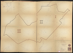
2.
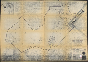
Area plan as of May 1962
3.
Profile of Huntington Avenue/St. James Avenue from Harcourt Street to Berkeley Street
4.
Sears Park conceptual site plan with historic waterway
5.
FPIR/FEIR Olmsted Plaza : a redevelopment of the Sears property, 309 Park Drive/201 Brookline Avenue in the Fenway
6.
John Hancock office and parking garage complex, Boston, Massachusetts
7.
Back Bay Fens master plan
8.
The Riverway master plan
9.
Wastewater system map, Boston proper, sheet no. 21h
10.
Wastewater system map, Boston proper, sheet no. 23h
11.
Water distribution system map, Boston proper, sheet no. 21h
12.
Water distribution system map, Boston proper, sheet no. 22h
13.
Water system map, Boston proper, sheet no. 22h
14.
St. James Avenue garage parcel
15.
Boston University buildings
16.
Outline map and view of the Prudential Center area
17.
Boylston Street : Fenway to Massachusetts Avenue
18.
Parcel 13 rehabilitation
19.
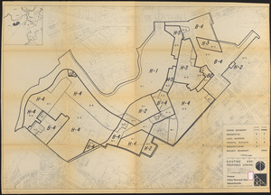
Fenway urban renewal area Massachusetts : disposition parcels
20.
Boylston Street improvements
21.
Back Bay study landscape plan
22.
Back Bay study
23.
Proposed land use plan and circulation system
24.
Recommended geometrics plan : Back Bay study area
25.
Fenway urban renewal area Massachusetts : disposition parcels
26.
Fenway urban renewal area Massachusetts : building deficiences and proposed treatment area
27.
Fenway urban renewal area Massachusetts : property map
28.
Fenway urban renewal area Massachusetts : existing and proposed zoning
29.
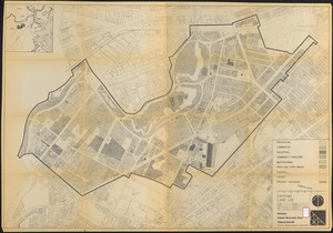
Fenway urban renewal area Massachusetts : existing land use
30.
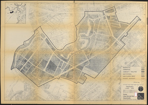
Fenway urban renewal area Massachusetts : proposed land use
31.
Fenway urban renewal area Massachusetts : disposition parcels
32.
Back Bay zoning district map
33.
Parker Hill-Fenway urban renewal area r-48 : existing population density
34.
Back Bay urban renewal area r-47 : land use plan
35.
Back Bay urban renewal area r-47 : building conditions
36.
Back Bay urban renewal area r-47 : building conditions
37.
Back Bay urban renewal area r-47 : community facilities & circulation plan
38.
Back Bay urban renewal area r-47 : land use plan
39.
Back Bay urban renewal area r-47 : existing land use
40.
Back Bay urban renewal area r-47 : existing land use
41.
Back Bay project no. Mass R-47
42.
Back Bay project no. Mass. R-47 : police signal system, fire alarm system and M.T.A. facilities
43.
Parker Hill-Fenway urban renewal area r-48 : building conditions
44.
Parker Hill-Fenway urban renewal area r-48 : existing building coverage
45.
Parker Hill-Fenway urban renewal area r-48 : existing and proposed community facilities
46.
Parker Hill-Fenway urban renewal area r-48 : proposed circulation
47.
Parker Hill-Fenway urban renewal area r-48 : existing institutions
48.
Parker Hill-Fenway urban renewal area r-48 : existing circulation
49.
Parker Hill-Fenway urban renewal area r-48 : proposed land use
50.
Parker Hill-Fenway urban renewal area r-48 : existing land use
« Previous
Next »
1
2
3
4
5
…
8
9
Limit your search
Subject
Real property--Massachusetts--Boston--Maps
195
Landowners--Massachusetts--Boston--Maps
192
Fenway (Boston, Mass.)--Maps
164
Boston (Mass.)--Maps
139
Back Bay (Boston, Mass.)--Maps
129
Hoosac Tunnel (Mass.)--Photographs
112
Tunnels--Massachusetts--Photographs
67
City planning--Massachusetts--Boston--Maps
62
more
Subject
»
Place
North and Central America
433
United States
433
Massachusetts
343
Boston
289
Suffolk (county)
289
Back Bay
118
Fens
79
Roxbury
36
more
Place
»
Format
Maps/Atlases
321
Photographs
112
Drawings/Illustrations
1
Available to use
No known restrictions
284
Creative Commons license
1
Date
View distribution
Current results range from
1800
to
2017
Date range begin
Date range end
View larger »
Collection
Boston and New England Maps (Collection of Distinction)
283
Urban Maps (Collection of Distinction)
281
Norman B. Leventhal Map Center Collection
229
Other
145
Boston Redevelopment Authority Collection
68
Massachusetts Board of Harbor and Land Commissioners
3
Institution
Boston Public Library
285
State Library of Massachusetts
148