Skip to search
Skip to main content
Digital Commonwealth
Sign Up / Log In
Search for
Search
Search
Search
Basic
Advanced
Explore
Map
Collections
Institutions
Formats
For Educators
Primary Source Sets
Lesson Plans
Using Primary Sources
Searching Digital Commonwealth
For Institutions
Join Digital Commonwealth
Conferences, Trainings, & Events
How to Contribute Collections
Digitization Services
Board & Committees
Frequently Asked Questions
About
About Digital Commonwealth
News & Announcements
Copyright & Terms of Use
Harmful Content Statement
Partners
API
Contact Us
Boston Public Library
Boston Redevelopment Authority Collection
/
Urban Maps (Collection of Distinction)
/
Boston and New England Maps (Collection of Distinction)
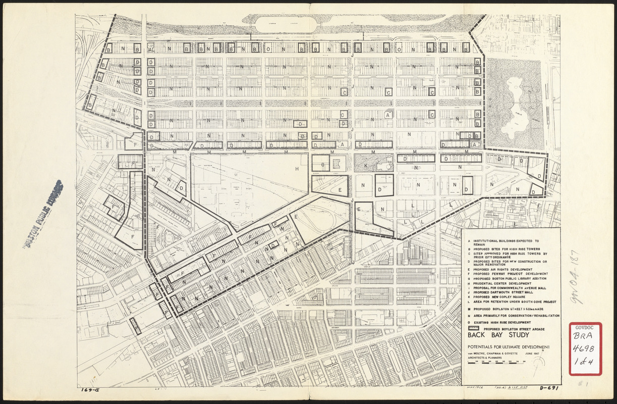
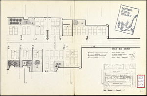
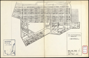
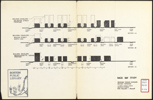
Back Bay study
Viewing image 1 of 4
Next >
Back Bay study
×
Next
Item Information
Title:
Back Bay study
Description:
Accompanies a development plan for Back Bay.
Cartographer:
Von Moltke, Chapman and Goyette
Date:
June 1967
Format:
Maps/Atlases
Location:
Boston Public Library
Central Library in Copley Square
Collection (local):
Boston Public Library Collection
Subjects:
Alleys--Massachusetts--Boston--Maps
Arlington Street (Boston, Mass.)--Maps
Buildings--Massachusetts--Boston--Maps
Commonwealth Avenue (Boston, Mass.)--Maps
Dartmouth Street (Boston, Mass.)--Maps
Massachusetts Avenue (Boston, Mass.)--Maps
City planning--Massachusetts--Boston--Maps
Zoning--Massachusetts--Boston--Maps
Boylston Street (Boston, Mass.)--Maps
Back Bay (Boston, Mass.)--Maps
Buildings--Height Restrictions--Massachusetts--Boston--Maps
Prudential Center (Boston, Mass.)
Boston Public Library
Places:
Massachusetts
>
Suffolk (county)
>
Boston
>
Back Bay
Extent:
1 map ; 27 x 35 cm
Permalink:
https://ark.digitalcommonwealth.org/ark:/50959/7h14cv47w
Terms of Use:
No known copyright restrictions.
No known restrictions on use.
Publisher:
[Boston] : Von Moltke, Chapman and Goyette
Scale:
Scales differ
Language:
English
Referenced by:
http://bpl.bibliocommons.com/item/show/1031697075
Notes:
Oriented with north to the upper right.
Manuscript in lower right: May 1966 (no. 4) base map.
Identifier:
06_01_017174A
06_01_017174B
06_01_017174C
06_01_017174D
Call #:
BRA/4698
Barcode:
mq6328367
show more...
View MODS XML
More Like This
Back Bay study landscape plan
Boylston Street improvements
Plan for Boston
Back Bay zoning district map
Find More Like This >>
Tools
Share
Facebook
Pinterest
X
Reddit
Tumblr
Email
Copy link
Add to Folder
Questions/Comments
Cite This Item
IIIF Manifest
Downloads
Primary (full resolution, uncompressed)
(TIF, multi-file ZIP, 121 MB)
Large (full resolution)
(JPEG, multi-file ZIP, 1.07 MB)
Medium
(JPEG, multi-file ZIP, 1.17 MB)