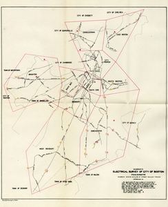
Skip to search
Skip to main content
Skip to first result
Digital Commonwealth
Folders
Sign Up / Log In
Search for
Search
Search
Search
Basic
Advanced
Explore
Map
Collections
Institutions
Formats
For Educators
Primary Source Sets
Lesson Plans
Using Primary Sources
Searching Digital Commonwealth
For Institutions
Join Digital Commonwealth
Conferences, Trainings, & Events
How to Contribute Collections
Digitization Services
Board & Committees
Frequently Asked Questions
About
About Digital Commonwealth
News & Announcements
Copyright & Terms of Use
Harmful Content Statement
Partners
API
Contact Us
Search
Search Constraints
Start Over
Save Search
Your search:
More Like
commonwealth:wd376720z
✖
Remove constraint More Like: commonwealth:wd376720z
« Prev. |
1
-
20
of
12,571
|
Next »
Sort
by relevance
relevance
title
date (asc)
date (desc)
Number of results to display per page
20
per page
per page
10
per page
20
per page
50
per page
100
per page
View results as:
List
list view
Maps
map view
Gallery
grid view
Search Results
1.
Central part of Boston Elevated Railway system showing connections
2.
Electrical Survey of City of Boston
3.
Map of Boston Showing the Location of Electric Car Tracks
4.
Map of Boston Showing the Location of Electric Car Tracks
5.
Boston elevated railway system
6.
Map of Boston
7.
Map of Boston proper
8.
[Map of Boston, showing surface lines, proposed elevated lines, connecting surface lines and route of subway
9.
Map showing horse rail roads and the surface steam roads with 104 stations in and around Boston : including 91 surface steam...
10.
Proposed street railroad over the Back Bay to Brookline
11.
Rail road map : showing the street rail road routes in and leading from Boston, with the terminus of each road in suburban...
12.
Railroad map of all street and steam railroads in Boston and vicinity
13.
Annexation map
14.
Boston and its suburban drives
15.
[Boston and Northwestern Junction Railroad]
16.
Boston and surroundings
17.
Boston and vicinity
18.
Boston and vicinity : 1893
19.
J. Schedler's relief map of Boston and environs
20.
Map of Boston 1875 : from A. Williams & Cos. map of Boston and the adjacent country, 1872
« Previous
Next »
1
2
3
4
5
…
628
629
Limit your search
Subject
Real property--Massachusetts--Boston--Maps
2,298
Boston (Mass.)--Maps
2,181
Landowners--Massachusetts--Boston--Maps
2,126
Boston Elevated Railway Company
1,273
Roxbury (Boston, Mass.)--Maps
353
Boston (Mass.)
330
Dorchester (Boston, Mass.)--Maps
317
Local transit
313
more
Subject
»
Place
North and Central America
9,345
United States
8,088
Suffolk (county)
4,714
Boston
4,574
Massachusetts
4,567
Europe
963
Middlesex (county)
669
Roxbury
544
more
Place
»
Format
Maps/Atlases
11,261
Photographs
1,216
Manuscripts
217
Prints
72
Books
36
Posters
25
Objects/Artifacts
17
Drawings/Illustrations
12
more
Format
»
Available to use
No known restrictions
11,154
Creative Commons license
98
Date
View distribution
Current results range from
1482
to
2023
Date range begin
Date range end
View larger »
Unknown
13
Collection
Norman B. Leventhal Map Center Collection
11,056
Boston and New England Maps (Collection of Distinction)
5,262
Urban Maps (Collection of Distinction)
4,967
Maritime Charts and Atlases (Collection of Distinction)
750
American Revolutionary War-Era Maps (Collection of Distinction)
632
Boston Elevated Photographs: North Station Lechmere
204
Boston Redevelopment Authority Collection
195
Boston Elevated Photographs: Accidents
182
more
Collection
»
Institution
Boston Public Library
11,251
Boston City Archives
1,112
Salem State University Archives and Special Collections
77
State Library of Massachusetts
56
Historic New England
29
Private Collection
22
American Antiquarian Society
13
Phillips Academy
8
more
Institution
»