Skip to search
Skip to main content
Digital Commonwealth
Folders
Sign Up / Log In
Search for
Search
Search
Search
Basic
Advanced
Explore
Map
Collections
Institutions
Formats
For Educators
Primary Source Sets
Lesson Plans
Using Primary Sources
Searching Digital Commonwealth
For Institutions
Join Digital Commonwealth
Conferences, Trainings, & Events
How to Contribute Collections
Digitization Services
Board & Committees
Frequently Asked Questions
About
About Digital Commonwealth
News & Announcements
Copyright & Terms of Use
Harmful Content Statement
Partners
API
Contact Us
Boston Public Library
Norman B. Leventhal Map & Education Center Collection
/
Urban Maps (Collection of Distinction)
/
Boston and New England Maps (Collection of Distinction)
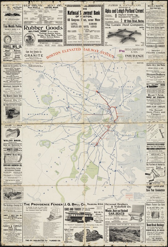
Boston elevated railway system
Boston elevated railway system
×
Item Information
Title:
Boston elevated railway system
Name on Item:
H.B. Andrews, C.E.
Date:
1899
Format:
Maps/Atlases
Location:
Boston Public Library
Norman B. Leventhal Map & Education Center
Collection (local):
Norman B. Leventhal Map & Education Center Collection
Subjects:
Street-railroads--Massachusetts--Boston--Maps
Boston (Mass.)--Maps
Places:
Massachusetts
>
Suffolk (county)
>
Boston
Extent:
1 map : col. ; 97 x 77 cm., on sheet 152 x 103 cm.
Permalink:
https://ark.digitalcommonwealth.org/ark:/50959/cj82m212w
Terms of Use:
No known copyright restrictions.
No known restrictions on use.
Publisher:
[S.l.] : F.W. Dudley
Scale:
Scale 1:18,000.
Language:
English
Notes:
Contains numerous advertisements.
Identifier:
06_01_004734
Call #:
G3764.B6P33 1899 .B67x
Barcode:
39999059007185
show more...
View MODS XML
More Like This
Central part of Boston Elevated Railway system showing connections
Map of Boston
Map of Boston and vicinity showing tracks operated by the Boston ...
Map of Boston proper
Find More Like This >>
Tools
Share
Facebook
Pinterest
X
Reddit
Tumblr
Email
Copy link
Add to Folder
Questions/Comments
Cite This Item
IIIF Manifest
Downloads
Primary (full resolution, uncompressed)
(TIF, 405 MB)
Large (full resolution)
(JPEG, 34 MB)
Medium
(JPEG, 226 KB)
GeoTIFF (georeferenced)
(TIF, 530 MB)