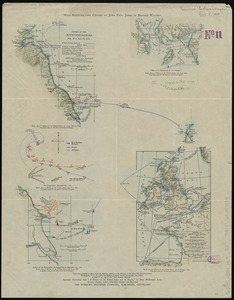
1. Maps illustrating cruises of John Paul Jones in British waters : [Great Britain and Ireland] Creator: Eastman, Annie Henderson. Format: Maps/Atlases Collection: Norman B. Leventhal Map Center Collection Date: [ca. 1909] Institution: Boston Public Library
2. A mapp of New England Creator: Seller, John, fl. 1658-1698 Format: Maps/Atlases Collection: Norman B. Leventhal Map Center Collection Date: [1900–1999] Institution: Boston Public Library
3. Sketch A showing the progress of the survey in section no. 1 from 1844 to 1881 Creator: U.S. Coast and Geodetic Survey Format: Maps/Atlases Collection: Sidney R. Knafel Map Collection at Phillips Academy Date: 1881 Institution: Phillips Academy
4. A map of the country adjacent to the north boundary line of the colony of Rhode Island as the same was run by commissioners appointed for that purpose by the general... Creator: Harrison, Joseph. Format: Maps/Atlases; Manuscripts Collection: American Revolutionary War-Era Maps (Collection of Distinction) / Boston and New England Maps (Collection of Distinction) / Norman B. Leventhal Map Center Collection Date: [1880?–1889?] Institution: Boston Public Library
5. Old Colony Railroad and connections Creator: Winslow, E. N.; J.H. Bufford's Lith. Format: Maps/Atlases Collection: Sidney R. Knafel Map Collection at Phillips Academy Date: [ca. 1872–1888] Institution: Phillips Academy
6. Barnstable County, Dukes County and Nantucket Island, Massachusetts Creator: Walling, Henry Francis, 1825-1888 Format: Maps/Atlases Collection: Sidney R. Knafel Map Collection at Phillips Academy Date: [1871] Institution: Phillips Academy
7. Old Colony & Newport railway and its connections Format: Maps/Atlases Collection: Sidney R. Knafel Map Collection at Phillips Academy Date: [ca. 1865–1872] Institution: Phillips Academy
8. Massachusetts and Rhode Island Creator: J.H. Colton & Co. Format: Maps/Atlases Collection: Sidney R. Knafel Map Collection at Phillips Academy Date: 1855 Institution: Phillips Academy
9. Preliminary sketch showing the positions of Davis' Shoal and other dangers recently discovered by the Coast Survey and the soundings on the Old South Shoal, Bass Rip.,... Creator: United States Coast Survey; Bache, A. D. (Alexander Dallas), 1806-1867 Format: Maps/Atlases Collection: Sidney R. Knafel Map Collection at Phillips Academy Date: 1853 Institution: Phillips Academy
10. Sketch A No. 5 showing proposed site for a light house on Sow and Pigs Reef Creator: United States Coast Survey Format: Maps/Atlases Collection: Sidney R. Knafel Map Collection at Phillips Academy Date: 1853 Institution: Phillips Academy