Skip to search
Skip to main content
Skip to first result
Digital Commonwealth
Folders
Sign Up / Log In
Search for
Search
Search
Search
Basic
Advanced
Explore
Map
Collections
Institutions
Formats
For Educators
Primary Source Sets
Lesson Plans
Using Primary Sources
Searching Digital Commonwealth
For Institutions
Join Digital Commonwealth
Conferences, Trainings, & Events
How to Contribute Collections
Digitization Services
Board & Committees
Frequently Asked Questions
About
About Digital Commonwealth
News & Announcements
Copyright & Terms of Use
Harmful Content Statement
Partners
API
Contact Us
Search
Search Constraints
Start Over
Save Search
Your search:
More Like
commonwealth:4m90f2972
✖
Remove constraint More Like: commonwealth:4m90f2972
« Prev.
|
301
-
400
of
10,999
|
Next »
Sort
by date (desc)
relevance
title
date (asc)
date (desc)
Number of results to display per page
100
per page
per page
10
per page
20
per page
50
per page
100
per page
View results as:
List
list view
Maps
map view
Gallery
grid view
Search Results
301.
Map of the island of Tangerina and Wild Island
302.
Metropolitan Transit Authority system route map
303.
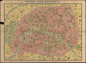
Nouveau Paris monumental : itinéraire pratique de l'etranger dans Paris
304.
The pictorial map, a world of stamps
305.
The pictorial map, stamps of America
306.
The pictorial map, stamps of the U.S.A.
307.
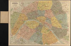
Plan de Paris divisé en 20 arrondissements et 80 quartiers
308.
Aaron Bohrod's America, its history
309.
Atlas of the city of Newton Massachusetts : assessors block system
310.
Boston Elevated Railway system route map
311.
Boston Elevated Railway track lengths of surface lines and subway
312.
Catholic America : a pictorial map portraying the contribution of Catholics in the development of the United States of America...
313.
Paul Sample's America, its soil
314.
Shíjú tú
315.
William Gropper's America, its folklore
316.
Bataan
317.
Camarines Sur : (western part)
318.
Cavite
319.
China, south coast, principal ethnic groups and dialects
320.
Germany, western border regions, agricultural areas (north of the Main and west of the Rhine Rivers)
321.
Germany western border regions rail traffic volume (excluding inter-Ruhr traffic) summer 1939
322.
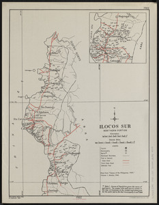
Ilocos Sur : northern portion
323.
Java and Madoera : Indonesian ethnic groups, elementary education, and Christian missions
324.
Java and Madoera principal estate regions showing major products
325.
Lesser Sunda Islands, distribution of population
326.
Lesser Sunda Islands Indonesian Ethnic groups and Christian missions
327.
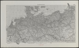
Norddeutschland
328.
Pampanga
329.
Philippine Islands : [outline map]
330.
A pictorial map of North America
331.
Pictorial map of the American continent : featuring the Pan American Highway and showing some of the natural resources, scenic...
332.
Süddeutschland, Österreich, Schweiz und östliches Frankreich
333.
Sumatra wegenkaart
334.
Tayabas (northern part)
335.
Tayabas (southern part)
336.
Uprooted people of the U.S.A.
337.
Ward lines and voting precincts circa 1945
338.
Zambales
339.
The adventures of Mark Twain
340.
Atlas of town of Weymouth Massachusetts
341.
Caroline Islands, Yap Island
342.
China east coast population density
343.
Eight views of the world
344.
Germany, concentration camps (June--1944)
345.
Germany, postal administrative districts, March 1943
346.
Great Britain, her natural & industrial resources
347.
Indians of the U.S.A.
348.
Italy with Vatican City
349.
Mercator map of the world united : a pictorial history of transport and communications and paths to permanent peace
350.
Netherlands New Guinea : approximation of population distribution
351.
Northern Philippines land utilization
352.
Peace map of the world united : a pictorial history of transportation and communications from Jonah to the jet plane as paths...
353.
The story map of flying : being a chronicle of man's conquest of the air
354.
Town of Brookline, Mass. assessors' plans 1944
355.
World map of the major tropical diseases
356.
Algeria and Tunisia, port capacities and major transport routes
357.
Boston Elevated Railway system route map
358.
Global map for global war and global peace
359.
Great circle airways
360.
Invasion and total war victory maps : with decorations, illustrations and military and naval insignia
361.
Iraq water supply and land use
362.
Japan, the target : a pictorial Jap-map
363.
Newsmap : week of October 14 to October 21, 215th week of the war, 97th week of U.S. participation. Monday, October 25, 1943
364.
Newsmap : week of December 16 to December 22, 224th week of the war, 106th week of U.S. Participation. Monday, December 27, 1943
365.
A pictorial map of loveland
366.
Railroads of Lithuania, 1939
367.
Roads and communications of Sinkiang
368.
Town of Brookline Mass. Assessors' plans 1943
369.
Agricultural areas of China
370.
Boston Elevated Railway system route map
371.
The British Commonwealth of Nations
372.
China : waterways and stage routes
373.
French Morocco port traffic, 1938
374.
Germany, main movements of freight traffic
375.
Germany, main movements of freight traffic, 1942
376.
The good neighbor pictorial map of South America
377.
Japanese fishing, areas and seasons
378.
Land utilization in Korea
379.
Morocco, location of mineral resources
380.
Philippine Islands population, 1939 census
381.
Philippine Islands radio stations and cables
382.
Radiotelegraph and radiotelephone communication systems of France : radiotelegraph communication system of the French Ministry...
383.
Saishin ōshū daichizu
384.
South Pacific Ocean, Solomon Islands, Guadalcanal and Florida Is. with a portion of Malaita I. : from British surveys to 1912
385.
South-east New Guinea
386.
The southwest Pacific
387.
Total war battle map
388.
Tribal map of Morocco
389.
The victory war map
390.
The fifth column menaces America on a thousand fronts
391.
Official tourist map of Imperial County, California
392.
Plan of Boston & Maine Railroad terminal division Boston, Cambridge, Somerville, Everett and Medford
393.
Reg Manning's table-top argu-map of the world
394.
The town of Winchester, Massachusetts
395.
38,000,000 escaped -- 10,000,000 died
396.
America the wonderland : a pictorial map of the United States
397.
Art forms of the Pacific area
398.
Boston Elevated Railway system route map
399.
A map of Cape Cod
400.
Massachusetts tourists map : showing tourways, picnic sites, beaches, and camp grounds
« Previous
Next »
1
2
3
4
5
6
7
8
…
109
110
Limit your search
Subject
Real property--Massachusetts--Boston--Maps
2,278
Landowners--Massachusetts--Boston--Maps
2,117
Boston (Mass.)--Maps
1,966
Roxbury (Boston, Mass.)--Maps
351
Dorchester (Boston, Mass.)--Maps
317
Cambridge (Mass.)--Maps
266
Brookline (Mass.)--Maps
236
Real property--Massachusetts--Cambridge--Maps
216
more
Subject
»
Place
North and Central America
7,813
United States
6,574
Suffolk (county)
3,337
Boston
3,197
Massachusetts
3,175
Europe
963
Middlesex (county)
617
Canada
427
more
Place
»
Format
Maps/Atlases
10,940
Manuscripts
215
Prints
51
Books
35
Objects/Artifacts
10
Drawings/Illustrations
8
Posters
4
Available to use
No known restrictions
10,931
Creative Commons license
46
Date
View distribution
Current results range from
1482
to
2023
Date range begin
Date range end
View larger »
Collection
Norman B. Leventhal Map Center Collection
10,999
Boston and New England Maps (Collection of Distinction)
5,105
Urban Maps (Collection of Distinction)
4,845
Maritime Charts and Atlases (Collection of Distinction)
750
American Revolutionary War-Era Maps (Collection of Distinction)
615
Boston Redevelopment Authority Collection
86
Institution
Boston Public Library
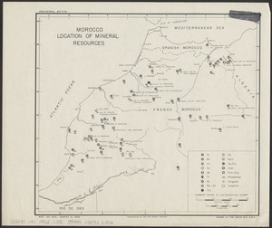
10,999