Skip to search
Skip to main content
Digital Commonwealth
Sign Up / Log In
Search for
Search
Search
Search
Basic
Advanced
Explore
Map
Collections
Institutions
Formats
For Educators
Primary Source Sets
Lesson Plans
Using Primary Sources
Searching Digital Commonwealth
For Institutions
Join Digital Commonwealth
Conferences, Trainings, & Events
How to Contribute Collections
Digitization Services
Board & Committees
Frequently Asked Questions
About
About Digital Commonwealth
News & Announcements
Copyright & Terms of Use
Harmful Content Statement
Partners
API
Contact Us
Boston Public Library
Norman B. Leventhal Map & Education Center Collection
/
Maritime Charts and Atlases (Collection of Distinction)
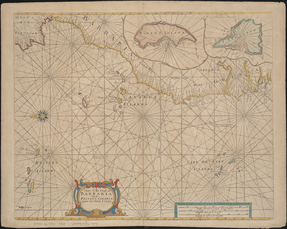
A chart of the coast of Barbaria with the western, Canaria, & Cape de Verd, isles
A chart of the coast of Barbaria with the western, Canaria, & Cape de Verd, isles
×
Item Information
Title:
A chart of the coast of Barbaria with the western, Canaria, & Cape de Verd, isles
Creator:
Thornton, John, 1641-1708
Date:
[1716?]
Format:
Maps/Atlases
Location:
Boston Public Library
Norman B. Leventhal Map & Education Center
Collection (local):
Norman B. Leventhal Map & Education Center Collection
Subjects:
Nautical charts--Early works to 1800
Africa, West--Maps--Early works to 1800
Atlantic Coast (Africa)--Maps--Early works to 1800
Canary Islands--Maps--Early works to 1800
Cape Verde--Maps--Early works to 1800
Places:
West Africa
(area)
Cape Verde
Spain
>
Canary Islands
(island)
Extent:
1 chart : col. ; 42 x 54 cm.
Permalink:
https://ark.digitalcommonwealth.org/ark:/50959/z890s287p
Terms of Use:
No known copyright restrictions.
No known restrictions on use.
Publisher:
London : for R. & W. Mount & T. Page
Scale:
Scale ca. 1:6,000,000.
Language:
English
Notes:
Nautical chart.
Imprint derived from published bibliography.
Oriented with north to the left.
Appears in the author's ed. of the English Pilot, the Third book. London: for R. & W. Mount & T. Page, 1716.
Identifier:
06_01_007109
Call #:
G8737.C6 1716 .T46x
Barcode:
39999059029684
show more...
View MODS XML
More Like This
Paskaart van de cust van Portugal, Barbaria en Genehoa : ...
Partie occidentale de L'Afrique, contenant les pays et etats ...
Archipelagus Atlanticus cum suis insulis Canariis, Hesperidibus et ...
Barbariae et Guineae maritimi à freto Gibraltar ad fluvium ...
Find More Like This >>
Tools
Share
Facebook
Pinterest
X
Reddit
Tumblr
Email
Copy link
Add to Folder
Questions/Comments
Cite This Item
IIIF Manifest
Downloads
Primary (full resolution, uncompressed)
(TIF, 217 MB)
Large (full resolution)
(JPEG, 18.2 MB)
Medium
(JPEG, 347 KB)