Skip to search
Skip to main content
Digital Commonwealth
Sign Up / Log In
Search for
Search
Search
Search
Basic
Advanced
Explore
Map
Collections
Institutions
Formats
For Educators
Primary Source Sets
Lesson Plans
Using Primary Sources
Searching Digital Commonwealth
For Institutions
Join Digital Commonwealth
Conferences, Trainings, & Events
How to Contribute Collections
Digitization Services
Board & Committees
Frequently Asked Questions
About
About Digital Commonwealth
News & Announcements
Copyright & Terms of Use
Harmful Content Statement
Partners
API
Contact Us
American Antiquarian Society
American Revolutionary War-Era Maps (Collection of Distinction)
/
American Antiquarian Society Collection
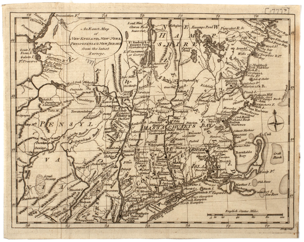
An Exact map of New England, New York, Pensylvania & New Jersey, : from the latest surveys
An Exact map of New England, New York, Pensylvania & New Jersey,
×
Item Information
Title:
An Exact map of New England, New York, Pensylvania & New Jersey, : from the latest surveys
Description:
Subject: Map of New England, Pennsylvania, New York and part of New Jersey.
Engraver:
Lodge, John
Name on Item:
J. Lodge sculp.
Date:
[1778]
Format:
Maps/Atlases
Location:
American Antiquarian Society
Collection (local):
American Antiquarian Society Collection
Subjects:
New England--Maps
New York (State)--Maps
Pennsylvania--Maps
New Jersey--Maps
Places:
New England
(area)
Pennsylvania
New York
New Jersey
Extent:
1 map : engraving ; 20 x 26 cm., on sheet 21 x 27 cm.
Permalink:
https://ark.digitalcommonwealth.org/ark:/50959/z603vg37n
Terms of Use:
Public Domain/No known restrictions on use. Contact host institution to download image.
Contact host institution for more information.
Publisher:
London : [s.n.]
Scale:
Scale [ca. 1:2,400,000]
Language:
English
Referenced by:
http://catalog.mwa.org/vwebv/holdingsInfo?bibId=484585
Notes:
Relief shown pictorially.
From Russell, W. The history of America, London, 1778.
Notes (date):
This date is inferred.
show more...
View MODS XML
More Like This
[Map of parts of Pennsylvania, New York and New Jersey]
Carte de la Nouvelle Angleterre, Nouvelle Yorck, et Pensilvanie. : ...
Map of the canals and rail roads for transporting anthracite coal ...
Map of the State of New York with part of the states of ...
Find More Like This >>
Tools
Share
Facebook
Pinterest
X
Reddit
Tumblr
Email
Copy link
Add to Folder
Questions/Comments
Cite This Item
IIIF Manifest
![[Map of parts of Pennsylvania, New York and New Jersey]](https://bpldcassets.blob.core.windows.net/derivatives/images/commonwealth:6108vt40m/image_thumbnail_300.jpg)


