Skip to search
Skip to main content
Digital Commonwealth
Sign Up / Log In
Search for
Search
Search
Search
Basic
Advanced
Explore
Map
Collections
Institutions
Formats
For Educators
Primary Source Sets
Lesson Plans
Using Primary Sources
Searching Digital Commonwealth
For Institutions
Join Digital Commonwealth
Conferences, Trainings, & Events
How to Contribute Collections
Digitization Services
Board & Committees
Frequently Asked Questions
About
About Digital Commonwealth
News & Announcements
Copyright & Terms of Use
Harmful Content Statement
Partners
API
Contact Us
Boston Public Library
Norman B. Leventhal Map & Education Center Collection
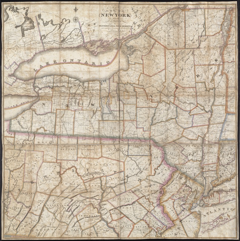
Map of the State of New York with part of the states of Pennsylvania, New Jersey &c
Map of the State of New York with part of the states of Pennsylvania, New Jersey &c
×
Item Information
Title:
Map of the State of New York with part of the states of Pennsylvania, New Jersey &c
Creator:
Lay, Amos, 1765-1851
Name on Item:
compiled corrected & published from the most recent authorities and accurate surveys by Amos Lay, 1817.
Date:
1820
Format:
Maps/Atlases
Location:
Boston Public Library
Norman B. Leventhal Map & Education Center
Collection (local):
Norman B. Leventhal Map & Education Center Collection
Subjects:
New York (State)--Maps
Pennsylvania--Maps
New Jersey--Maps
Middle Atlantic States--Maps
Places:
Pennsylvania
Middle Atlantic
(area)
New York
New Jersey
Extent:
1 map : col. ; 127 x 127 cm.
Permalink:
https://ark.digitalcommonwealth.org/ark:/50959/6t053q169
Terms of Use:
No known copyright restrictions.
No known restrictions on use.
Publisher:
[S.l.] : A. Lay
Edition:
2nd ed., rev.
Scale:
Scale [1:453, 520]
Language:
English
Notes:
Relief shown pictorially.
Hand colored.
Shows township and military tract boundaries.
Cataloging, conservation, and digitization made possible in part by The National Endowment for the Humanities: Exploring the human endeavor.
Identifier:
06_01_004056
Call #:
G3800 1820 .L39
Barcode:
39999059022515
show more...
View MODS XML
More Like This
A survey of the empire group : with a complete distance table, a ...
A survey of the empire group : with a complete distance table, a ...
Map of the country embracing the several routes examined with a ...
Map of the canals and rail roads for transporting anthracite coal ...
Find More Like This >>
Tools
Share
Facebook
Pinterest
X
Reddit
Tumblr
Email
Copy link
Add to Folder
Questions/Comments
Cite This Item
IIIF Manifest
Downloads
Primary (full resolution, uncompressed)
(TIF, 277 MB)
Large (full resolution)
(JPEG, 23.3 MB)
Medium
(JPEG, 322 KB)