Skip to search
Skip to main content
Digital Commonwealth
Folders
Sign Up / Log In
Search for
Search
Search
Search
Basic
Advanced
Explore
Map
Collections
Institutions
Formats
For Educators
Primary Source Sets
Lesson Plans
Using Primary Sources
Searching Digital Commonwealth
For Institutions
Join Digital Commonwealth
Conferences, Trainings, & Events
How to Contribute Collections
Digitization Services
Board & Committees
Frequently Asked Questions
About
About Digital Commonwealth
News & Announcements
Copyright & Terms of Use
Harmful Content Statement
Partners
API
Contact Us
Boston Public Library
Norman B. Leventhal Map & Education Center Collection
/
Maritime Charts and Atlases (Collection of Distinction)
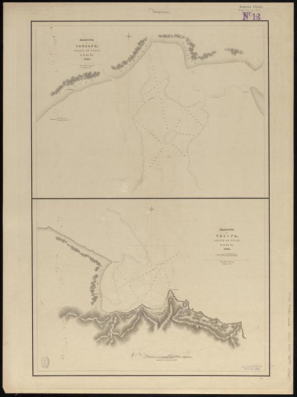
Harbour of Sanaapu, island of Upolu ; Harbour of Falifa, island of Upolu
Harbour of Sanaapu, island of Upolu ; Harbour of Falifa, island of Upolu
×
Item Information
Title:
Harbour of Sanaapu, island of Upolu ; Harbour of Falifa, island of Upolu
Surveyor:
Wilkes, Charles, 1798-1877
Cartographer:
United States Exploring Expedition (1838-1842)
Name on Item:
U.S. Ex. Ex. 1841
Date:
[1840–1849]
Format:
Maps/Atlases
Genre:
Nautical charts
Location:
Boston Public Library
Norman B. Leventhal Map & Education Center
Collection (local):
Norman B. Leventhal Map & Education Center Collection
Subjects:
Safata Harbour (Samoa)--Maps
Falefa Harbor (Samoa)--Maps
Nautical charts--Samoa--Safata Harbour
Nautical charts--Samoa--Falefa Harbor
United States Exploring Expedition (1838-1842)
Places:
Samoa
>
Upolu
(island)
Safata Harbour
Falefa Bay
Extent:
2 maps on 1 sheet ; 59 x 39 cm
Permalink:
https://ark.digitalcommonwealth.org/ark:/50959/n0101d878
Terms of Use:
No known copyright restrictions.
No known restrictions on use.
Scale:
Scale 1:12,000. 1000 ft. to the inch
Scale 1:12,000. 1000 ft. to the inch
Language:
English
Notes:
Relief shown by hachures. Depths shown by soundings and pictorially.
Includes view: Appearance of land back of Falifa.
Published in Narrative of the United States Exploring Expedition : during the years 1838, 1839, 1840, 1841, 1842.
Notes (date):
This date is inferred.
Identifier:
06_01_017643
Call #:
G9567.U6P5 1840 .U552
Barcode:
39999085960902
show more...
View MODS XML
More Like This
Safatu or Sanaapu, island of Upolu ; Harbour of Falifa, island of ...
Ahii and Manhii or Peacock and Wilsons Islands
Apolima, Samoan Group ; Harbour of Oafonu, Isld. of Tutuila, north ...
Bay of Massefao, island of Tutuila ; Bay of Fagaitui, island of ...
Find More Like This >>
Tools
Share
Facebook
Pinterest
X
Reddit
Tumblr
Email
Copy link
Add to Folder
Questions/Comments
Cite This Item
IIIF Manifest
Downloads
Primary (full resolution, uncompressed)
(TIF, 109 MB)
Large (full resolution)
(JPEG, 9.14 MB)
Medium
(JPEG, 61.6 KB)