Skip to search
Skip to main content
Digital Commonwealth
Sign Up / Log In
Search for
Search
Search
Search
Basic
Advanced
Explore
Map
Collections
Institutions
Formats
For Educators
Primary Source Sets
Lesson Plans
Using Primary Sources
Searching Digital Commonwealth
For Institutions
Join Digital Commonwealth
Conferences, Trainings, & Events
How to Contribute Collections
Digitization Services
Board & Committees
Frequently Asked Questions
About
About Digital Commonwealth
News & Announcements
Copyright & Terms of Use
Harmful Content Statement
Partners
API
Contact Us
Boston Public Library
Norman B. Leventhal Map Center Collection
/
Maritime Charts and Atlases (Collection of Distinction)
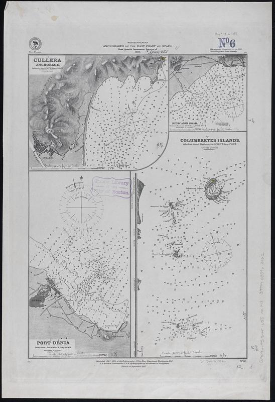
Mediterranean, anchorages on the east coast of Spain : from Spanish government surveys of 1878
Mediterranean, anchorages on the east coast of Spain
×
Item Information
Title:
Mediterranean, anchorages on the east coast of Spain : from Spanish government surveys of 1878
Issuing body:
United States. Hydrographic Office
Date:
1887
Format:
Maps/Atlases
Genre:
Nautical charts
Location:
Boston Public Library
Norman B. Leventhal Map Center
Collection (local):
Norman B. Leventhal Map Center Collection
Subjects:
Cullera (Spain)--Maps
Benicásim (Spain)--Maps
Denia (Spain)--Maps
Columbretes Islands (Spain)--Maps
Navigation--Spain--Cullera
Navigation--Spain--Benicásim
Navigation--Spain--Denia
Navigation--Spain--Columbretes Islands
Places:
Spain
>
Valencian Community
(region)
>
Valencia
(province)
>
Cullera
Spain
>
Valencian Community
(region)
>
Alicante
(province)
>
Denia
Spain
>
Valencian Community
(region)
>
Castellón
(province)
>
Columbretes, Islas
(area)
Spain
>
Valencian Community
(region)
>
Castellón
(province)
>
Benicasim
Extent:
4 maps on 1 sheet ; 43 x 31 cm
Permalink:
https://ark.digitalcommonwealth.org/ark:/50959/ms35ww975
Terms of Use:
No known copyright restrictions.
No known restrictions on use.
Publisher:
Washington, D.C. : Hydrographic Office
Edition:
Edition of September 1887
Scale:
Scale approximately 1:19,700
Scale approximately 1:19,800
Scale approximately 1:26,200
Scale approximately 1:51,800
Language:
English
Table of Contents:
Cullera anchorage
Benicasim Road
Port Dénia
Columbretes Islands.
Notes:
Relief shown by hachures and spot heights. Depths shown by soundings and isolines.
Includes coastal view of the Columbretes Islands.
Identifier:
06_01_017714
Call #:
G9096.P5 svar .U55 no. 143
Barcode:
39999085962262
show more...
View MODS XML
More Like This
The 100th anniversary map of Abraham Lincoln's visit to ...
1630 shoreline
1879. Progress map of the U.S. Geographical Surveys west of the ...
1903 Map of Salem and surrounding places
Find More Like This >>
Tools
Share
Facebook
Pinterest
X
Reddit
Tumblr
Email
Copy link
Add to Folder
Questions/Comments
Cite This Item
IIIF Manifest
Downloads
Primary (full resolution, uncompressed)
(TIF, 87.9 MB)
Large (full resolution)
(JPEG, 7.38 MB)
Medium
(JPEG, 87 KB)