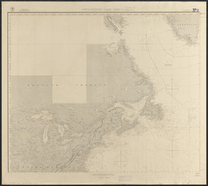
by M.F. Maury A.M. Lieut. U.S. Navy, Superint'dt. of U.S.N. Observatory, Washington ; compiled from materials in the Bureau of Ordnance and Hydrography, Commodore Lewis Warrington, Chief of Bureau ; drawn by Lt. W.B. Whiting, U.S.N.
Sheet 1 only, covering coast of the United States and Central America, of a set of 8 sheets.
Shows winds, currents, magnetic variation, water temperature, tracks of vessels and month of voyage.
![Wind and current chart of the North Atlantic [sheet 1]](https://bpldcassets.blob.core.windows.net/derivatives/images/commonwealth:jh344151t/image_access_800.jpg)