Skip to search
Skip to main content
Digital Commonwealth
Sign Up / Log In
Search for
Search
Search
Search
Basic
Advanced
Explore
Map
Collections
Institutions
Formats
For Educators
Primary Source Sets
Lesson Plans
Using Primary Sources
Searching Digital Commonwealth
For Institutions
Join Digital Commonwealth
Conferences, Trainings, & Events
How to Contribute Collections
Digitization Services
Board & Committees
Frequently Asked Questions
About
About Digital Commonwealth
News & Announcements
Copyright & Terms of Use
Harmful Content Statement
Partners
API
Contact Us
Boston Public Library
Norman B. Leventhal Map Center Collection
/
Urban Maps (Collection of Distinction)
/
Boston and New England Maps (Collection of Distinction)
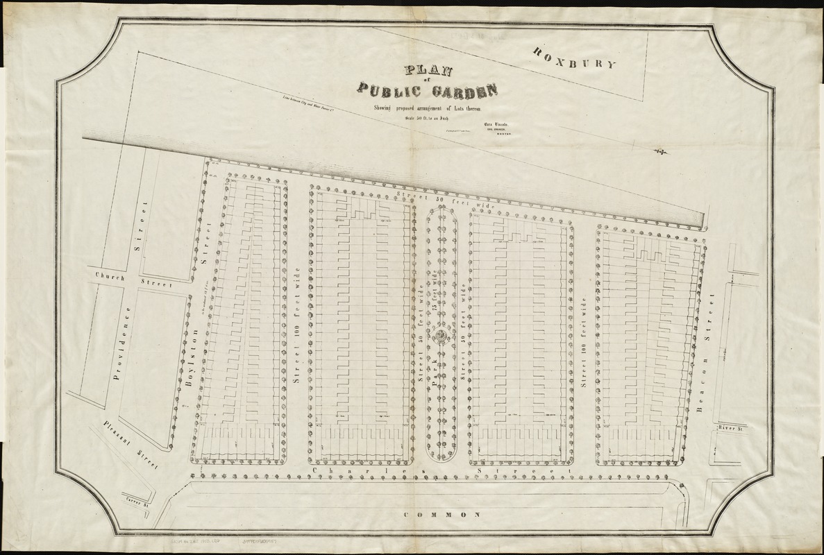
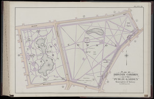
Plan of Public Garden : showing proposed arrangement of lots thereon
Plan of Public Garden
×
Item Information
Title:
Plan of Public Garden : showing proposed arrangement of lots thereon
Creator:
Lincoln, Ezra, 1819-1863
Name on Item:
Ezra Lincoln, civil engineer, Boston.
Date:
[1850]
Format:
Maps/Atlases
Location:
Boston Public Library
Norman B. Leventhal Map Center
Collection (local):
Norman B. Leventhal Map Center Collection
Subjects:
Public Garden (Boston, Mass.)--Maps
Back Bay (Boston, Mass.)--Maps
Places:
Suffolk (county)
>
Boston
>
Public Garden
(park)
Extent:
1 map ; 70 x 97 cm.
Permalink:
https://ark.digitalcommonwealth.org/ark:/50959/9s161j39h
Terms of Use:
No known copyright restrictions.
No known restrictions on use.
Publisher:
Boston : J.H. Bufford & Co. Lith.
Scale:
Scale 1:600.
Language:
English
Notes:
oriented with north toward the bottom right.
Detached from: Report of the Joint Committee on Public Lands in relation to the Public Garden, July, 1850 (City document / Boston (Mass.). City Council ; 1850, no. 18).
Notes (date):
This date is inferred.
Identifier:
06_01_004305
Call #:
G3764.B6:2B2 1850 .L56
Barcode:
39999059005957
39999059006476
show more...
View MODS XML
More Like This
Atlas of the city of Boston, Boston proper : from actual surveys ...
Map of Boston Common and Public Garden
Area plan as of May 1962
Atlas of the city of Boston : city proper : plate P
Find More Like This >>
Tools
Share
Facebook
Pinterest
X
Reddit
Tumblr
Email
Copy link
Add to Folder
Questions/Comments
Cite This Item
IIIF Manifest
Downloads
Primary (full resolution, uncompressed)
(TIF, 217 MB)
Large (full resolution)
(JPEG, 18.2 MB)
Medium
(JPEG, 260 KB)
GeoTIFF (georeferenced)
(TIF, 305 MB)