Skip to search
Skip to main content
Digital Commonwealth
Sign Up / Log In
Search for
Search
Search
Search
Basic
Advanced
Explore
Map
Collections
Institutions
Formats
For Educators
Primary Source Sets
Lesson Plans
Using Primary Sources
Searching Digital Commonwealth
For Institutions
Join Digital Commonwealth
Conferences, Trainings, & Events
How to Contribute Collections
Digitization Services
Board & Committees
Frequently Asked Questions
About
About Digital Commonwealth
News & Announcements
Copyright & Terms of Use
Harmful Content Statement
Partners
API
Contact Us
Boston Public Library
Norman B. Leventhal Map Center Collection
/
Boston Redevelopment Authority Collection
/
Urban Maps (Collection of Distinction)
/
Boston and New England Maps (Collection of Distinction)
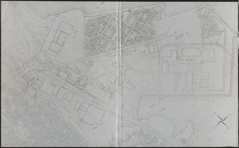
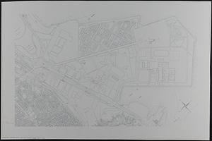
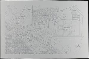
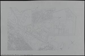
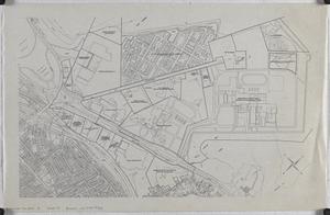
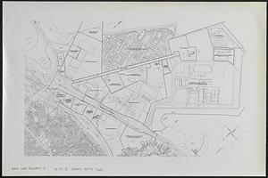
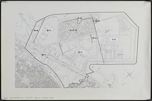
Columbia Point updated base maps
Viewing image 1 of 7
Next >
Columbia Point updated base maps
×
Next
Item Information
Title:
Columbia Point updated base maps
Description:
Outline maps showing streets, property boundaries, building footprints, railroad tracks and other features. Maps manuscript or printed, on translucent mylar or paper, some with manuscript annotations, adhesive labels, or graphic art tape.
Cartographer:
Boston Redevelopment Authority
Date:
[ca. 1990]
Format:
Maps/Atlases
Genre:
Outline maps
Location:
Boston Public Library
Norman B. Leventhal Map Center
Collection (local):
Norman B. Leventhal Map Center Collection
Series:
Boston Redevelopment Authority Maps & Manuscript Plans Collection
Subjects:
Dorchester (Boston, Mass.)--Maps
Real property--Massachusetts--Boston--Maps
Business enterprises--Massachusetts--Boston--Maps
Associations, institutions, etc--Massachusetts--Boston--Maps
City planning--Massachusetts--Boston--Maps
Buildings--Massachusetts--Boston--Maps
Urban renewal--Massachusetts--Boston--Maps
Places:
Suffolk (county)
>
Boston
>
Dorchester
Extent:
7 maps : on paper and plastic ; sheets 105 x 170 cm or smaller
Permalink:
https://ark.digitalcommonwealth.org/ark:/50959/9g5513008
Terms of Use:
No known copyright restrictions.
No known restrictions on use.
Place of origin:
[Boston]
Scale:
Scale 1:1,200. 1" = 100'
Scale 1:2,400. 1" = 200'
Scale approximately 1:4,800
Language:
English
Notes:
Title and scale from post-its on maps.
Oriented with north to the upper left.
Identifier:
06_01_017882A
06_01_017882B
06_01_017882C
06_01_017882D
Call #:
BRA MAP FOLDER 8
Barcode:
30000007747765
show more...
View MODS XML
More Like This
Columbia Point development study
Park Plaza urban renewal area : environmental deficiencies and ...
South Cove : property status and unit ownership
Washington Park urban renewal area Massachusetts r-24 : property ...
Find More Like This >>
Tools
Share
Facebook
Pinterest
X
Reddit
Tumblr
Email
Copy link
Add to Folder
Questions/Comments
Cite This Item
IIIF Manifest
Downloads
Primary (full resolution, uncompressed)
(TIF, multi-file ZIP, 769 MB)
Large (full resolution)
(JPEG, multi-file ZIP, 6.79 MB)
Medium
(JPEG, multi-file ZIP, 470 KB)